TopoQuest Logo
Do you find TopoQuest useful?
Help keep TopoQuest running and adding new maps/features by donating!
Bitcoin:  19c7KJd3qBynnjoSw5npx9KScwjBe4ifkT
Litecoin:  LXs6TkuXGGXo1vDsWCkWVdjQX94eUKd6ui
Home View Maps Find Maps Find Places Resources & Links


Junction City, Kentucky Topographic Map

USGS Map Title: Junction City, KY
USGS Map MRC: 37084E7
DRG (GeoTIFF) Download: o37084e7.tif


Neighboring USGS Topographic Map Quads:


  Perryville, KY  
37084F8
 

  Danville, KY  
37084F7
 

  Bryantsville, KY  
37084F6
 

  Parksville, KY  
37084E8
 

  Junction City, KY  
37084E7
 

  Stanford, KY  
37084E6
 

  Ellisburg, KY  
37084D8
 

  Hustonville, KY  
37084D7
 

  Halls Gap, KY  
37084D6


Map MRC Location:

N38°
W85°
N38°
W84°
H8 H7 H6 H5 H4 H3 H2 H1
G8 G7 G6 G5 G4 G3 G2 G1
F8 F7 F6 F5 F4 F3 F2 F1
E8 E7 E6 E5 E4 E3 E2 E1
D8 D7 D6 D5 D4 D3 D2 D1
C8 C7 C6 C5 C4 C3 C2 C1
B8 B7 B6 B5 B4 B3 B2 B1
A8 A7 A6 A5 A4 A3 A2 A1
N37°
W85°
N37°
W84°

Junction City, KY USGS 1:24K Topographic Map Preview:
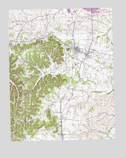
Junction City, KY USGS Topographic Map
Click on map above to begin viewing in our Map Viewer.

This topographic map contains these locations and features:
Feature Name Type Latitude Longitude GNIS ID View Map
Alum SpringsPopulated PlaceN37.5967°W84.8405°507391View Map
Alum Springs Post Office (historical)Post OfficeN37.5961°W84.8410°2565425View Map
Alum Springs Railroad Station (historical)LocaleN37.5961°W84.8458°2565426View Map
Benedict CemeteryCemeteryN37.5342°W84.8234°486847View Map
Berger KnobSummitN37.5559°W84.8577°486903View Map
Bowen ChurchChurchN37.5484°W84.8138°487731View Map
Boyle CountyCivilN37.6244°W84.8668°516857View Map
Boyle County Emergency Medical ServicesBuildingN37.6195°W84.7946°2719113View Map
Boyle County Fire Department Station 4BuildingN37.5837°W84.7721°2636743View Map
Boyle KnobSummitN37.5093°W84.8611°2568333View Map
Caldwell ChurchChurchN37.6129°W84.8533°488591View Map
Caldwell School (historical)SchoolN37.6135°W84.8521°2565432View Map
Catholic KnobSummitN37.5462°W84.8580°489092View Map
City of Junction CityCivilN37.5855°W84.7903°2404815View Map
Danville Fire Department Station 2BuildingN37.6164°W84.7897°2637086View Map
Frog BranchStreamN37.5051°W84.7586°492562View Map
Germantown School (historical)SchoolN37.5493°W84.8598°2565452View Map
Gibson KnobSummitN37.5231°W84.8536°492814View Map
Givans CemeteryCemeteryN37.5731°W84.7611°492869View Map
Givens DepotLocaleN37.5666°W84.7505°2566991View Map
Gray CemeteryCemeteryN37.6042°W84.8361°493195View Map
Harris CreekStreamN37.5470°W84.7724°493804View Map
Harris Creek (historical)Populated PlaceN37.5393°W84.8223°2742217View Map
Isaac Shelby State ShrineLocaleN37.5700°W84.7791°2566727View Map
Junction CityPopulated PlaceN37.5867°W84.7938°495551View Map
Junction City Police DepartmentBuildingN37.5863°W84.7943°2767694View Map
Junction City Volunteer Fire DepartmentBuildingN37.5863°W84.7943°2637125View Map
Knob LickLocaleN37.5892°W84.8067°2565464View Map
Lincoln County Fire Department Station 3BuildingN37.5203°W84.8135°2637132View Map
McDonald ChurchChurchN37.5831°W84.8625°497840View Map
MilledgevillePopulated PlaceN37.5206°W84.8138°508604View Map
Milledgeville Post Office (historical)Post OfficeN37.5202°W84.8143°2566747View Map
Milledgeville Railroad Station (historical)LocaleN37.5198°W84.8143°2566748View Map
MorelandPopulated PlaceN37.5056°W84.8133°498576View Map
Moreland Post Office (historical)Post OfficeN37.5052°W84.8123°2566751View Map
Moreland Railroad Station (historical)LocaleN37.5053°W84.8140°2566752View Map
New Austria Church (historical)ChurchN37.5461°W84.8570°2565471View Map
Persimmon GroveLocaleN37.5898°W84.8438°2565476View Map
Persimmon KnobSummitN37.5912°W84.8408°500442View Map
Peytons Mill (historical)LocaleN37.5050°W84.7581°2566661View Map
Peytons Well (historical)LocaleN37.5046°W84.7578°2566662View Map
Pine KnobSummitN37.5981°W84.8233°500703View Map
Pruitt CemeteryCemeteryN37.5123°W84.8175°501392View Map
Saint Francis of Assisi Catholic Church (historical)ChurchN37.5465°W84.8574°2565480View Map
Saint Joseph Church (historical)ChurchN37.5900°W84.8435°2565481View Map
Saint Joseph School (historical)SchoolN37.5897°W84.8425°2565482View Map
Sand KnobSummitN37.5196°W84.8694°502921View Map
Sand Knob Lookout TowerTowerN37.5195°W84.8696°2568475View Map
Sandidge CemeteryCemeteryN37.5445°W84.8005°502958View Map
Shelby CemeteryCemeteryN37.5662°W84.7838°503316View Map
Shelby CityPopulated PlaceN37.5834°W84.7791°503317View Map
Shelby City Post Office (historical)Post OfficeN37.5808°W84.7818°2565490View Map
Shelby City Railroad Station (historical)LocaleN37.5806°W84.7845°2565491View Map
Stuart Powell FieldAirportN37.5779°W84.7697°517361View Map
Thorn Hill School (historical)SchoolN37.6118°W84.8520°2565496View Map
Travelers Rest Post Office (historical)Post OfficeN37.5699°W84.7786°2566689View Map
WDFB-AM (Junction City)TowerN37.5962°W84.8386°517837View Map
West Lincoln County Emergency Medical ServicesBuildingN37.5204°W84.8135°2719131View Map
White Oak CreekStreamN37.5559°W84.7797°506612View Map

Note: Coordinates in the location and feature list above are referenced to NAD83 datum.


Copyright (C) 2008-2024 Ryan Niemi / Sunset Dynamics ... All Rights Reserved