TopoQuest Logo
Do you find TopoQuest useful?
Help keep TopoQuest running and adding new maps/features by donating!
Bitcoin:  19c7KJd3qBynnjoSw5npx9KScwjBe4ifkT
Litecoin:  LXs6TkuXGGXo1vDsWCkWVdjQX94eUKd6ui
Home View Maps Find Maps Find Places Resources & Links


Halls Gap, Kentucky Topographic Map

USGS Map Title: Halls Gap, KY
USGS Map MRC: 37084D6
DRG (GeoTIFF) Download: o37084d6.tif


Neighboring USGS Topographic Map Quads:


  Junction City, KY  
37084E7
 

  Stanford, KY  
37084E6
 

  Lancaster, KY  
37084E5
 

  Hustonville, KY  
37084D7
 

  Halls Gap, KY  
37084D6
 

  Crab Orchard, KY  
37084D5
 

  Yosemite, KY  
37084C7
 

  Eubank, KY  
37084C6
 

  Woodstock, KY  
37084C5


Map MRC Location:

N38°
W85°
N38°
W84°
H8 H7 H6 H5 H4 H3 H2 H1
G8 G7 G6 G5 G4 G3 G2 G1
F8 F7 F6 F5 F4 F3 F2 F1
E8 E7 E6 E5 E4 E3 E2 E1
D8 D7 D6 D5 D4 D3 D2 D1
C8 C7 C6 C5 C4 C3 C2 C1
B8 B7 B6 B5 B4 B3 B2 B1
A8 A7 A6 A5 A4 A3 A2 A1
N37°
W85°
N37°
W84°

Halls Gap, KY USGS 1:24K Topographic Map Preview:
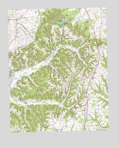
Halls Gap, KY USGS Topographic Map
Click on map above to begin viewing in our Map Viewer.

This topographic map contains these locations and features:
Feature Name Type Latitude Longitude GNIS ID View Map
Arabia Post Office (historical)Post OfficeN37.4090°W84.7371°2566703View Map
Austin ChapelChurchN37.4387°W84.7369°486149View Map
Blaines GapGapN37.4704°W84.7113°487431View Map
Blue LickPopulated PlaceN37.4909°W84.7074°507532View Map
Boneyard HollowValleyN37.4481°W84.7470°2566709View Map
Campbell CemeteryCemeteryN37.4753°W84.7263°488736View Map
Coffey School (historical)SchoolN37.4975°W84.7011°2566717View Map
Ewell Post Office (historical)Post OfficeN37.4554°W84.6354°2566641View Map
Fairview ChurchChurchN37.4634°W84.6322°491919View Map
GenevaPopulated PlaceN37.4395°W84.7463°492769View Map
Grace Fellowship ChurchChurchN37.4811°W84.6404°2559361View Map
Greasy RidgeRidgeN37.4292°W84.6884°2566992View Map
Green River ChurchChurchN37.4623°W84.6849°493289View Map
Gruenheim CemeteryCemeteryN37.4820°W84.7108°493449View Map
Halls GapPopulated PlaceN37.4620°W84.6333°493604View Map
Halls Gap Post Office (historical)Post OfficeN37.4608°W84.6321°2566650View Map
Hanging ForkStreamN37.4901°W84.7398°2566651View Map
HighlandPopulated PlaceN37.4281°W84.6538°494198View Map
Highland ChurchChurchN37.4217°W84.6555°494207View Map
Highland Elementary SchoolSchoolN37.4284°W84.6446°494219View Map
Highland Post Office (historical)Post OfficeN37.4279°W84.6549°2566723View Map
Jacobs Chapel Methodist Church (historical)ChurchN37.4900°W84.7450°2566729View Map
James C Harris ReservoirReservoirN37.4655°W84.6958°2791305View Map
JumboPopulated PlaceN37.4581°W84.6891°495549View Map
Jumbo Post Office (historical)Post OfficeN37.4575°W84.6915°2566730View Map
Kings Mountain School (historical)SchoolN37.3753°W84.6860°2566735View Map
Lincoln CountyCivilN37.4554°W84.6608°516915View Map
Lincoln County Fire Department Station 7BuildingN37.4319°W84.6463°2636499View Map
Martins BranchStreamN37.4865°W84.7399°497626View Map
Mason Gap School (historical)SchoolN37.4813°W84.6785°2566742View Map
Masons GapGapN37.4808°W84.6794°497666View Map
McGills CreekStreamN37.4467°W84.7019°497860View Map
McKinney CreekStreamN37.4304°W84.7424°497915View Map
Memorial High SchoolSchoolN37.3965°W84.6538°498060View Map
MiraclePopulated PlaceN37.4667°W84.6824°508618View Map
Miracle School (historical)SchoolN37.4638°W84.6850°2566749View Map
Mount Moriah CemeteryCemeteryN37.4330°W84.6427°2566753View Map
Mount Moriah ChurchChurchN37.4337°W84.6419°498779View Map
Mount Moriah School (historical)SchoolN37.4338°W84.6423°2566754View Map
Naylor RidgeRidgeN37.4620°W84.7288°499190View Map
New Bethel Church of ChristChurchN37.4481°W84.7052°499286View Map
Peck HollowValleyN37.4407°W84.7264°500340View Map
Pleasant Point (historical)Populated PlaceN37.3904°W84.6620°2566665View Map
Pleasant Point CemeteryCemeteryN37.3887°W84.6662°2566666View Map
Pleasnt Point Baptist ChurchChurchN37.3890°W84.6674°500886View Map
Saufley Post Office (historical)Post OfficeN37.4805°W84.6315°2566678View Map
Saufley School (historical)SchoolN37.4821°W84.6321°2566679View Map
Sims CreekStreamN37.4045°W84.7302°503548View Map
South ForkPopulated PlaceN37.4095°W84.7380°503903View Map
South Fork ChurchChurchN37.3965°W84.7416°503913View Map
South Fork Church CemeteryCemeteryN37.3958°W84.7413°2566680View Map
South Fork Railroad Station (historical)LocaleN37.4089°W84.7383°2566681View Map
South Fork School (historical)SchoolN37.4074°W84.7420°2566682View Map
Stanford ReservoirReservoirN37.4865°W84.6800°504255View Map
Sugar Loaf GraveyardCemeteryN37.4849°W84.6512°2566687View Map
SugarloafSummitN37.4865°W84.6483°504700View Map
Tunnel City (historical)Populated PlaceN37.3795°W84.7011°2742227View Map
Tunnel CreekStreamN37.4017°W84.7297°505569View Map
TurnersvillePopulated PlaceN37.4904°W84.7388°505671View Map
Turnersville Post Office (historical)Post OfficeN37.4895°W84.7388°2566691View Map
Waters CemeteryCemeteryN37.3831°W84.7033°506268View Map
Waynesburg DivisionCivilN37.3756°W84.6682°1937310View Map
Yocum (historical)Populated PlaceN37.4400°W84.7278°2742231View Map
Yocum Church of God (historical)ChurchN37.4305°W84.7359°2566698View Map
Yocum School (historical)SchoolN37.4304°W84.7366°2566699View Map
Youngs Mill Post Office (historical)Post OfficeN37.4621°W84.6351°2566700View Map

Note: Coordinates in the location and feature list above are referenced to NAD83 datum.


Copyright (C) 2008-2024 Ryan Niemi / Sunset Dynamics ... All Rights Reserved