TopoQuest Logo
Do you find TopoQuest useful?
Help keep TopoQuest running and adding new maps/features by donating!
Bitcoin:  19c7KJd3qBynnjoSw5npx9KScwjBe4ifkT
Litecoin:  LXs6TkuXGGXo1vDsWCkWVdjQX94eUKd6ui
Home View Maps Find Maps Find Places Resources & Links


Bancroft, Louisiana Topographic Map

USGS Map Title: Bancroft, LA
USGS Map MRC: 30093E6
DRG (GeoTIFF) Download: o30093e6.tif


Neighboring USGS Topographic Map Quads:


  Bleakwood, TX  
30093F7
 

  Bon Wier, TX  
30093F6
 

  Merryville South, LA  
30093F5
 

  Trout Creek, TX  
30093E7
 

  Bancroft, LA  
30093E6
 

  Fields, LA  
30093E5
 

  Sudduth Bluff, TX  
30093D7
 

  Shoats Creek, LA  
30093D6
 

  Clark Hollow, LA  
30093D5


Map MRC Location:

N31°
W94°
N31°
W93°
H8 H7 H6 H5 H4 H3 H2 H1
G8 G7 G6 G5 G4 G3 G2 G1
F8 F7 F6 F5 F4 F3 F2 F1
E8 E7 E6 E5 E4 E3 E2 E1
D8 D7 D6 D5 D4 D3 D2 D1
C8 C7 C6 C5 C4 C3 C2 C1
B8 B7 B6 B5 B4 B3 B2 B1
A8 A7 A6 A5 A4 A3 A2 A1
N30°
W94°
N30°
W93°

Bancroft, LA USGS 1:24K Topographic Map Preview:
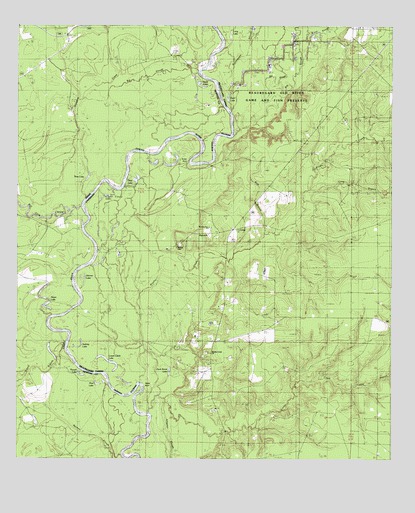
Bancroft, LA USGS Topographic Map
Click on map above to begin viewing in our Map Viewer.

This topographic map contains these locations and features:
Feature Name Type Latitude Longitude GNIS ID View Map
BancroftPopulated PlaceN30.5652°W93.6855°532300View Map
Bancroft Oil FieldOilfieldN30.5371°W93.6907°553343View Map
Bancroft School (historical)SchoolN30.5669°W93.6810°544751View Map
Bee SloughGutN30.6102°W93.6668°541995View Map
Big Cow CreekStreamN30.5735°W93.7285°1352046View Map
Big SloughGutN30.6108°W93.7060°1352132View Map
Big SloughStreamN30.5941°W93.6768°533110View Map
Biloxi SchoolSchoolN30.6208°W93.7338°1352203View Map
Bird BranchStreamN30.5652°W93.6677°541996View Map
Bose LakeLakeN30.5813°W93.7266°1352708View Map
Brushy CreekStreamN30.5141°W93.7060°533478View Map
Brushy Creek Missionary Baptist ChurchChurchN30.5305°W93.6860°553807View Map
Brushy Creek School (historical)SchoolN30.5374°W93.6668°544748View Map
Bugger BranchStreamN30.6133°W93.6563°533519View Map
Caney BranchStreamN30.5213°W93.6363°533736View Map
Caney CreekStreamN30.5149°W93.7054°533739View Map
Cool SloughStreamN30.6224°W93.6566°534099View Map
Donahoe CreekStreamN30.5760°W93.7271°1356150View Map
Drain LakeLakeN30.5810°W93.7105°554263View Map
Duck LakeLakeN30.6042°W93.6800°554283View Map
Duck Roost LakeSwampN30.5283°W93.7091°534637View Map
Fredonia ChurchChurchN30.6249°W93.7285°1357702View Map
Friendship ChurchChurchN30.5663°W93.6771°542002View Map
Howell LakeLakeN30.5244°W93.7283°1359745View Map
Long BranchStreamN30.5780°W93.6530°542006View Map
Long LakeLakeN30.6208°W93.6793°555139View Map
Lower Circle LakeLakeN30.5282°W93.7195°555183View Map
Morning Star Church of God in ChristChurchN30.5669°W93.6863°556662View Map
North Bancroft Oil FieldOilfieldN30.6144°W93.6666°537709View Map
Pecan LakeLakeN30.5466°W93.7406°1364979View Map
Pine LakeLakeN30.5219°W93.7223°1365294View Map
Rattlesnake SloughStreamN30.5946°W93.6768°538504View Map
Salem Ferry (historical)CrossingN30.5660°W93.7280°544750View Map
Sime LakeLakeN30.6079°W93.6894°1368289View Map
Simms BranchStreamN30.5330°W93.7343°1368299View Map
Skinner LakeLakeN30.5525°W93.7276°556058View Map
Skinner Lakes Oil FieldOilfieldN30.5560°W93.7155°544749View Map
Snider BendBendN30.5858°W93.6910°1368564View Map
Spikes CemeteryCemeteryN30.5619°W93.6957°539552View Map
Sydney LakeLakeN30.5332°W93.7287°556194View Map
Taylor BendBendN30.5216°W93.7080°544747View Map
Upper Circle LakeLakeN30.5763°W93.7188°556308View Map
Whitmans Ferry (historical)CrossingN30.5935°W93.6791°1630131View Map

Note: Coordinates in the location and feature list above are referenced to NAD83 datum.


Copyright (C) 2008-2024 Ryan Niemi / Sunset Dynamics ... All Rights Reserved