TopoQuest Logo
Do you find TopoQuest useful?
Help keep TopoQuest running and adding new maps/features by donating!
Bitcoin:  19c7KJd3qBynnjoSw5npx9KScwjBe4ifkT
Litecoin:  LXs6TkuXGGXo1vDsWCkWVdjQX94eUKd6ui
Home View Maps Find Maps Find Places Resources & Links


Sudduth Bluff, Texas Topographic Map

USGS Map Title: Sudduth Bluff, TX
USGS Map MRC: 30093D7
DRG (GeoTIFF) Download: o30093d7.tif


Neighboring USGS Topographic Map Quads:


  Call Junction, TX  
30093E8
 

  Trout Creek, TX  
30093E7
 

  Bancroft, LA  
30093E6
 

  Buna, TX  
30093D8
 

  Sudduth Bluff, TX  
30093D7
 

  Shoats Creek, LA  
30093D6
 

  Gist, TX  
30093C8
 

  Hartburg, TX  
30093C7
 

  Starks, LA  
30093C6


Map MRC Location:

N31°
W94°
N31°
W93°
H8 H7 H6 H5 H4 H3 H2 H1
G8 G7 G6 G5 G4 G3 G2 G1
F8 F7 F6 F5 F4 F3 F2 F1
E8 E7 E6 E5 E4 E3 E2 E1
D8 D7 D6 D5 D4 D3 D2 D1
C8 C7 C6 C5 C4 C3 C2 C1
B8 B7 B6 B5 B4 B3 B2 B1
A8 A7 A6 A5 A4 A3 A2 A1
N30°
W94°
N30°
W93°

Sudduth Bluff, TX USGS 1:24K Topographic Map Preview:
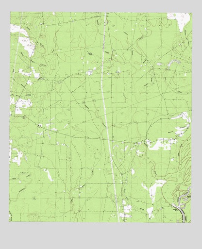
Sudduth Bluff, TX USGS Topographic Map
Click on map above to begin viewing in our Map Viewer.

This topographic map contains these locations and features:
Feature Name Type Latitude Longitude GNIS ID View Map
Alabama BranchStreamN30.4360°W93.7891°1350924View Map
Big BranchStreamN30.4471°W93.8580°1352033View Map
Bivens BranchStreamN30.4696°W93.7916°1352268View Map
Black Marsh SloughGutN30.3877°W93.7932°1372608View Map
Bumpy BaygallSwampN30.4427°W93.8668°1353300View Map
Buna Lookout TowerTowerN30.4374°W93.8646°1384534View Map
Cole SloughGutN30.4671°W93.7660°1354766View Map
Devil's Pocket Volunteer Fire DepartmentBuildingN30.4236°W93.8042°2655551View Map
Double BranchStreamN30.4771°W93.8510°1356169View Map
Griners MarshSwampN30.4563°W93.7795°1358455View Map
Laurel Sudduth Bluff CemeteryCemeteryN30.3824°W93.7721°1371971View Map
Mayhaw MarshSwampN30.4751°W93.8194°1362335View Map
Nichols CreekStreamN30.3858°W93.7618°1363875View Map
Nichols Creek ChurchChurchN30.4205°W93.7863°1363876View Map
Nixs Ferry (historical)CrossingN30.3835°W93.7582°551322View Map
Pine Log BranchStreamN30.4505°W93.8585°1365296View Map
Pocket SloughStreamN30.4541°W93.7902°1365493View Map
Shepherds BranchStreamN30.3874°W93.8735°1376090View Map
Spring BranchStreamN30.4666°W93.8538°1368925View Map
Sudduth BluffCliffN30.3831°W93.7588°2743308View Map
Wright CemeteryCemeteryN30.4449°W93.8674°1384046View Map

Note: Coordinates in the location and feature list above are referenced to NAD83 datum.


Copyright (C) 2008-2025 Ryan Niemi / Sunset Dynamics ... All Rights Reserved