TopoQuest Logo
Do you find TopoQuest useful?
Help keep TopoQuest running and adding new maps/features by donating!
Bitcoin:  19c7KJd3qBynnjoSw5npx9KScwjBe4ifkT
Litecoin:  LXs6TkuXGGXo1vDsWCkWVdjQX94eUKd6ui
Home View Maps Find Maps Find Places Resources & Links


Kawkawlin, Michigan Topographic Map

USGS Map Title: Kawkawlin, MI
USGS Map MRC: 43083F8
DRG (GeoTIFF) Download: o43083f8.tif


Neighboring USGS Topographic Map Quads:


  Crump, MI  
43084G1
 

  Pinconning, MI  
43083G8


  Willard, MI  
43084F1
 

  Kawkawlin, MI  
43083F8
 

  Bay City NE, MI  
43083F7
 

  Auburn, MI  
43084E1
 

  Bay City, MI  
43083E8
 

  Essexville, MI  
43083E7


Map MRC Location:

N44°
W84°
N44°
W83°
H8 H7 H6 H5 H4 H3 H2 H1
G8 G7 G6 G5 G4 G3 G2 G1
F8 F7 F6 F5 F4 F3 F2 F1
E8 E7 E6 E5 E4 E3 E2 E1
D8 D7 D6 D5 D4 D3 D2 D1
C8 C7 C6 C5 C4 C3 C2 C1
B8 B7 B6 B5 B4 B3 B2 B1
A8 A7 A6 A5 A4 A3 A2 A1
N43°
W84°
N43°
W83°

Kawkawlin, MI USGS 1:24K Topographic Map Preview:
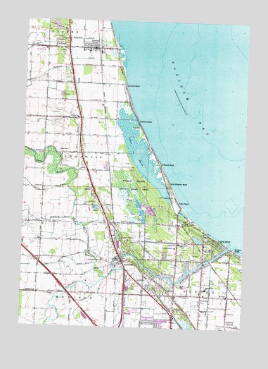
Kawkawlin, MI USGS Topographic Map
Click on map above to begin viewing in our Map Viewer.

This topographic map contains these locations and features:
Feature Name Type Latitude Longitude GNIS ID View Map
Alpine Village Mobile Home ParkPopulated PlaceN43.6319°W83.9347°2547328View Map
Apostolic Christian ChurchChurchN43.6258°W83.9144°2518749View Map
Bangor Central SchoolSchoolN43.6411°W83.8955°620548View Map
Bangor North Central SchoolSchoolN43.6575°W83.8933°620551View Map
Bangor South Central SchoolSchoolN43.6314°W83.8947°620552View Map
Bangor Township Fire Department Station 7BuildingN43.6386°W83.8966°2626940View Map
Bangor-Lincoln SchoolSchoolN43.6595°W83.9114°620553View Map
Bay City State ParkParkN43.6661°W83.9053°620778View Map
Bay City WaterworksLocaleN43.6631°W83.8961°1623226View Map
Bay CountyCivilN43.7214°W83.9418°1622951View Map
Bay Regional Medical Center Emergency Medical Services Station 5BuildingN43.6250°W83.9025°2662016View Map
Berea Christian ChurchChurchN43.6381°W83.8833°2547835View Map
Brentwood Estates Mobile Home ParkPopulated PlaceN43.6417°W83.9228°2546938View Map
Brissette BeachPopulated PlaceN43.7092°W83.9361°622004View Map
Brissette SchoolSchoolN43.7106°W83.9705°622005View Map
Calvary CemeteryCemeteryN43.6558°W83.9422°622477View Map
Charter Township of BangorCivilN43.6524°W83.8951°1625878View Map
Church of GodChurchN43.6600°W83.9344°1618638View Map
Church of GodChurchN43.7403°W83.9150°1618639View Map
Cornerstone Baptist ChurchChurchN43.6311°W83.9133°2518748View Map
Davenport UniversitySchoolN43.6256°W83.9403°2547327View Map
Donahue BeachPopulated PlaceN43.6567°W83.8797°624779View Map
Garvey DrainCanalN43.6800°W83.9880°626680View Map
Heavenly Rest CemeteryCemeteryN43.6614°W83.9436°628041View Map
Hembling DrainCanalN43.6692°W83.9722°628074View Map
Hoyle's Marina and CampgroundLocaleN43.7306°W83.9464°2547403View Map
Hoyles MarinaLocaleN43.7420°W83.9436°1618525View Map
Huron Woods Nursing CenterHospitalN43.7033°W83.9681°2547410View Map
Indian Town DrainCanalN43.6478°W83.9080°629019View Map
KawkawlinPopulated PlaceN43.6520°W83.9430°629480View Map
Kawkawlin Community ChurchChurchN43.6528°W83.9400°2547408View Map
Kawkawlin Oil FieldOilfieldN43.6392°W83.9539°1623458View Map
Kawkawlin Post OfficePost OfficeN43.6514°W83.9453°2547407View Map
Kawkawlin RiverStreamN43.6584°W83.8833°629483View Map
Kawkawlin River ChurchChurchN43.6325°W83.9133°629484View Map
Kawkawlin Station (historical)LocaleN43.6522°W83.9428°2547406View Map
Kawkawlin Township Fire Department Station 14BuildingN43.7095°W83.9750°2547409View Map
Kawkawlin Village SchoolSchoolN43.6522°W83.9547°629485View Map
Kerr DrainCanalN43.7006°W83.9700°1618526View Map
Killarney BeachPopulated PlaceN43.6922°W83.9225°629661View Map
Lagoon BeachPopulated PlaceN43.6611°W83.8900°629949View Map
LinwoodPopulated PlaceN43.7392°W83.9622°630524View Map
Linwood BeachPopulated PlaceN43.7239°W83.9436°630525View Map
Linwood Elementary SchoolSchoolN43.7406°W83.9683°2547398View Map
Linwood Post OfficePost OfficeN43.7388°W83.9619°2547399View Map
Linwood StationLocaleN43.7383°W83.9592°2547400View Map
Little Killarney BeachPopulated PlaceN43.6842°W83.9178°630653View Map
Maple Leaf Golf CourseLocaleN43.7433°W83.9819°2547404View Map
Marsh Point Par Three Golf CourseLocaleN43.6678°W83.9131°2546944View Map
Millpond DrainStreamN43.6484°W83.9464°632418View Map
Mount Vernon SchoolSchoolN43.6384°W83.8839°632845View Map
North Branch Kawkawlin RiverStreamN43.6453°W83.9530°633516View Map
North Euclid Church of GodChurchN43.6428°W83.9133°2518747View Map
Oa-At-Ka Beach Station (historical)LocaleN43.6556°W83.8814°2547453View Map
Oakbrook Mobile Home ParkPopulated PlaceN43.6589°W83.8956°2546932View Map
Ogaukawning Church Historical MarkerParkN43.6464°W83.9128°2548242View Map
Popp DrainCanalN43.6495°W83.9919°635246View Map
Protestant CemeteryCemeteryN43.7394°W83.9781°2548200View Map
Railroad DrainStreamN43.7345°W83.9466°635595View Map
Rosebush DrainCanalN43.7384°W83.9497°636221View Map
Saginaw Bay Historical MarkerParkN43.6669°W83.9017°2548241View Map
Saint Ann CemeteryCemeteryN43.7392°W83.9819°636532View Map
Saint Anne Parish SchoolSchoolN43.7383°W83.9644°2547402View Map
Saint Annes ChurchChurchN43.7383°W83.9644°2547401View Map
Saint Maria Goretti ChurchChurchN43.6578°W83.9133°636851View Map
Shady Rest Mobile PlazaPopulated PlaceN43.6425°W83.9083°2546937View Map
Spring Valley Golf CourseLocaleN43.6683°W83.9431°2547417View Map
Tobico BeachPopulated PlaceN43.6764°W83.9122°1614898View Map
Tobico LagoonLakeN43.6716°W83.9094°1614899View Map
Tobico MarshLakeN43.6911°W83.9312°1614900View Map
Tobico Marsh State Game AreaParkN43.6834°W83.9391°1614901View Map
Townhall SchoolSchoolN43.6967°W83.9891°1615002View Map
Township of KawkawlinCivilN43.6998°W83.9753°1626552View Map
Valley Mobile Home ParkPopulated PlaceN43.6431°W83.9375°2546934View Map
Willow Tree Village Mobile Home ParkPopulated PlaceN43.6347°W83.9006°2546935View Map

Note: Coordinates in the location and feature list above are referenced to NAD83 datum.


Copyright (C) 2008-2025 Ryan Niemi / Sunset Dynamics ... All Rights Reserved