TopoQuest Logo
Do you find TopoQuest useful?
Help keep TopoQuest running and adding new maps/features by donating!
Bitcoin:  19c7KJd3qBynnjoSw5npx9KScwjBe4ifkT
Litecoin:  LXs6TkuXGGXo1vDsWCkWVdjQX94eUKd6ui
Home View Maps Find Maps Find Places Resources & Links


Kellogg West, Idaho Topographic Map

USGS Map Title: Kellogg West, ID
USGS Map MRC: 47116E2
DRG (GeoTIFF) Download: o47116e2.tif


Neighboring USGS Topographic Map Quads:


  Bumblebee Peak, ID  
47116F3
 

  Steamboat Creek, ID  
47116F2
 

  Grizzly Mountain, ID  
47116F1
 

  Cataldo, ID  
47116E3
 

  Kellogg West, ID  
47116E2
 

  Kellogg East, ID  
47116E1
 

  Twin Crags, ID  
47116D3
 

  Masonia, ID  
47116D2
 

  Polaris Peak, ID  
47116D1


Map MRC Location:

N48°
W117°
N48°
W116°
H8 H7 H6 H5 H4 H3 H2 H1
G8 G7 G6 G5 G4 G3 G2 G1
F8 F7 F6 F5 F4 F3 F2 F1
E8 E7 E6 E5 E4 E3 E2 E1
D8 D7 D6 D5 D4 D3 D2 D1
C8 C7 C6 C5 C4 C3 C2 C1
B8 B7 B6 B5 B4 B3 B2 B1
A8 A7 A6 A5 A4 A3 A2 A1
N47°
W117°
N47°
W116°

Kellogg West, ID USGS 1:24K Topographic Map Preview:
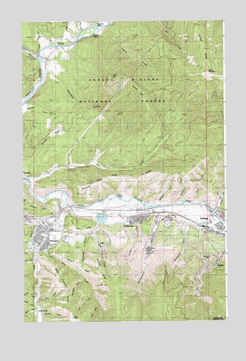
Kellogg West, ID USGS Topographic Map
Click on map above to begin viewing in our Map Viewer.

This topographic map contains these locations and features:
Feature Name Type Latitude Longitude GNIS ID View Map
Amy GulchValleyN47.5105°W116.2404°376602View Map
Amy-Matchless MineMineN47.5088°W116.2416°376603View Map
Antimony MineMineN47.5360°W116.2460°376670View Map
Bear CreekStreamN47.5596°W116.2488°377122View Map
Blue Star RidgeRidgeN47.5380°W116.2141°377952View Map
Bobby Anderson MineMineN47.5169°W116.2393°377976View Map
Bobby Anderson RidgeRidgeN47.5146°W116.2266°377977View Map
BradleyPopulated PlaceN47.5463°W116.1607°394295View Map
Bradley SidingLocaleN47.5455°W116.1632°378182View Map
Bunker Hill MineMineN47.5116°W116.1452°378504View Map
Bunker Hill Tailings Number One DamDamN47.5383°W116.1560°398901View Map
Bunker Hill Tailings Number Three DamDamN47.5516°W116.1460°398903View Map
Bunker Hill Tailings Number Two DamDamN47.5366°W116.1477°398902View Map
Caldwell GulchValleyN47.5505°W116.1663°378705View Map
City of KelloggCivilN47.5371°W116.1420°2410173View Map
City of PinehurstCivilN47.5364°W116.2329°2411424View Map
City of SmeltervilleCivilN47.5426°W116.1773°2411909View Map
City of WardnerCivilN47.5190°W116.1357°2412180View Map
Cook CreekStreamN47.5496°W116.1446°399836View Map
Corrigan RidgeRidgeN47.5219°W116.2035°379809View Map
Deadmans EddyBayN47.6235°W116.1977°380339View Map
Deadwood GulchValleyN47.5396°W116.1512°380349View Map
Deer Lick GulchValleyN47.5102°W116.2085°380468View Map
Devils ElbowBendN47.6205°W116.2074°380533View Map
Fubar PeakSummitN47.5499°W116.2493°382122View Map
General MineMineN47.5258°W116.2279°382233View Map
Government GulchValleyN47.5377°W116.1699°382474View Map
Grader GulchValleyN47.5069°W116.2446°382480View Map
Graham MountainSummitN47.6033°W116.1357°382491View Map
Graham RidgeRidgeN47.6019°W116.1282°382495View Map
Grouse CreekStreamN47.5413°W116.1968°382725View Map
Hauck GulchValleyN47.5044°W116.2449°382965View Map
Haystack PeakSummitN47.5266°W116.1354°396634View Map
Hazendorf GulchValleyN47.6013°W116.2285°396637View Map
Heim GulchValleyN47.5269°W116.2454°383048View Map
Hultman GulchValleyN47.5894°W116.2466°383528View Map
Humboldt GulchValleyN47.5391°W116.2041°383534View Map
Idaho GulchValleyN47.5066°W116.2046°383603View Map
Jackass CreekStreamN47.5446°W116.1329°383819View Map
Kellogg Golf ClubLocaleN47.5352°W116.2307°400280View Map
Kellogg High SchoolSchoolN47.5513°W116.1283°384126View Map
Kellogg Middle SchoolSchoolN47.5437°W116.1337°401509View Map
Kellogg Police StationBuildingN47.5381°W116.1378°2722382View Map
Kingston RidgeRidgeN47.5483°W116.2446°384243View Map
Klondike GulchValleyN47.5030°W116.2393°384276View Map
Last Chance MineMineN47.5188°W116.1396°384460View Map
Lightner DrawValleyN47.6191°W116.2377°384626View Map
LinforPopulated PlaceN47.6083°W116.2357°396797View Map
Linfor HillSummitN47.6013°W116.1954°384700View Map
Little North Fork Coeur d'Alene RiverStreamN47.6102°W116.2402°393805View Map
Little Pine CreekStreamN47.5471°W116.2266°384912View Map
Marsh CreekStreamN47.6177°W116.2160°386483View Map
Matchless GulchValleyN47.5108°W116.2443°386537View Map
Maude RidgeRidgeN47.5241°W116.2160°373859View Map
McKinley GulchValleyN47.5171°W116.2146°386641View Map
McLeod HillSummitN47.5571°W116.2102°396865View Map
McPhee GulchValleyN47.5680°W116.2460°399988View Map
Milo CreekStreamN47.5296°W116.1268°386981View Map
PagePopulated PlaceN47.5327°W116.2038°397004View Map
Page MineMineN47.5283°W116.2007°388120View Map
Pine CreekStreamN47.5519°W116.2232°388500View Map
Pine CreekPopulated PlaceN47.5485°W116.2224°397033View Map
Pine PointSummitN47.5014°W116.2200°2559368View Map
Pine Point LookoutLocaleN47.5016°W116.2202°394294View Map
PinehurstPopulated PlaceN47.5388°W116.2374°397038View Map
Pinehurst Elementary SchoolSchoolN47.5377°W116.2375°401048View Map
Pinehurst Post OfficePost OfficeN47.5376°W116.2349°2766875View Map
Shoshone County AirportAirportN47.5472°W116.1867°400848View Map
Shoshone County Fire Protection District 2 Pinehurst StationBuildingN47.5381°W116.2340°2619045View Map
Shoshone Medical CenterHospitalN47.5465°W116.1309°399547View Map
Silver CreekStreamN47.5269°W116.2010°390422View Map
Silver Valley Christian AcademySchoolN47.5437°W116.1283°399386View Map
Slaughterhouse GulchValleyN47.5260°W116.1285°390585View Map
Smelter HeightsPopulated PlaceN47.5391°W116.1596°398143View Map
SmeltervillePopulated PlaceN47.5427°W116.1816°398144View Map
Smelterville Post OfficePost OfficeN47.5433°W116.1780°2781800View Map
South Fork RidgeRidgeN47.5605°W116.1871°391006View Map
Studer CreekStreamN47.6152°W116.2329°391560View Map
Sunnyside Elementary SchoolSchoolN47.5424°W116.1316°401158View Map
SweeneyPopulated PlaceN47.5402°W116.1696°397230View Map
Sweeney GulchValleyN47.5505°W116.1546°391764View Map
Thomas CreekStreamN47.6227°W116.1988°392020View Map
Thomas HillSummitN47.5963°W116.1774°397249View Map
Tucker GulchValleyN47.5355°W116.2263°392440View Map
WardnerPopulated PlaceN47.5227°W116.1341°400161View Map
Weir GulchValleyN47.5316°W116.2468°392985View Map
West Shoshone ParkParkN47.5421°W116.2282°398989View Map

Note: Coordinates in the location and feature list above are referenced to NAD83 datum.


Copyright (C) 2008-2025 Ryan Niemi / Sunset Dynamics ... All Rights Reserved