TopoQuest Logo
Do you find TopoQuest useful?
Help keep TopoQuest running and adding new maps/features by donating!
Bitcoin:  19c7KJd3qBynnjoSw5npx9KScwjBe4ifkT
Litecoin:  LXs6TkuXGGXo1vDsWCkWVdjQX94eUKd6ui
Home View Maps Find Maps Find Places Resources & Links


Kelly, North Carolina Topographic Map

USGS Map Title: Kelly, NC
USGS Map MRC: 34078D3
DRG (GeoTIFF) Download: o34078d3.tif


Neighboring USGS Topographic Map Quads:


  Singletary Lake, NC  
34078E4
 

  Rowan, NC  
34078E3
 

  Atkinson, NC  
34078E2
 

  Council, NC  
34078D4
 

  Kelly, NC  
34078D3
 

  Point Caswell, NC  
34078D2
 

  Lake Waccamaw East, NC  
34078C4
 

  Freeman, NC  
34078C3
 

  Acme, NC  
34078C2


Map MRC Location:

N35°
W79°
N35°
W78°
H8 H7 H6 H5 H4 H3 H2 H1
G8 G7 G6 G5 G4 G3 G2 G1
F8 F7 F6 F5 F4 F3 F2 F1
E8 E7 E6 E5 E4 E3 E2 E1
D8 D7 D6 D5 D4 D3 D2 D1
C8 C7 C6 C5 C4 C3 C2 C1
B8 B7 B6 B5 B4 B3 B2 B1
A8 A7 A6 A5 A4 A3 A2 A1
N34°
W79°
N34°
W78°

Kelly, NC USGS 1:24K Topographic Map Preview:
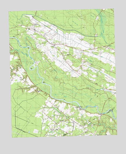
Kelly, NC USGS Topographic Map
Click on map above to begin viewing in our Map Viewer.

This topographic map contains these locations and features:
Feature Name Type Latitude Longitude GNIS ID View Map
Beaverdam CreekStreamN34.3835°W78.2636°1025128View Map
Big SloughSwampN34.4148°W78.3089°981454View Map
Bladen Technical CollegeSchoolN34.4554°W78.3072°1026268View Map
Bob Peterson BaySwampN34.4516°W78.2806°981666View Map
Burnt BaySwampN34.4932°W78.2753°982293View Map
Carvers CreekStreamN34.4610°W78.3736°1025222View Map
Centerville ChurchChurchN34.4643°W78.3225°1000970View Map
CollyPopulated PlaceN34.4602°W78.2544°1019742View Map
East ArcadiaPopulated PlaceN34.3821°W78.3233°1020075View Map
East Arcadia SchoolSchoolN34.4204°W78.3422°1000968View Map
East Arcadia Volunteer Fire DepartmentBuildingN34.3827°W78.3282°2638921View Map
Elwells FerryCrossingN34.4741°W78.3697°984758View Map
Frenchs CreekStreamN34.4649°W78.3533°1025328View Map
Frenchs Creek ChurchChurchN34.4863°W78.3447°1026269View Map
Gap BaySwampN34.3979°W78.3642°985538View Map
Graham ChapelChurchN34.3907°W78.3131°1000966View Map
Graham Chapel CemeteryCemeteryN34.3904°W78.3122°1926719View Map
Grays PointCapeN34.4299°W78.3361°986002View Map
Holmes Hill CemeteryCemeteryN34.4221°W78.2811°986973View Map
Horsepen BranchStreamN34.3954°W78.3125°1025403View Map
KellyPopulated PlaceN34.4663°W78.3244°1021024View Map
Kelly Census Designated PlaceCensusN34.4640°W78.3110°2403166View Map
Kelly ChurchChurchN34.4816°W78.3461°987906View Map
Kelly Post OfficePost OfficeN34.4669°W78.3236°2505378View Map
Kelly Volunteer Fire DepartmentBuildingN34.4660°W78.3221°2638908View Map
Kellys CoveBendN34.4621°W78.3597°1025451View Map
Kings BluffCliffN34.4013°W78.2911°987987View Map
Lock and Dam Number OneDamN34.4052°W78.2931°998089View Map
Lock Number 1DamN34.4046°W78.2933°1023653View Map
Locks PointCapeN34.4393°W78.3569°988833View Map
Mitchell FieldAirportN34.4663°W78.3286°2679162View Map
Mount Zion ChurchChurchN34.3791°W78.2883°990623View Map
Natmore ChurchChurchN34.4254°W78.2733°1000969View Map
Natmore CreekGutN34.4129°W78.2758°1025572View Map
Natmore DamDamN34.4174°W78.2742°990875View Map
Otter Slide BaySwampN34.4874°W78.2969°991720View Map
Pleasant Union ChurchChurchN34.3827°W78.3272°1000967View Map
Plummers RunStreamN34.4491°W78.3589°992598View Map
Salt Marsh DamDamN34.4254°W78.2628°994193View Map
Salt Marsh DitchCanalN34.4402°W78.2744°994194View Map
SandyfieldPopulated PlaceN34.3766°W78.2969°1699799View Map
Steep RunStreamN34.4291°W78.3383°1025727View Map
Town of East ArcadiaCivilN34.3816°W78.3232°2406411View Map
Township of Frenches CreekCivilN34.4793°W78.3145°1026430View Map
Trinity ChapelChurchN34.4827°W78.3511°1026080View Map
Turkeypen BaySwampN34.3871°W78.3486°996347View Map
Weyman ChapelChurchN34.3760°W78.2736°997093View Map
White Oak CanalCanalN34.4293°W78.2878°997159View Map
White Oak DamDamN34.4685°W78.3517°997176View Map
Wilson ChapelChurchN34.4943°W78.3450°1000971View Map
Worth CanalCanalN34.4718°W78.3317°997643View Map
ZaraPopulated PlaceN34.4343°W78.3631°1026085View Map

Note: Coordinates in the location and feature list above are referenced to NAD83 datum.


Copyright (C) 2008-2025 Ryan Niemi / Sunset Dynamics ... All Rights Reserved