TopoQuest Logo
Do you find TopoQuest useful?
Help keep TopoQuest running and adding new maps/features by donating!
Bitcoin:  19c7KJd3qBynnjoSw5npx9KScwjBe4ifkT
Litecoin:  LXs6TkuXGGXo1vDsWCkWVdjQX94eUKd6ui
Home View Maps Find Maps Find Places Resources & Links


Kendall, New York Topographic Map

USGS Map Title: Kendall, NY
USGS Map MRC: 43078C1
DRG (GeoTIFF) Download: o43078c1.tif


Neighboring USGS Topographic Map Quads:


  Kent, NY  
43078C2
 

  Kendall, NY  
43078C1
 

  Hamlin, NY  
43077C8
 

  Albion, NY  
43078B2
 

  Holley, NY  
43078B1
 

  Brockport, NY  
43077B8


Map MRC Location:

N44°
W79°
N44°
W78°
H8 H7 H6 H5 H4 H3 H2 H1
G8 G7 G6 G5 G4 G3 G2 G1
F8 F7 F6 F5 F4 F3 F2 F1
E8 E7 E6 E5 E4 E3 E2 E1
D8 D7 D6 D5 D4 D3 D2 D1
C8 C7 C6 C5 C4 C3 C2 C1
B8 B7 B6 B5 B4 B3 B2 B1
A8 A7 A6 A5 A4 A3 A2 A1
N43°
W79°
N43°
W78°

Kendall, NY USGS 1:24K Topographic Map Preview:
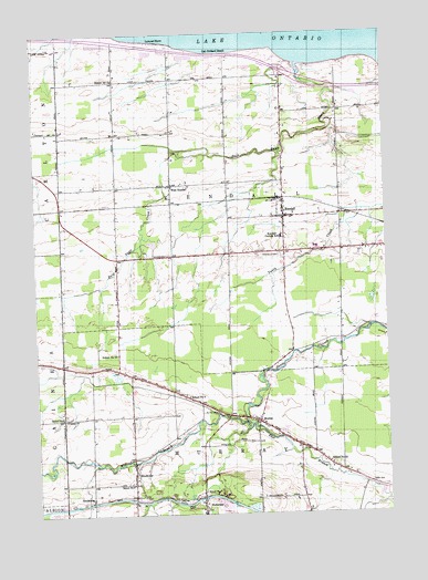
Kendall, NY USGS Topographic Map
Click on map above to begin viewing in our Map Viewer.

This topographic map contains these locations and features:
Feature Name Type Latitude Longitude GNIS ID View Map
Bald Eagle CreekStreamN43.3673°W78.0303°942850View Map
Bald Eagle MarinaLocaleN43.3662°W78.0311°973692View Map
Beechwood CemeteryCemeteryN43.3441°W78.0743°2516239View Map
Billings FarmsLocaleN43.3161°W78.0569°2712212View Map
BrockvillePopulated PlaceN43.2612°W78.0906°944804View Map
Concordia Lutheran ChurchChurchN43.3312°W78.0355°2615810View Map
East Branch Sandy CreekStreamN43.2734°W78.0486°949014View Map
Fancher Hulberton Murray Fire CompanyBuildingN43.2562°W78.0659°2700856View Map
Greenwood CemeteryCemeteryN43.3177°W78.0377°951788View Map
Hatch CemeteryCemeteryN43.2577°W78.0066°952357View Map
Hindsburg Road BridgeBridgeN43.2532°W78.1059°2614919View Map
HinsburgPopulated PlaceN43.2539°W78.1059°973615View Map
HulbertonPopulated PlaceN43.2531°W78.0659°953419View Map
Hulberton CemeteryCemeteryN43.2518°W78.0654°2516237View Map
Hulberton Road BridgeBridgeN43.2544°W78.0663°2614926View Map
KendallPopulated PlaceN43.3273°W78.0359°954488View Map
Kendall Central SchoolSchoolN43.3220°W78.0370°954489View Map
Kendall Fire DepartmentBuildingN43.3263°W78.0356°2701054View Map
Kendall Junior - Senior High SchoolSchoolN43.3192°W78.0249°2669051View Map
Kendall Post OfficePost OfficeN43.3255°W78.0364°2617986View Map
Kludt FarmsLocaleN43.3597°W78.0714°2712209View Map
Locust Grove FarmLocaleN43.3497°W78.0542°2712214View Map
Lomond ShorePopulated PlaceN43.3726°W78.0803°955816View Map
Maynard's AirportAirportN43.3250°W78.0497°978099View Map
MurrayPopulated PlaceN43.2739°W78.0459°958189View Map
Oak Orchard BeachLocaleN43.3698°W78.0595°959143View Map
Radtke FarmsLocaleN43.3150°W78.0094°2712211View Map
Saint Mark's Roman Catholic ChurchChurchN43.3278°W78.0309°2616967View Map
Sample FarmLocaleN43.3194°W78.0647°2712210View Map
Sandy Creek AcademySchoolN43.2652°W78.0269°2669102View Map
Sandy Creek CemeteryCemeteryN43.2764°W78.0605°958194View Map
School Number 11 (historical)SchoolN43.2559°W78.0656°975000View Map
School Number 11 (historical)SchoolN43.3631°W78.0961°975004View Map
School Number 12 (historical)SchoolN43.2634°W78.0211°975043View Map
School Number 13 (historical)SchoolN43.2917°W78.0961°975067View Map
School Number 2 (historical)SchoolN43.2758°W78.0450°2367669View Map
School Number 3 (historical)SchoolN43.2806°W78.0709°975286View Map
School Number 6 (historical)SchoolN43.2578°W78.0909°975505View Map
School Number 6 (historical)SchoolN43.2936°W78.0269°2367670View Map
School Number 9SchoolN43.2753°W78.1161°975658View Map
Silver Creek FarmsLocaleN43.2617°W78.1178°2516701View Map
Town of KendallCivilN43.3312°W78.0546°979114View Map
Town of MurrayCivilN43.2548°W78.0584°979246View Map
Transit CemeteryCemeteryN43.2761°W78.1150°2516238View Map
Transit ChurchChurchN43.2751°W78.1150°967754View Map
Vendetti FarmsLocaleN43.2742°W78.0894°2712174View Map
West Branch Sandy CreekStreamN43.2734°W78.0486°970762View Map
West KendallPopulated PlaceN43.3359°W78.0759°970770View Map
Zingler FarmsLocaleN43.3450°W78.0400°2712213View Map

Note: Coordinates in the location and feature list above are referenced to NAD83 datum.


Copyright (C) 2008-2025 Ryan Niemi / Sunset Dynamics ... All Rights Reserved