TopoQuest Logo
Do you find TopoQuest useful?
Help keep TopoQuest running and adding new maps/features by donating!
Bitcoin:  19c7KJd3qBynnjoSw5npx9KScwjBe4ifkT
Litecoin:  LXs6TkuXGGXo1vDsWCkWVdjQX94eUKd6ui
Home View Maps Find Maps Find Places Resources & Links


Kilchis River, Oregon Topographic Map

USGS Map Title: Kilchis River, OR
USGS Map MRC: 45123E7
DRG (GeoTIFF) Download: o45123e7.tif


Neighboring USGS Topographic Map Quads:


  Nehalem, OR  
45123F8
 

  Foley Peak, OR  
45123F7
 

  Cook Creek, OR  
45123F6
 

  Garibaldi, OR  
45123E8
 

  Kilchis River, OR  
45123E7
 

  Cedar Butte, OR  
45123E6
 

  Netarts, OR  
45123D8
 

  Tillamook, OR  
45123D7
 

  The Peninsula, OR  
45123D6


Map MRC Location:

N46°
W124°
N46°
W123°
H8 H7 H6 H5 H4 H3 H2 H1
G8 G7 G6 G5 G4 G3 G2 G1
F8 F7 F6 F5 F4 F3 F2 F1
E8 E7 E6 E5 E4 E3 E2 E1
D8 D7 D6 D5 D4 D3 D2 D1
C8 C7 C6 C5 C4 C3 C2 C1
B8 B7 B6 B5 B4 B3 B2 B1
A8 A7 A6 A5 A4 A3 A2 A1
N45°
W124°
N45°
W123°

Kilchis River, OR USGS 1:24K Topographic Map Preview:
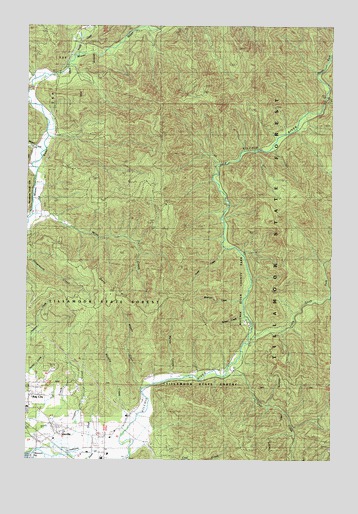
Kilchis River, OR USGS Topographic Map
Click on map above to begin viewing in our Map Viewer.

This topographic map contains these locations and features:
Feature Name Type Latitude Longitude GNIS ID View Map
Aiken CanyonValleyN45.6001°W123.7621°1958487View Map
Averill DairyLocaleN45.5014°W123.8422°2707102View Map
Bay City IOOF CemeteryCemeteryN45.5101°W123.8532°1135198View Map
Blue Star CreekStreamN45.5901°W123.7762°1132392View Map
Clear CreekStreamN45.5243°W123.7943°1139793View Map
Clinton CreekStreamN45.5523°W123.7848°1958488View Map
Coal CreekStreamN45.5012°W123.8329°1139866View Map
Diamond CreekStreamN45.6248°W123.8276°1132169View Map
Dietz CreekStreamN45.5568°W123.7554°1132174View Map
Doty HillSummitN45.5469°W123.8415°1120037View Map
Gilmore CreekStreamN45.5415°W123.7873°1132175View Map
Hathaway SloughStreamN45.5007°W123.8654°1121661View Map
IdavillePopulated PlaceN45.5098°W123.8657°1163061View Map
Idaville Census Designated PlaceCensusN45.5097°W123.8633°2611735View Map
Idaville Post Office (historical)Post OfficeN45.5098°W123.8657°1165428View Map
Iris CreekStreamN45.5387°W123.7679°1132394View Map
Jody CreekStreamN45.5471°W123.7526°1159009View Map
Kilchis River County ParkParkN45.5382°W123.7846°1122725View Map
Kilchis River Park County Drift Boat LaunchLocaleN45.5396°W123.7850°2668246View Map
Kilchis Valley DairyLocaleN45.5097°W123.8367°2707100View Map
Little South Fork Kilchis RiverStreamN45.5351°W123.7851°1123286View Map
Mapes CreekStreamN45.5204°W123.8298°1123739View Map
Mapes Creek County Drift Boat LaunchLocaleN45.5200°W123.8286°2668356View Map
Minich CreekStreamN45.5890°W123.8696°1124238View Map
Moss CreekStreamN45.5704°W123.8724°1124393View Map
Murphy CreekStreamN45.5073°W123.8368°1163170View Map
Myrtle CreekStreamN45.5234°W123.8168°1124577View Map
North Fork Kilchis RiverStreamN45.6043°W123.7543°1163175View Map
Pipe CreekStreamN45.5693°W123.7957°1958490View Map
Prouty CreekStreamN45.6207°W123.8540°1158986View Map
Purcell CreekStreamN45.6112°W123.7571°1958491View Map
Riverdale Post Office (historical)Post OfficeN45.5070°W123.8429°1164634View Map
Riverdale School (historical)SchoolN45.5065°W123.8443°1126062View Map
Roller CreekStreamN45.5601°W123.7893°1958492View Map
Sam Downs CreekStreamN45.5484°W123.7526°1163645View Map
School CreekStreamN45.5401°W123.8012°1132395View Map
Sharp CreekStreamN45.5609°W123.7957°1158987View Map
Shirley CreekStreamN45.5373°W123.7721°1132393View Map
Slide CreekStreamN45.5804°W123.8012°1132396View Map
South Fork Kilchis RiverStreamN45.6043°W123.7543°1163281View Map
Spruce CreekStreamN45.5590°W123.7876°1958495View Map
Stuart CreekStreamN45.6137°W123.8596°1132391View Map
Thomas CreekStreamN45.5248°W123.8082°1132176View Map
Tilden BluffsCliffN45.6054°W123.7953°1132170View Map
Tilton CreekStreamN45.5859°W123.7998°1132172View Map
Turning Point DairyLocaleN45.5022°W123.8511°2707111View Map
Vaughn CreekStreamN45.5029°W123.8676°1163321View Map
Waldron CreekStreamN45.6096°W123.8679°1132390View Map
Washout CreekStreamN45.5457°W123.7873°1158988View Map
Watertank CreekStreamN45.5276°W123.7901°1132398View Map
Whitney CreekStreamN45.5957°W123.7665°1132171View Map
Zigzag CanyonValleyN45.5998°W123.7623°1163644View Map

Note: Coordinates in the location and feature list above are referenced to NAD83 datum.


Copyright (C) 2008-2025 Ryan Niemi / Sunset Dynamics ... All Rights Reserved