TopoQuest Logo
Do you find TopoQuest useful?
Help keep TopoQuest running and adding new maps/features by donating!
Bitcoin:  19c7KJd3qBynnjoSw5npx9KScwjBe4ifkT
Litecoin:  LXs6TkuXGGXo1vDsWCkWVdjQX94eUKd6ui
Home View Maps Find Maps Find Places Resources & Links


Foley Peak, Oregon Topographic Map

USGS Map Title: Foley Peak, OR
USGS Map MRC: 45123F7
DRG (GeoTIFF) Download: o45123f7.tif


Neighboring USGS Topographic Map Quads:


  Arch Cape, OR  
45123G8
 

  Soapstone Lake, OR  
45123G7
 

  Hamlet, OR  
45123G6
 

  Nehalem, OR  
45123F8
 

  Foley Peak, OR  
45123F7
 

  Cook Creek, OR  
45123F6
 

  Garibaldi, OR  
45123E8
 

  Kilchis River, OR  
45123E7
 

  Cedar Butte, OR  
45123E6


Map MRC Location:

N46°
W124°
N46°
W123°
H8 H7 H6 H5 H4 H3 H2 H1
G8 G7 G6 G5 G4 G3 G2 G1
F8 F7 F6 F5 F4 F3 F2 F1
E8 E7 E6 E5 E4 E3 E2 E1
D8 D7 D6 D5 D4 D3 D2 D1
C8 C7 C6 C5 C4 C3 C2 C1
B8 B7 B6 B5 B4 B3 B2 B1
A8 A7 A6 A5 A4 A3 A2 A1
N45°
W124°
N45°
W123°

Foley Peak, OR USGS 1:24K Topographic Map Preview:
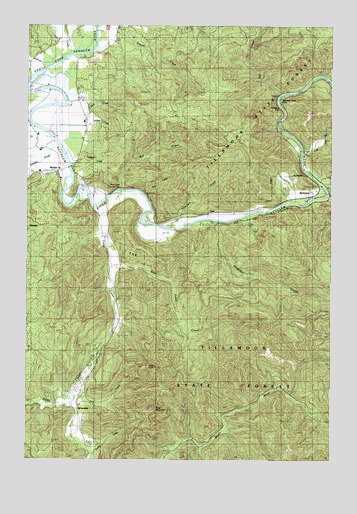
Foley Peak, OR USGS Topographic Map
Click on map above to begin viewing in our Map Viewer.

This topographic map contains these locations and features:
Feature Name Type Latitude Longitude GNIS ID View Map
Adair (historical)LocaleN45.6946°W123.8137°1166477View Map
Anderson CreekStreamN45.6932°W123.7985°1116931View Map
Anderson CreekStreamN45.7371°W123.8676°1116932View Map
Anglersvale (historical)LocaleN45.7026°W123.7568°1162744View Map
Anglersvale Post Office (historical)Post OfficeN45.7015°W123.7554°1164183View Map
Asay DairyLocaleN45.7183°W123.8719°2707106View Map
Badger (historical)LocaleN45.7059°W123.7735°1166479View Map
Balm Post Office (historical)Post OfficeN45.6887°W123.8429°1164876View Map
BarnesdalePopulated PlaceN45.6393°W123.8546°1136033View Map
Barnesdale Post Office (historical)Post OfficeN45.6393°W123.8546°1164885View Map
BattersonPopulated PlaceN45.7012°W123.7585°1136040View Map
Batterson CreekStreamN45.6971°W123.7735°1132168View Map
Blybach Post Office (historical)Post OfficeN45.6971°W123.7915°1164932View Map
Camp NehalemLocaleN45.7165°W123.7679°1159007View Map
Coal CreekStreamN45.7396°W123.8601°1119051View Map
Cook CreekStreamN45.7015°W123.7532°1119216View Map
Craig MountainSummitN45.6457°W123.8207°1132389View Map
Crystal CreekStreamN45.6901°W123.8457°1132387View Map
Dry CreekStreamN45.6484°W123.8540°1132388View Map
East Foley CreekStreamN45.6807°W123.8404°1120292View Map
Fall CreekStreamN45.7301°W123.7729°1120610View Map
Foley (historical)Populated PlaceN45.6582°W123.8415°1132386View Map
Foley (historical)LocaleN45.7032°W123.8490°1166487View Map
Foley CreekStreamN45.6973°W123.8462°1120859View Map
Foley PeakSummitN45.6515°W123.8232°1120863View Map
Foley Post Office (historical)Post OfficeN45.6582°W123.8415°1165262View Map
FossPopulated PlaceN45.6962°W123.7976°1120902View Map
Foss Post Office (historical)Post OfficeN45.6962°W123.7976°1165269View Map
Gallagher SloughGutN45.7109°W123.8690°1121045View Map
Garibaldi Rural Fire DistrictBuildingN45.6525°W123.8507°2577049View Map
Gravel CreekStreamN45.7457°W123.8485°1132743View Map
Kebbe CreekStreamN45.7262°W123.8596°1132384View Map
Knudson (historical)LocaleN45.6929°W123.8318°1162367View Map
Lost CreekStreamN45.7126°W123.7632°1123496View Map
Lynbrook (historical)LocaleN45.6984°W123.7790°1166769View Map
McPherson CreekStreamN45.7040°W123.7540°1132183View Map
MohlerPopulated PlaceN45.7073°W123.8629°1124281View Map
Mohler Post Office (historical)Post OfficeN45.7073°W123.8629°1165651View Map
Mohler Sand and Gravel Boat LaunchLocaleN45.6917°W123.8169°2668100View Map
Nehalem FallsFallsN45.7273°W123.7729°1124639View Map
Nehalem Falls (historical)LocaleN45.7304°W123.7735°1162366View Map
Nehalem Falls CampgroundParkN45.7204°W123.7718°2058161View Map
Nehalem Fish HatcheryLocaleN45.6612°W123.8399°1163745View Map
Pearl CreekStreamN45.7234°W123.8526°1132382View Map
Peterson CreekStreamN45.6923°W123.8101°1125322View Map
Roy CreekStreamN45.7023°W123.8371°1126348View Map
Roy Creek County Park Boat LaunchLocaleN45.7026°W123.8396°2668571View Map
Roy Creek ParkParkN45.7026°W123.8401°1132385View Map
School CreekStreamN45.6932°W123.8304°1158985View Map
Stonehill (historical)LocaleN45.6976°W123.7818°1166504View Map
Upper NehalemLocaleN45.7443°W123.8679°1132404View Map
Zaddach CreekStreamN45.7137°W123.8568°1132383View Map

Note: Coordinates in the location and feature list above are referenced to NAD83 datum.


Copyright (C) 2008-2024 Ryan Niemi / Sunset Dynamics ... All Rights Reserved