TopoQuest Logo
Do you find TopoQuest useful?
Help keep TopoQuest running and adding new maps/features by donating!
Bitcoin:  19c7KJd3qBynnjoSw5npx9KScwjBe4ifkT
Litecoin:  LXs6TkuXGGXo1vDsWCkWVdjQX94eUKd6ui
Home View Maps Find Maps Find Places Resources & Links


Kingwood, Pennsylvania Topographic Map

USGS Map Title: Kingwood, PA
USGS Map MRC: 39079H3
DRG (GeoTIFF) Download: o39079h3.tif


Neighboring USGS Topographic Map Quads:


  Donegal, PA  
40079A4
 

  Seven Springs, PA  
40079A3
 

  Bakersville, PA  
40079A2
 

  Mill Run, PA  
39079H4
 

  Kingwood, PA  
39079H3
 

  Rockwood, PA  
39079H2
 

  Ohiopyle, PA  
39079G4
 

  Confluence, PA  
39079G3
 

  Markleton, PA  
39079G2


Map MRC Location:

N40°
W80°
N40°
W79°
H8 H7 H6 H5 H4 H3 H2 H1
G8 G7 G6 G5 G4 G3 G2 G1
F8 F7 F6 F5 F4 F3 F2 F1
E8 E7 E6 E5 E4 E3 E2 E1
D8 D7 D6 D5 D4 D3 D2 D1
C8 C7 C6 C5 C4 C3 C2 C1
B8 B7 B6 B5 B4 B3 B2 B1
A8 A7 A6 A5 A4 A3 A2 A1
N39°
W80°
N39°
W79°

Kingwood, PA USGS 1:24K Topographic Map Preview:
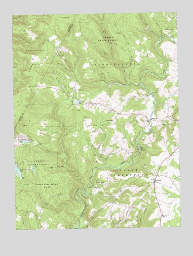
Kingwood, PA USGS Topographic Map
Click on map above to begin viewing in our Map Viewer.

This topographic map contains these locations and features:
Feature Name Type Latitude Longitude GNIS ID View Map
Allen CreekStreamN39.9854°W79.2609°1168181View Map
Ansell RunStreamN39.9676°W79.3273°1168326View Map
Barron Church (historical)ChurchN39.9626°W79.2500°1205295View Map
BarronvalePopulated PlaceN39.9517°W79.2714°1168766View Map
Blue HoleLakeN39.9734°W79.2981°1201343View Map
Blue Hole CreekStreamN39.9590°W79.2845°1169879View Map
Blue Hole SpringSpringN39.9726°W79.2981°1201342View Map
Clairton LakeReservoirN39.9262°W79.3664°1171890View Map
Cole RunStreamN39.9667°W79.2895°1172177View Map
Cole Run FallsFallsN39.9717°W79.2839°1201341View Map
Crab RunStreamN39.9854°W79.2598°1172576View Map
Cranberry Glade DamDamN39.9051°W79.3698°1194415View Map
Cranberry Glade LakeReservoirN39.9107°W79.3748°1172621View Map
Cranberry Glade RunStreamN39.8834°W79.3248°1172622View Map
Fall CreekStreamN39.9592°W79.2775°1174578View Map
Flugey HollowValleyN39.9122°W79.3365°1174921View Map
Garys RunStreamN39.9734°W79.2978°1192504View Map
Green King RunStreamN39.9187°W79.3106°1176082View Map
Harbaugh RunStreamN39.9159°W79.3373°1176494View Map
Harbaugh School (historical)SchoolN39.9184°W79.3645°1205293View Map
Hillview ChurchChurchN39.9909°W79.3556°1205297View Map
King SchoolSchoolN39.8934°W79.3053°1205294View Map
King SchoolSchoolN39.9667°W79.3281°1205296View Map
Kings BridgeLocaleN39.9376°W79.2709°1178487View Map
Kings Mountain Country ClubLocaleN39.9562°W79.3256°1213253View Map
KingwoodPopulated PlaceN39.9015°W79.2686°1178510View Map
Kingwood SchoolSchoolN39.8820°W79.2634°1178511View Map
Lake PyleReservoirN39.9488°W79.3263°1184512View Map
Laural Ridge State ParkParkN39.9667°W79.3548°1196524View Map
Lost CreekStreamN39.9479°W79.2670°1179964View Map
MetzlerPopulated PlaceN39.9206°W79.2789°1180980View Map
Mose King RunStreamN39.9048°W79.3159°1181599View Map
Old Bethel ChurchChurchN39.8895°W79.3003°1182895View Map
Paterson SpringSpringN39.9887°W79.2919°1183359View Map
Sandy RunStreamN39.8976°W79.3234°1186960View Map
SchweibinzvillePopulated PlaceN39.9006°W79.3106°1204593View Map
SculltonPopulated PlaceN39.9479°W79.3128°1187192View Map
Showman RunStreamN39.9670°W79.3267°1187611View Map
Township of MiddlecreekCivilN39.9722°W79.2719°1217055View Map
Township of Upper TurkeyfootCivilN39.8938°W79.2826°1217066View Map
Wesley ChapelChurchN39.9376°W79.2992°1190852View Map
Whipkey DamDamN39.9219°W79.2801°1191231View Map
Whipkey RunStreamN39.9117°W79.3056°1191230View Map

Note: Coordinates in the location and feature list above are referenced to NAD83 datum.


Copyright (C) 2008-2024 Ryan Niemi / Sunset Dynamics ... All Rights Reserved