TopoQuest Logo
Do you find TopoQuest useful?
Help keep TopoQuest running and adding new maps/features by donating!
Bitcoin:  19c7KJd3qBynnjoSw5npx9KScwjBe4ifkT
Litecoin:  LXs6TkuXGGXo1vDsWCkWVdjQX94eUKd6ui
Home View Maps Find Maps Find Places Resources & Links


Seven Springs, Pennsylvania Topographic Map

USGS Map Title: Seven Springs, PA
USGS Map MRC: 40079A3
DRG (GeoTIFF) Download: o40079a3.tif


Neighboring USGS Topographic Map Quads:


  Mammoth, PA  
40079B4
 

  Stahlstown, PA  
40079B3
 

  Ligonier, PA  
40079B2
 

  Donegal, PA  
40079A4
 

  Seven Springs, PA  
40079A3
 

  Bakersville, PA  
40079A2
 

  Mill Run, PA  
39079H4
 

  Kingwood, PA  
39079H3
 

  Rockwood, PA  
39079H2


Map MRC Location:

N41°
W80°
N41°
W79°
H8 H7 H6 H5 H4 H3 H2 H1
G8 G7 G6 G5 G4 G3 G2 G1
F8 F7 F6 F5 F4 F3 F2 F1
E8 E7 E6 E5 E4 E3 E2 E1
D8 D7 D6 D5 D4 D3 D2 D1
C8 C7 C6 C5 C4 C3 C2 C1
B8 B7 B6 B5 B4 B3 B2 B1
A8 A7 A6 A5 A4 A3 A2 A1
N40°
W80°
N40°
W79°

Seven Springs, PA USGS 1:24K Topographic Map Preview:
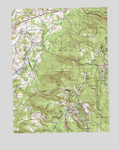
Seven Springs, PA USGS Topographic Map
Click on map above to begin viewing in our Map Viewer.

This topographic map contains these locations and features:
Feature Name Type Latitude Longitude GNIS ID View Map
Beck SpringsSpringN40.0506°W79.2639°1201702View Map
Birch Rock HillSummitN40.0473°W79.3173°1169640View Map
Borough of Seven SpringsCivilN40.0251°W79.2934°1217326View Map
Camp AlliquippaLocaleN40.0665°W79.3428°1170971View Map
Camp RunStreamN40.0981°W79.3303°1171076View Map
Center ChurchChurchN40.0070°W79.2639°1171428View Map
ChampionPopulated PlaceN40.0751°W79.3581°1171546View Map
Champion Post OfficePost OfficeN40.0757°W79.3586°2773095View Map
Clifford N Pritts SchoolSchoolN40.0601°W79.3717°1209256View Map
Donegal SchoolSchoolN40.0998°W79.3578°1173380View Map
Hidden Valley Ski AreaLocaleN40.0581°W79.2573°1213228View Map
HopewellPopulated PlaceN40.0712°W79.3442°1203836View Map
Horners MillPopulated PlaceN40.1092°W79.3148°1203843View Map
Jones MillsPopulated PlaceN40.0887°W79.3406°1178150View Map
Jones Mills Post OfficePost OfficeN40.0877°W79.3381°2772766View Map
Kooser FiretowerTowerN40.0509°W79.2781°1205292View Map
Kooser Run DamDamN40.0567°W79.2581°1194515View Map
Kooser SpringSpringN40.0701°W79.2567°1202320View Map
KregarPopulated PlaceN40.1215°W79.3067°1178679View Map
Laurel Hill State ParkParkN40.0134°W79.2589°1214719View Map
Little RunStreamN40.1204°W79.2898°1179664View Map
Maple GrovePopulated PlaceN40.0620°W79.3698°1180322View Map
Mount Hope ChurchChurchN40.0679°W79.2720°1181714View Map
Mount Nebo ChurchChurchN40.0531°W79.3556°1181759View Map
Mount Olive ChurchChurchN40.1040°W79.3356°1209232View Map
MyersbrookPopulated PlaceN40.0723°W79.2909°1182136View Map
Neals RunStreamN40.0370°W79.3509°1182195View Map
NeboPopulated PlaceN40.0595°W79.3645°1182199View Map
Nedrow CemeteryCemeteryN40.0565°W79.2948°1182208View Map
Painter Rock HillSummitN40.0667°W79.2981°1183203View Map
Pike RunStreamN40.0692°W79.3434°1183728View Map
Pike Run Country ClubLocaleN40.0842°W79.3259°1213325View Map
Roaring RunStreamN40.0734°W79.3581°1185170View Map
Roaring Run Natural AreaParkN40.0654°W79.3061°1209239View Map
Saint Raymonds CemeteryCemeteryN40.0573°W79.3528°1186699View Map
Saint Raymonds ChurchChurchN40.1009°W79.3553°1186700View Map
Seven SpringsPopulated PlaceN40.0231°W79.2973°1204614View Map
Seven Springs Airport (historical)AirportN40.0101°W79.3215°1193801View Map
Seven Springs Mountain ResortLocaleN40.0231°W79.2973°1205820View Map
Seven Springs Resort Golf CourseLocaleN40.0259°W79.2806°1205821View Map
Seven Springs Volunteer Fire Company - Station 625BuildingN40.0243°W79.2988°2645853View Map
Somerset QuarryMineN40.0647°W79.2575°2724970View Map
Spook HillSummitN40.0317°W79.3339°1188188View Map
Township of DonegalCivilN40.1076°W79.3324°1217236View Map
Trout RunStreamN40.0367°W79.3509°1189843View Map
Turquois LakesLakeN40.0266°W79.3552°1212265View Map
White Mountain Ski AreaLocaleN40.0145°W79.3323°1213405View Map

Note: Coordinates in the location and feature list above are referenced to NAD83 datum.


Copyright (C) 2008-2025 Ryan Niemi / Sunset Dynamics ... All Rights Reserved