TopoQuest Logo
Do you find TopoQuest useful?
Help keep TopoQuest running and adding new maps/features by donating!
Bitcoin:  19c7KJd3qBynnjoSw5npx9KScwjBe4ifkT
Litecoin:  LXs6TkuXGGXo1vDsWCkWVdjQX94eUKd6ui
Home View Maps Find Maps Find Places Resources & Links


Barber, Arkansas Topographic Map

USGS Map Title: Barber, AR
USGS Map MRC: 35094B1
DRG (GeoTIFF) Download: o35094b1.tif


Neighboring USGS Topographic Map Quads:


  Lavaca, AR  
35094C2
 

  Charleston, AR  
35094C1
 

  Branch, AR  
35093C8
 

  Burnville, AR  
35094B2
 

  Barber, AR  
35094B1
 

  Booneville, AR  
35093B8
 

  Abbott, AR  
35094A2
 

  Ione, AR  
35094A1
 

  Golden City, AR  
35093A8


Map MRC Location:

N36°
W95°
N36°
W94°
H8 H7 H6 H5 H4 H3 H2 H1
G8 G7 G6 G5 G4 G3 G2 G1
F8 F7 F6 F5 F4 F3 F2 F1
E8 E7 E6 E5 E4 E3 E2 E1
D8 D7 D6 D5 D4 D3 D2 D1
C8 C7 C6 C5 C4 C3 C2 C1
B8 B7 B6 B5 B4 B3 B2 B1
A8 A7 A6 A5 A4 A3 A2 A1
N35°
W95°
N35°
W94°

Barber, AR USGS 1:24K Topographic Map Preview:
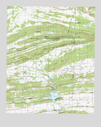
Barber, AR USGS Topographic Map
Click on map above to begin viewing in our Map Viewer.

This topographic map contains these locations and features:
Feature Name Type Latitude Longitude GNIS ID View Map
Antioca CemeteryCemeteryN35.1329°W94.0241°45882View Map
Antioch ChurchChurchN35.1334°W94.0249°64195View Map
Backbone NarrowsGapN35.2220°W94.0374°45998View Map
BarberPopulated PlaceN35.1284°W94.0535°57326View Map
Barber Post Office (historical)Post OfficeN35.1287°W94.0538°84255View Map
Barber RidgeRidgeN35.1340°W94.0585°56669View Map
Bell CemeteryCemeteryN35.1715°W94.1016°56670View Map
Blythe RidgeRidgeN35.1381°W94.0805°46780View Map
Booneville Gas FieldOilfieldN35.1862°W94.0119°64194View Map
Booneville LakeReservoirN35.1479°W94.0599°70389View Map
Bradshaw NarrowsGapN35.2070°W94.0305°46906View Map
Gin CreekStreamN35.1712°W94.0722°49423View Map
GlendalePopulated PlaceN35.1493°W94.0024°64213View Map
Green RidgeRidgeN35.1276°W94.0308°49646View Map
KOLX-FM (Barling)TowerN35.2176°W94.0191°85363View Map
Leon (historical)Populated PlaceN35.2390°W94.0058°63015View Map
Little Washburn CreekStreamN35.1301°W94.0569°72426View Map
Mannuis CemeteryCemeteryN35.1429°W94.0335°51647View Map
Mebane RidgeRidgeN35.1429°W94.0477°51893View Map
Milltown Washburn Fire Department Station 2BuildingN35.1794°W94.1003°2116798View Map
Molly Gap CreekStreamN35.1756°W94.0830°56671View Map
Pigeon CreekStreamN35.1654°W94.0599°53359View Map
Pine HillSummitN35.2448°W94.0158°53434View Map
Pinnacle MountainSummitN35.2137°W94.0533°58391View Map
Pleasant RidgeRidgeN35.1851°W94.0491°53585View Map
Pleasant Ridge CemeteryCemeteryN35.1868°W94.0435°53588View Map
Polecat BranchStreamN35.1290°W94.0477°53657View Map
Rattlesnake NarrowsGapN35.2165°W94.0299°53910View Map
Rebecca Lewis CemeteryCemeteryN35.2112°W94.0608°56672View Map
Sixmile Creek Watershed Site 12 DamDamN35.2284°W94.0102°80613View Map
Sixmile Creek Watershed Site 12 ReservoirReservoirN35.2282°W94.0113°80614View Map
Spencer CemeteryCemeteryN35.2309°W94.0288°55063View Map
Township of WashburnCivilN35.1628°W94.0745°69120View Map
Upper Petit Jean Site Number Nine DamDamN35.1384°W94.0585°81317View Map
Upper Petit Jean Site Number Nine ReservoirReservoirN35.1384°W94.0585°81318View Map
WashburnPopulated PlaceN35.1684°W94.0935°78701View Map
Washburn CemeteryCemeteryN35.1726°W94.1005°56073View Map

Note: Coordinates in the location and feature list above are referenced to NAD83 datum.


Copyright (C) 2008-2024 Ryan Niemi / Sunset Dynamics ... All Rights Reserved