TopoQuest Logo
Do you find TopoQuest useful?
Help keep TopoQuest running and adding new maps/features by donating!
Bitcoin:  19c7KJd3qBynnjoSw5npx9KScwjBe4ifkT
Litecoin:  LXs6TkuXGGXo1vDsWCkWVdjQX94eUKd6ui
Home View Maps Find Maps Find Places Resources & Links


Kitchen Cove, New Mexico Topographic Map

USGS Map Title: Kitchen Cove, NM
USGS Map MRC: 32104C3
DRG (GeoTIFF) Download: o32104c3.tif


Neighboring USGS Topographic Map Quads:


  Azotea Peak, NM  
32104D4
 

  Carlsbad West, NM  
32104D3
 

  Carlsbad East, NM  
32104D2
 

  Carnero Peak, NM  
32104C4
 

  Kitchen Cove, NM  
32104C3
 

  Otis, NM  
32104C2
 

  Carlsbad Caverns, NM  
32104B4
 

  Black River Village, NM  
32104B3
 

  Bond Draw, NM  
32104B2


Map MRC Location:

N33°
W105°
N33°
W104°
H8 H7 H6 H5 H4 H3 H2 H1
G8 G7 G6 G5 G4 G3 G2 G1
F8 F7 F6 F5 F4 F3 F2 F1
E8 E7 E6 E5 E4 E3 E2 E1
D8 D7 D6 D5 D4 D3 D2 D1
C8 C7 C6 C5 C4 C3 C2 C1
B8 B7 B6 B5 B4 B3 B2 B1
A8 A7 A6 A5 A4 A3 A2 A1
N32°
W105°
N32°
W104°

Kitchen Cove, NM USGS 1:24K Topographic Map Preview:
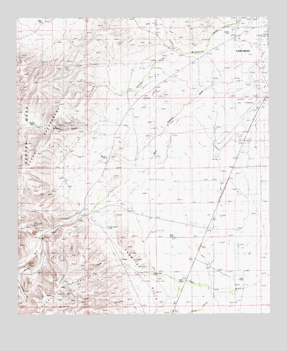
Kitchen Cove, NM USGS Topographic Map
Click on map above to begin viewing in our Map Viewer.

This topographic map contains these locations and features:
Feature Name Type Latitude Longitude GNIS ID View Map
10215 Water WellWellN32.3746°W104.2633°931350View Map
10218 Water WellWellN32.3612°W104.2966°931349View Map
10220 Water WellWellN32.3560°W104.2552°931347View Map
10221 Water WellWellN32.3562°W104.2533°931348View Map
10257 Water WellWellN32.3432°W104.3644°930964View Map
10258 Water WellWellN32.3154°W104.3522°931354View Map
10260 Water WellWellN32.3290°W104.2752°930963View Map
10261 Water WellWellN32.3215°W104.3349°930962View Map
10262 Water WellWellN32.3140°W104.3147°931353View Map
10264 Water WellWellN32.2915°W104.3383°931351View Map
10267 Water WellWellN32.2784°W104.3230°930815View Map
10268 Water WellWellN32.2668°W104.2686°930814View Map
10411 Water WellWellN32.3557°W104.2547°930965View Map
10416 Water WellWellN32.2948°W104.3474°931352View Map
Byrnes TankReservoirN32.3162°W104.3312°887005View Map
Carlsbad Army Air Field (historical)MilitaryN32.3372°W104.2631°2091842View Map
Carlsbad Fire Department Station 6BuildingN32.3460°W104.2514°2658035View Map
Carlsbad PitMineN32.3482°W104.2627°914627View Map
Cavern City Air TerminalAirportN32.3375°W104.2633°936916View Map
Cocke TankReservoirN32.2669°W104.3082°887720View Map
Cueva EscarpmentRidgeN32.3076°W104.3716°888141View Map
Dark CanyonValleyN32.2918°W104.3446°905602View Map
Dark Canyon TankReservoirN32.2854°W104.3291°888200View Map
Dublin TankReservoirN32.3685°W104.2696°888551View Map
Dublin WellWellN32.3598°W104.2977°888552View Map
East TankReservoirN32.2647°W104.2658°888705View Map
Eddy County PitsMineN32.3637°W104.2619°914618View Map
Elbow CanyonValleyN32.2594°W104.2747°888830View Map
Elbow DrawValleyN32.2679°W104.3113°888831View Map
Frontier HillsRangeN32.2669°W104.3119°889249View Map
Juniper CanyonValleyN32.2617°W104.3749°890610View Map
Kee TankReservoirN32.3736°W104.3648°890636View Map
King RanchLocaleN32.2918°W104.2788°890709View Map
Kitchen CoveAreaN32.3326°W104.3683°890729View Map
Little McKittrick DrawValleyN32.3723°W104.2588°898365View Map
Lovejoy RanchLocaleN32.3018°W104.2755°891404View Map
Maverick CanyonValleyN32.2564°W104.3170°898377View Map
Mosley CanyonValleyN32.2776°W104.3647°897416View Map
Sheep DrawValleyN32.3612°W104.2938°894774View Map
South TankReservoirN32.2637°W104.2935°895132View Map
West TankReservoirN32.2827°W104.2979°896414View Map
Yellow Jacket SpringSpringN32.2879°W104.3644°896814View Map

Note: Coordinates in the location and feature list above are referenced to NAD83 datum.


Copyright (C) 2008-2024 Ryan Niemi / Sunset Dynamics ... All Rights Reserved