TopoQuest Logo
Do you find TopoQuest useful?
Help keep TopoQuest running and adding new maps/features by donating!
Bitcoin:  19c7KJd3qBynnjoSw5npx9KScwjBe4ifkT
Litecoin:  LXs6TkuXGGXo1vDsWCkWVdjQX94eUKd6ui
Home View Maps Find Maps Find Places Resources & Links


Krotz Springs, Louisiana Topographic Map

USGS Map Title: Krotz Springs, LA
USGS Map MRC: 30091E7
DRG (GeoTIFF) Download: o30091e7.tif


Neighboring USGS Topographic Map Quads:


  Palmetto, LA  
30091F8
 

  Swayze Lake, LA  
30091F7
 

  Melville, LA  
30091F6
 

  Port Barre, LA  
30091E8
 

  Krotz Springs, LA  
30091E7
 

  Lottie, LA  
30091E6
 

  Arnaudville, LA  
30091D8
 

  Portage, LA  
30091D7
 

  Maringouin NW, LA  
30091D6


Map MRC Location:

N31°
W92°
N31°
W91°
H8 H7 H6 H5 H4 H3 H2 H1
G8 G7 G6 G5 G4 G3 G2 G1
F8 F7 F6 F5 F4 F3 F2 F1
E8 E7 E6 E5 E4 E3 E2 E1
D8 D7 D6 D5 D4 D3 D2 D1
C8 C7 C6 C5 C4 C3 C2 C1
B8 B7 B6 B5 B4 B3 B2 B1
A8 A7 A6 A5 A4 A3 A2 A1
N30°
W92°
N30°
W91°

Krotz Springs, LA USGS 1:24K Topographic Map Preview:
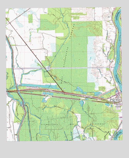
Krotz Springs, LA USGS Topographic Map
Click on map above to begin viewing in our Map Viewer.

This topographic map contains these locations and features:
Feature Name Type Latitude Longitude GNIS ID View Map
Adams BayouStreamN30.5146°W91.7982°559754View Map
Bayou Big GrawStreamN30.5146°W91.7843°559871View Map
Bayou ChenevertStreamN30.5130°W91.8712°559902View Map
Bayou Courtableau Gas FieldOilfieldN30.5366°W91.8418°1628729View Map
Bayou Courtableau Outlet ChannelCanalN30.5041°W91.8493°559918View Map
Big Bayou De GrasseStreamN30.5057°W91.7921°560166View Map
Big Darbonne BayouStreamN30.6077°W91.8748°560179View Map
Brushy BayouStreamN30.5669°W91.8276°560286View Map
Close LakeLakeN30.5283°W91.8072°560443View Map
Cowan BayLakeN30.5320°W91.8288°560512View Map
Craft LakeLakeN30.5144°W91.8002°560524View Map
Darbonne BayStreamN30.5488°W91.8737°560581View Map
First Baptist ChurchChurchN30.5389°W91.7606°2601740View Map
First United Pentecostal ChurchChurchN30.5363°W91.7561°2601998View Map
Half Moon BayouStreamN30.5432°W91.7896°560927View Map
Krotz SpringsPopulated PlaceN30.5369°W91.7529°1627411View Map
Krotz Springs Elementary SchoolSchoolN30.5379°W91.7561°552618View Map
Krotz Springs Head Start Center SchoolSchoolN30.5313°W91.7536°2600229View Map
Krotz Springs Police DepartmentBuildingN30.5381°W91.7533°2333998View Map
Krotz Springs School (historical)SchoolN30.5521°W91.7576°1628734View Map
Krotz Springs Wastewater Treatment PlantLocaleN30.5472°W91.7559°2603452View Map
Latania BayouLakeN30.5438°W91.7676°1628735View Map
Little State CanalCanalN30.5435°W91.8051°1628736View Map
Mary Cane LakeLakeN30.5137°W91.7805°1627620View Map
McClurePopulated PlaceN30.5474°W91.8321°552625View Map
Midway CemeteryCemeteryN30.6163°W91.7604°1627654View Map
New Darbonne (historical)Populated PlaceN30.6113°W91.8709°1628739View Map
Parish Governing Authority District 6CivilN30.5041°W91.8558°1930155View Map
Saint Anthony ChurchChurchN30.5373°W91.7573°2602602View Map
Saint Landry Parish Fire District 1BuildingN30.5379°W91.7534°2332606View Map
Sandy BayouStreamN30.6155°W91.8132°1628173View Map
State CanalCanalN30.6066°W91.8073°1628293View Map
Threemile BayouStreamN30.5744°W91.7787°1628361View Map
Town of Krotz SpringsCivilN30.5323°W91.7518°2405960View Map
Two O'clock BayouStreamN30.5655°W91.8334°1628398View Map
Twomile BayouStreamN30.5713°W91.7782°1628399View Map

Note: Coordinates in the location and feature list above are referenced to NAD83 datum.


Copyright (C) 2008-2024 Ryan Niemi / Sunset Dynamics ... All Rights Reserved