TopoQuest Logo
Do you find TopoQuest useful?
Help keep TopoQuest running and adding new maps/features by donating!
Bitcoin:  19c7KJd3qBynnjoSw5npx9KScwjBe4ifkT
Litecoin:  LXs6TkuXGGXo1vDsWCkWVdjQX94eUKd6ui
Home View Maps Find Maps Find Places Resources & Links


Palmetto, Louisiana Topographic Map

USGS Map Title: Palmetto, LA
USGS Map MRC: 30091F8
DRG (GeoTIFF) Download: o30091f8.tif


Neighboring USGS Topographic Map Quads:


  Morrow, LA  
30092G1
 

  Bayou Jack, LA  
30091G8
 

  Bayou Current, LA  
30091G7
 

  Beggs, LA  
30092F1
 

  Palmetto, LA  
30091F8
 

  Swayze Lake, LA  
30091F7
 

  Opelousas, LA  
30092E1
 

  Port Barre, LA  
30091E8
 

  Krotz Springs, LA  
30091E7


Map MRC Location:

N31°
W92°
N31°
W91°
H8 H7 H6 H5 H4 H3 H2 H1
G8 G7 G6 G5 G4 G3 G2 G1
F8 F7 F6 F5 F4 F3 F2 F1
E8 E7 E6 E5 E4 E3 E2 E1
D8 D7 D6 D5 D4 D3 D2 D1
C8 C7 C6 C5 C4 C3 C2 C1
B8 B7 B6 B5 B4 B3 B2 B1
A8 A7 A6 A5 A4 A3 A2 A1
N30°
W92°
N30°
W91°

Palmetto, LA USGS 1:24K Topographic Map Preview:
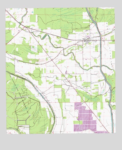
Palmetto, LA USGS Topographic Map
Click on map above to begin viewing in our Map Viewer.

This topographic map contains these locations and features:
Feature Name Type Latitude Longitude GNIS ID View Map
BatPopulated PlaceN30.7169°W91.8982°559826View Map
BoldenPopulated PlaceN30.6788°W91.9309°560243View Map
DanksPopulated PlaceN30.7171°W91.8782°560579View Map
Dick BayouStreamN30.6705°W91.8809°560628View Map
East Prong BayouStreamN30.6602°W91.9029°560695View Map
Goudeau CemeteryCemeteryN30.7196°W91.9498°560855View Map
ImmaculataPopulated PlaceN30.7249°W91.9709°552614View Map
Immaculate Conception ChurchChurchN30.7260°W91.9701°1628732View Map
Immaculate Conception SchoolSchoolN30.7266°W91.9696°1627320View Map
LebeauPopulated PlaceN30.7313°W91.9771°1627463View Map
Lebeau Post OfficePost OfficeN30.7266°W91.9723°1631985View Map
Little Wauksha BayouStreamN30.6294°W91.9884°1627541View Map
McBride CemeteryCemeteryN30.7116°W91.9465°1627627View Map
New Jerusalem ChurchChurchN30.6949°W91.9646°1627765View Map
New Pilgrim Baptist ChurchChurchN30.6905°W91.9029°2602478View Map
North Central High SchoolSchoolN30.7277°W91.9845°2493370View Map
PalmettoPopulated PlaceN30.7174°W91.9093°1627858View Map
Palmetto Elementary SchoolSchoolN30.7142°W91.9115°552645View Map
Palmetto Gas FieldOilfieldN30.7082°W91.8807°552646View Map
Palmetto Post OfficePost OfficeN30.7171°W91.9043°1631995View Map
Palmetto SchoolSchoolN30.6710°W91.9109°1627859View Map
Palmetto Volunteer Fire DepartmentBuildingN30.7171°W91.9043°2691771View Map
Parish Governing Authority District 5CivilN30.7161°W91.9441°1930099View Map
Rideau SettlementPopulated PlaceN30.6838°W91.9034°1628056View Map
Sacred Heart ChurchChurchN30.6932°W91.9171°1628090View Map
Saint James ChurchChurchN30.6830°W91.9812°1628118View Map
Saint John ChurchChurchN30.6719°W91.9246°1628126View Map
Saint Landry Parish Fire District 2BuildingN30.6567°W91.9519°2691737View Map
Saint Matthews Baptist ChurchChurchN30.7170°W91.9122°2602719View Map
Saint Pauls ChurchChurchN30.6582°W91.9534°1628149View Map
Sanctified ChurchChurchN30.7135°W91.9209°1628170View Map
Thistlethwaite State Wildlife Management AreaParkN30.6580°W91.9968°1628351View Map
Tri Community Nursing CenterBuildingN30.6994°W91.9469°2601150View Map
Village of PalmettoCivilN30.7177°W91.9082°2407518View Map
Ward FourCivilN30.6463°W91.8784°1628607View Map
WaxiaPopulated PlaceN30.6655°W91.9590°1628454View Map

Note: Coordinates in the location and feature list above are referenced to NAD83 datum.


Copyright (C) 2008-2025 Ryan Niemi / Sunset Dynamics ... All Rights Reserved