TopoQuest Logo
Do you find TopoQuest useful?
Help keep TopoQuest running and adding new maps/features by donating!
Bitcoin:  19c7KJd3qBynnjoSw5npx9KScwjBe4ifkT
Litecoin:  LXs6TkuXGGXo1vDsWCkWVdjQX94eUKd6ui
Home View Maps Find Maps Find Places Resources & Links


La Cinta Canyon, New Mexico Topographic Map

USGS Map Title: La Cinta Canyon, NM
USGS Map MRC: 35104G2
DRG (GeoTIFF) Download: o35104g2.tif


Neighboring USGS Topographic Map Quads:


  Beaver Canyon, NM  
35104H3
 

  Roy, NM  
35104H2
 

  Kansas Valley Lake, NM  
35104H1
 

  Canon Encierro, NM  
35104G3
 

  La Cinta Canyon, NM  
35104G2
 

  Solano, NM  
35104G1
 

  Arroyo Alamocito, NM  
35104F3
 

  Montoya Point, NM  
35104F2
 

  Waggoner Ranch, NM  
35104F1


Map MRC Location:

N36°
W105°
N36°
W104°
H8 H7 H6 H5 H4 H3 H2 H1
G8 G7 G6 G5 G4 G3 G2 G1
F8 F7 F6 F5 F4 F3 F2 F1
E8 E7 E6 E5 E4 E3 E2 E1
D8 D7 D6 D5 D4 D3 D2 D1
C8 C7 C6 C5 C4 C3 C2 C1
B8 B7 B6 B5 B4 B3 B2 B1
A8 A7 A6 A5 A4 A3 A2 A1
N35°
W105°
N35°
W104°

La Cinta Canyon, NM USGS 1:24K Topographic Map Preview:
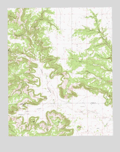
La Cinta Canyon, NM USGS Topographic Map
Click on map above to begin viewing in our Map Viewer.

This topographic map contains these locations and features:
Feature Name Type Latitude Longitude GNIS ID View Map
Apache PointSummitN35.7953°W104.1791°885840View Map
Archuleta CanyonValleyN35.8256°W104.2391°898230View Map
Burro CreekStreamN35.7587°W104.1353°902190View Map
CampseyLocaleN35.8609°W104.1705°924303View Map
Caņon BestiasValleyN35.8228°W104.2158°885477View Map
Caņon de LibradorValleyN35.8489°W104.2280°897759View Map
Caņon GatoValleyN35.7939°W104.2125°897809View Map
Caņon LavirgnValleyN35.8506°W104.1405°897823View Map
Caņon PonienteValleyN35.7803°W104.1983°897839View Map
Caņon ToroValleyN35.8111°W104.2164°897847View Map
Deer MountainSummitN35.7631°W104.1919°888300View Map
Farmers CanyonValleyN35.7803°W104.1983°888974View Map
FlatironSummitN35.7584°W104.1664°889086View Map
Flatiron CanyonValleyN35.7625°W104.1728°889087View Map
Gato PointSummitN35.7870°W104.2061°889377View Map
Hells CanyonValleyN35.8470°W104.2219°889888View Map
Kelly CemeteryCemeteryN35.8375°W104.1677°890651View Map
Kicking Foot MesaSummitN35.8114°W104.1908°890685View Map
KiddLocaleN35.7870°W104.1944°924559View Map
La Cinta CanyonValleyN35.7775°W104.1836°890784View Map
LaumbachLocaleN35.8289°W104.1533°924561View Map
Lucero CanyonValleyN35.8623°W104.2361°891467View Map
MartinesLocaleN35.8709°W104.1325°924564View Map
Morris CanyonValleyN35.8214°W104.2080°892238View Map
Porter CanyonValleyN35.8403°W104.1330°893419View Map
PrichardLocaleN35.8670°W104.1875°924717View Map
Red Tongue MesaSummitN35.7803°W104.1330°893819View Map
RileyLocaleN35.8359°W104.1825°924718View Map
School Section DrawValleyN35.8256°W104.1269°894633View Map
Shannon CanyonValleyN35.8656°W104.1466°894754View Map
Turkey HeadSummitN35.7642°W104.2214°895908View Map
Wright CanyonValleyN35.8325°W104.2494°896778View Map
Wright Springs WindmillLocaleN35.7714°W104.2330°896779View Map

Note: Coordinates in the location and feature list above are referenced to NAD83 datum.


Copyright (C) 2008-2025 Ryan Niemi / Sunset Dynamics ... All Rights Reserved