TopoQuest Logo
Do you find TopoQuest useful?
Help keep TopoQuest running and adding new maps/features by donating!
Bitcoin:  19c7KJd3qBynnjoSw5npx9KScwjBe4ifkT
Litecoin:  LXs6TkuXGGXo1vDsWCkWVdjQX94eUKd6ui
Home View Maps Find Maps Find Places Resources & Links


La Costa Valley, California Topographic Map

USGS Map Title: La Costa Valley, CA
USGS Map MRC: 37121E7
DRG (GeoTIFF) Download: o37121e7.tif


Neighboring USGS Topographic Map Quads:


  Dublin, CA  
37121F8
 

  Livermore, CA  
37121F7
 

  Altamont, CA  
37121F6
 

  Niles, CA  
37121E8
 

  La Costa Valley, CA  
37121E7
 

  Mendenhall Springs, CA  
37121E6
 

  Milpitas, CA  
37121D8
 

  Calaveras Reservoir, CA  
37121D7
 

  Mount Day, CA  
37121D6


Map MRC Location:

N38°
W122°
N38°
W121°
H8 H7 H6 H5 H4 H3 H2 H1
G8 G7 G6 G5 G4 G3 G2 G1
F8 F7 F6 F5 F4 F3 F2 F1
E8 E7 E6 E5 E4 E3 E2 E1
D8 D7 D6 D5 D4 D3 D2 D1
C8 C7 C6 C5 C4 C3 C2 C1
B8 B7 B6 B5 B4 B3 B2 B1
A8 A7 A6 A5 A4 A3 A2 A1
N37°
W122°
N37°
W121°

La Costa Valley, CA USGS 1:24K Topographic Map Preview:
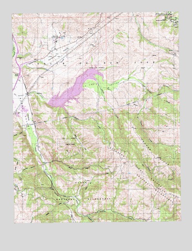
La Costa Valley, CA USGS Topographic Map
Click on map above to begin viewing in our Map Viewer.

This topographic map contains these locations and features:
Feature Name Type Latitude Longitude GNIS ID View Map
Apperson CreekStreamN37.5635°W121.8333°218316View Map
Apperson RidgeRidgeN37.5355°W121.7908°218317View Map
Arroyo Del Valle SanatoriumHospitalN37.6174°W121.7536°1732460View Map
Calaveras CreekStreamN37.5035°W121.8213°254688View Map
Coal Mine CanyonValleyN37.5322°W121.8264°2124658View Map
East Bay Regional Park District Ambulance Station 4BuildingN37.5149°W121.8311°2662306View Map
Exit 21ACrossingN37.5878°W121.8711°2107528View Map
Exit 21BCrossingN37.5922°W121.8703°2107529View Map
Exit 22CrossingN37.6022°W121.8719°2107530View Map
Haynes GulchValleyN37.5344°W121.8541°225064View Map
Indian CreekStreamN37.5849°W121.8122°225864View Map
Indian Joe CreekStreamN37.5141°W121.8283°225886View Map
Jacobs ValleyValleyN37.5075°W121.8033°2124659View Map
James H Turner DamDamN37.5732°W121.8488°226125View Map
La Costa CreekStreamN37.5774°W121.7747°254861View Map
La Costa ValleyValleyN37.5769°W121.8661°226702View Map
Leyden CreekStreamN37.5088°W121.8280°244775View Map
Maguire PeaksSummitN37.5460°W121.8352°227946View Map
San Antonio CreekStreamN37.5749°W121.8727°1654950View Map
San Antonio ReservoirReservoirN37.5798°W121.8290°232370View Map
Scotts CornerPopulated PlaceN37.5888°W121.8711°1659615View Map
South Fork Apperson CreekStreamN37.5627°W121.8325°234963View Map
Sunol Valley Regional ParkParkN37.5285°W121.8208°235798View Map
Vallecitos Atomic LaboratoryBuildingN37.6091°W121.8430°236962View Map
Vallecitos ValleyValleyN37.5947°W121.8669°236949View Map
Vista GrandeSummitN37.5297°W121.8111°2124657View Map
Wauhab RidgeRidgeN37.5333°W121.7594°237367View Map
Williams GulchValleyN37.5749°W121.7694°237847View Map

Note: Coordinates in the location and feature list above are referenced to NAD83 datum.


Copyright (C) 2008-2025 Ryan Niemi / Sunset Dynamics ... All Rights Reserved