TopoQuest Logo
Do you find TopoQuest useful?
Help keep TopoQuest running and adding new maps/features by donating!
Bitcoin:  19c7KJd3qBynnjoSw5npx9KScwjBe4ifkT
Litecoin:  LXs6TkuXGGXo1vDsWCkWVdjQX94eUKd6ui
Home View Maps Find Maps Find Places Resources & Links


La Crosse, Kansas Topographic Map

USGS Map Title: La Crosse, KS
USGS Map MRC: 38099E3
DRG (GeoTIFF) Download: o38099e3.tif


Neighboring USGS Topographic Map Quads:


  La Crosse NW, KS  
38099F4
 

  Liebenthal, KS  
38099F3
 

  Pfeifer, KS  
38099F2
 

  Hargrave, KS  
38099E4
 

  La Crosse, KS  
38099E3
 

  Bison, KS  
38099E2
 

  Nekoma, KS  
38099D4
 

  Rush Center, KS  
38099D3
 

  Timken, KS  
38099D2


Map MRC Location:

N39°
W100°
N39°
W99°
H8 H7 H6 H5 H4 H3 H2 H1
G8 G7 G6 G5 G4 G3 G2 G1
F8 F7 F6 F5 F4 F3 F2 F1
E8 E7 E6 E5 E4 E3 E2 E1
D8 D7 D6 D5 D4 D3 D2 D1
C8 C7 C6 C5 C4 C3 C2 C1
B8 B7 B6 B5 B4 B3 B2 B1
A8 A7 A6 A5 A4 A3 A2 A1
N38°
W100°
N38°
W99°

La Crosse, KS USGS 1:24K Topographic Map Preview:
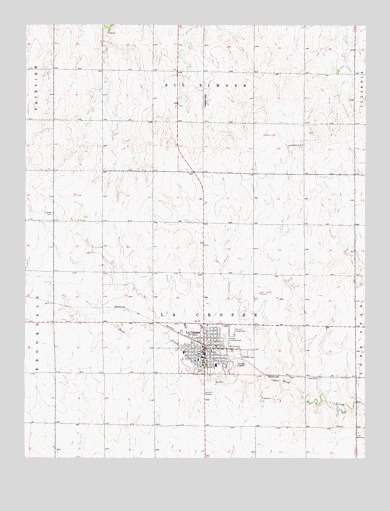
La Crosse, KS USGS Topographic Map
Click on map above to begin viewing in our Map Viewer.

This topographic map contains these locations and features:
Feature Name Type Latitude Longitude GNIS ID View Map
Barbed Wire MuseumBuildingN38.5246°W99.3113°2694256View Map
Barnard LibraryBuildingN38.5289°W99.3113°2694706View Map
Central Rush County Emergency Medical ServicesBuildingN38.5315°W99.3106°2696560View Map
City of La CrosseCivilN38.5319°W99.3094°2395563View Map
First Christian ChurchChurchN38.5295°W99.3124°2690739View Map
First Lutheran ChurchChurchN38.5263°W99.3070°2690742View Map
Friends CemeteryCemeteryN38.5704°W99.3653°475490View Map
Grass ParkParkN38.5250°W99.3115°475487View Map
Hoover Landing Field (historical)AirportN38.5383°W99.3007°475486View Map
Kansas Highway Patrol Troop E RushBuildingN38.5302°W99.3114°2504273View Map
La CrossePopulated PlaceN38.5314°W99.3087°475488View Map
La Crosse CemeteryCemeteryN38.5304°W99.2944°475484View Map
La Crosse City HallBuildingN38.5343°W99.3103°2693107View Map
La Crosse Country ClubLocaleN38.5226°W99.3062°2694575View Map
La Crosse Municipal Power PlantLocaleN38.5318°W99.3085°2692439View Map
La Crosse Police DepartmentBuildingN38.5340°W99.3099°2503998View Map
La Crosse Post OfficePost OfficeN38.5309°W99.3087°2693808View Map
La Crosse Seventh Day Adventist ChurchChurchN38.5310°W99.3070°2690273View Map
La Crosse United Methodist ChurchChurchN38.5258°W99.3056°2689462View Map
La Crosse Wastewater Treatment FacilityLocaleN38.5274°W99.2951°2692059View Map
Lacrosse Elementary SchoolSchoolN38.5284°W99.3117°2497562View Map
Lacrosse High SchoolSchoolN38.5267°W99.3053°480694View Map
Lacrosse Middle SchoolSchoolN38.5271°W99.3050°2720289View Map
Lippard (historical)LocaleN38.6153°W99.3093°482543View Map
Mule CreekStreamN38.5242°W99.3026°475489View Map
Nekoma Bank MuseumBuildingN38.5245°W99.3123°2692694View Map
New Covenant FellowshipChurchN38.5309°W99.3077°2689726View Map
Post Rock MuseumBuildingN38.5246°W99.3120°2694257View Map
Rush CountyCivilN38.5232°W99.3092°485358View Map
Rush County AirportAirportN38.5467°W99.2908°481366View Map
Rush County CourthouseBuildingN38.5301°W99.3115°2625136View Map
Rush County FairgroundsLocaleN38.5367°W99.2984°480693View Map
Rush County Fire District 4 La CrosseBuildingN38.5335°W99.3093°2111805View Map
Rush County Health DepartmentBuildingN38.5293°W99.3090°2695057View Map
Rush County Historical MuseumBuildingN38.5246°W99.3117°2692695View Map
Rush County Memorial HospitalHospitalN38.5306°W99.3170°2499074View Map
Rush County Sheriff's OfficeBuildingN38.5302°W99.3114°2503814View Map
Saint Michael's Catholic ChurchChurchN38.5324°W99.3054°2690804View Map
Saint Michaels CemeteryCemeteryN38.5307°W99.2965°475485View Map
Sixty Plus Senior CenterBuildingN38.5299°W99.3094°2692889View Map
Township of La Crosse-BrookdaleCivilN38.5314°W99.3645°475615View Map

Note: Coordinates in the location and feature list above are referenced to NAD83 datum.


Copyright (C) 2008-2025 Ryan Niemi / Sunset Dynamics ... All Rights Reserved