TopoQuest Logo
Do you find TopoQuest useful?
Help keep TopoQuest running and adding new maps/features by donating!
Bitcoin:  19c7KJd3qBynnjoSw5npx9KScwjBe4ifkT
Litecoin:  LXs6TkuXGGXo1vDsWCkWVdjQX94eUKd6ui
Home View Maps Find Maps Find Places Resources & Links


La Grange East, Texas Topographic Map

USGS Map Title: La Grange East, TX
USGS Map MRC: 29096H7
DRG (GeoTIFF) Download: o29096h7.tif


Neighboring USGS Topographic Map Quads:


  Warda, TX  
30096A8
 

  Nechanitz, TX  
30096A7
 

  Round Top, TX  
30096A6
 

  La Grange West, TX  
29096H8
 

  La Grange East, TX  
29096H7
 

  Fayetteville, TX  
29096H6
 

  Swiss Alp, TX  
29096G8
 

  Ammannsville, TX  
29096G7
 

  Ellinger, TX  
29096G6


Map MRC Location:

N30°
W97°
N30°
W96°
H8 H7 H6 H5 H4 H3 H2 H1
G8 G7 G6 G5 G4 G3 G2 G1
F8 F7 F6 F5 F4 F3 F2 F1
E8 E7 E6 E5 E4 E3 E2 E1
D8 D7 D6 D5 D4 D3 D2 D1
C8 C7 C6 C5 C4 C3 C2 C1
B8 B7 B6 B5 B4 B3 B2 B1
A8 A7 A6 A5 A4 A3 A2 A1
N29°
W97°
N29°
W96°

La Grange East, TX USGS 1:24K Topographic Map Preview:
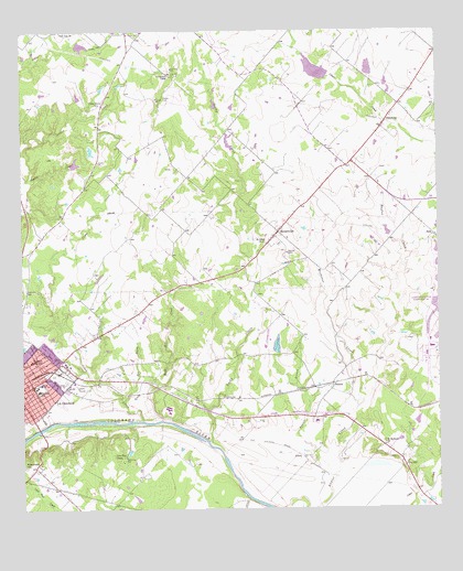
La Grange East, TX USGS Topographic Map
Click on map above to begin viewing in our Map Viewer.

This topographic map contains these locations and features:
Feature Name Type Latitude Longitude GNIS ID View Map
Air Evac 47BuildingN29.9145°W96.8731°2655995View Map
Blue BranchStreamN29.9024°W96.8441°1352441View Map
Cedar CreekStreamN29.8983°W96.8386°1354048View Map
Cedar Grove ChurchChurchN29.9813°W96.8508°1354095View Map
Farmers Industries DamDamN29.9652°W96.8603°1857990View Map
Farmers Industries LakeReservoirN29.9658°W96.8592°1857991View Map
Fayette County Emergency Medical ServicesBuildingN29.9148°W96.8726°2656068View Map
Fayette Heritage Museum and ArchivesBuildingN29.8991°W96.8722°2014146View Map
Gay HillPopulated PlaceN29.8866°W96.7605°1379827View Map
Gravelly BranchStreamN29.8841°W96.7819°1358336View Map
HalstedPopulated PlaceN29.9074°W96.7816°1379883View Map
Henry L Kreische Brewery and HouseBuildingN29.8891°W96.8719°2031072View Map
Hermes Elementary SchoolSchoolN29.9066°W96.8691°2005812View Map
Hermes SchoolSchoolN29.9063°W96.8703°1359075View Map
High Hill CreekStreamN29.8983°W96.8319°1359151View Map
JoinerPopulated PlaceN29.8888°W96.7905°1380009View Map
KBUK-FM (La Grange)TowerN29.8827°W96.8664°1385905View Map
Kiest Branch LibraryBuildingN29.8991°W96.8036°2014896View Map
KVLG-AM (La Grange)TowerN29.8830°W96.8661°1385608View Map
La Grange High SchoolSchoolN29.9019°W96.8653°2005813View Map
La Grange Intermediate SchoolSchoolN29.9086°W96.8694°2005814View Map
La Grange Magnetic StationLocaleN29.9080°W96.8705°1384589View Map
La Grange Middle SchoolSchoolN29.9094°W96.8700°2005815View Map
La Grange Police DepartmentBuildingN29.9086°W96.8671°2739275View Map
Lake ChapparalReservoirN29.9966°W96.8572°1857993View Map
Lake Chapparal DamDamN29.9969°W96.8586°1857992View Map
Lester ParkParkN29.9130°W96.8680°2028925View Map
Lone Star CampLocaleN29.8888°W96.8447°1361662View Map
Lower Colorado River Authority - Fayette Power ProjectBuildingN29.9044°W96.7547°2655825View Map
Lutherhill CampLocaleN29.9883°W96.8280°1361982View Map
Martin Luther King, Junior LibraryBuildingN29.9027°W96.7608°2014863View Map
Moore CemeteryCemeteryN29.9831°W96.8317°1363100View Map
N W Faison Home and MuseumBuildingN29.8991°W96.8725°2014147View Map
North Oak Cliff Branch LibraryBuildingN29.9538°W96.8269°2014836View Map
Oak Lawn Branch LibraryBuildingN29.9641°W96.8125°2014840View Map
OldenburgPopulated PlaceN29.9766°W96.7650°1364511View Map
ParkLocaleN29.9469°W96.7514°1364814View Map
ParkPopulated PlaceN29.9458°W96.7508°2034753View Map
Park Forest Branch LibraryBuildingN29.9822°W96.8619°2014847View Map
Post Oak ChurchChurchN29.9999°W96.8628°1365641View Map
Randolph High SchoolSchoolN29.9141°W96.8722°1366006View Map
Rocky CreekStreamN29.8930°W96.8186°1366753View Map
Rocky Creek Ranch AirportAirportN29.9198°W96.8009°1387037View Map
Rocky Creek Ranch LakeReservoirN29.9181°W96.7987°1865411View Map
Rocky Creek Ranch Lake DamDamN29.9152°W96.7986°1865410View Map
RutersvillePopulated PlaceN29.9477°W96.7972°1367054View Map
Saint James Episcopal ChurchChurchN29.9080°W96.8739°2032232View Map
Saint Johns ChurchChurchN29.9449°W96.8014°1367182View Map
Saint Matthews ChurchChurchN29.8922°W96.7664°1367277View Map
Soil Conservation Service Site 21 DamDamN29.9886°W96.7819°1857988View Map
Soil Conservation Service Site 21 ReservoirReservoirN29.9902°W96.7863°1857989View Map
Soil Conservation Service Site 22 DamDamN29.9886°W96.7703°1857986View Map
Soil Conservation Service Site 22 ReservoirReservoirN29.9907°W96.7705°1857987View Map
Texas Forest Service - LaGrange OfficeBuildingN29.9075°W96.8602°2552570View Map
Thunderbird Southwest AirportAirportN29.9008°W96.7924°2675893View Map
Wertzner CreekStreamN29.9019°W96.7744°1371044View Map

Note: Coordinates in the location and feature list above are referenced to NAD83 datum.


Copyright (C) 2008-2024 Ryan Niemi / Sunset Dynamics ... All Rights Reserved