TopoQuest Logo
Do you find TopoQuest useful?
Help keep TopoQuest running and adding new maps/features by donating!
Bitcoin:  19c7KJd3qBynnjoSw5npx9KScwjBe4ifkT
Litecoin:  LXs6TkuXGGXo1vDsWCkWVdjQX94eUKd6ui
Home View Maps Find Maps Find Places Resources & Links


Ellinger, Texas Topographic Map

USGS Map Title: Ellinger, TX
USGS Map MRC: 29096G6
DRG (GeoTIFF) Download: o29096g6.tif


Neighboring USGS Topographic Map Quads:


  La Grange East, TX  
29096H7
 

  Fayetteville, TX  
29096H6
 

  Industry, TX  
29096H5
 

  Ammannsville, TX  
29096G7
 

  Ellinger, TX  
29096G6
 

  Frelsburg, TX  
29096G5
 

  Weimar, TX  
29096F7
 

  Borden, TX  
29096F6
 

  Columbus, TX  
29096F5


Map MRC Location:

N30°
W97°
N30°
W96°
H8 H7 H6 H5 H4 H3 H2 H1
G8 G7 G6 G5 G4 G3 G2 G1
F8 F7 F6 F5 F4 F3 F2 F1
E8 E7 E6 E5 E4 E3 E2 E1
D8 D7 D6 D5 D4 D3 D2 D1
C8 C7 C6 C5 C4 C3 C2 C1
B8 B7 B6 B5 B4 B3 B2 B1
A8 A7 A6 A5 A4 A3 A2 A1
N29°
W97°
N29°
W96°

Ellinger, TX USGS 1:24K Topographic Map Preview:
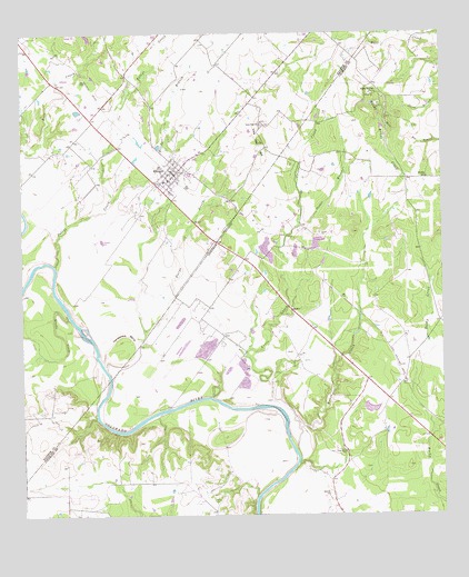
Ellinger, TX USGS Topographic Map
Click on map above to begin viewing in our Map Viewer.

This topographic map contains these locations and features:
Feature Name Type Latitude Longitude GNIS ID View Map
Adkins CemeteryCemeteryN29.7541°W96.6939°1329228View Map
Audelia Road Branch LibraryBuildingN29.7741°W96.7183°2015079View Map
Böttger CemeteryCemeteryN29.7555°W96.6594°1330981View Map
Brush CreekStreamN29.7666°W96.6691°1331403View Map
Brushy CreekStreamN29.8016°W96.7364°1331429View Map
Brushy SchoolSchoolN29.8375°W96.6294°1331456View Map
Casa View Branch LibraryBuildingN29.7827°W96.6725°2014985View Map
Crier CreekStreamN29.7725°W96.6683°1333669View Map
Dutys CreekStreamN29.7877°W96.7253°1334815View Map
EllingerPopulated PlaceN29.8394°W96.7053°1335318View Map
Ellinger Post OfficePost OfficeN29.8398°W96.7030°2731445View Map
Ellinger Volunteer Fire DepartmentBuildingN29.8397°W96.7062°2552672View Map
Fllinger BranchStreamN29.8313°W96.7233°1335965View Map
Forest Green Branch LibraryBuildingN29.8163°W96.7444°2014943View Map
Gilliam Memorial Public LibraryBuildingN29.8283°W96.6814°2014963View Map
Horseshoe BendBendN29.7972°W96.7191°1338119View Map
Live Oak ChurchChurchN29.8513°W96.6783°1340243View Map
Live Oak HillSummitN29.8472°W96.6780°1340254View Map
Pettys CreekStreamN29.8147°W96.7403°1375430View Map
Rocky HillSummitN29.8527°W96.6414°1345478View Map
Rocky Hill SchoolLocaleN29.8594°W96.6441°1345479View Map
Schindler LakeReservoirN29.7702°W96.6536°1862085View Map
Schindler Lake DamDamN29.7702°W96.6536°1862084View Map
Shaws Bend CemeteryCemeteryN29.7663°W96.6541°1346998View Map
Snyder BranchStreamN29.8255°W96.6672°1347341View Map

Note: Coordinates in the location and feature list above are referenced to NAD83 datum.


Copyright (C) 2008-2025 Ryan Niemi / Sunset Dynamics ... All Rights Reserved