TopoQuest Logo
Do you find TopoQuest useful?
Help keep TopoQuest running and adding new maps/features by donating!
Bitcoin:  19c7KJd3qBynnjoSw5npx9KScwjBe4ifkT
Litecoin:  LXs6TkuXGGXo1vDsWCkWVdjQX94eUKd6ui
Home View Maps Find Maps Find Places Resources & Links


La Madera, New Mexico Topographic Map

USGS Map Title: La Madera, NM
USGS Map MRC: 36106D1
DRG (GeoTIFF) Download: o36106d1.tif


Neighboring USGS Topographic Map Quads:


  Canon Plaza, NM  
36106E2
 

  Las Tablas, NM  
36106E1
 

  Petaca Peak, NM  
36105E8
 

  Valle Grande Peak, NM  
36106D2
 

  La Madera, NM  
36106D1
 

  Servilleta Plaza, NM  
36105D8
 

  El Rito, NM  
36106C2
 

  Ojo Caliente, NM  
36106C1
 

  Taos Junction, NM  
36105C8


Map MRC Location:

N37°
W107°
N37°
W106°
H8 H7 H6 H5 H4 H3 H2 H1
G8 G7 G6 G5 G4 G3 G2 G1
F8 F7 F6 F5 F4 F3 F2 F1
E8 E7 E6 E5 E4 E3 E2 E1
D8 D7 D6 D5 D4 D3 D2 D1
C8 C7 C6 C5 C4 C3 C2 C1
B8 B7 B6 B5 B4 B3 B2 B1
A8 A7 A6 A5 A4 A3 A2 A1
N36°
W107°
N36°
W106°

La Madera, NM USGS 1:24K Topographic Map Preview:
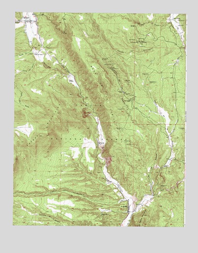
La Madera, NM USGS Topographic Map
Click on map above to begin viewing in our Map Viewer.

This topographic map contains these locations and features:
Feature Name Type Latitude Longitude GNIS ID View Map
Ajax MineMineN36.4834°W106.0345°903027View Map
Alamos DepositMineN36.4575°W106.0517°916749View Map
AltoMineN36.4639°W106.0520°916752View Map
Ancon MineMineN36.4234°W106.0434°903154View Map
AnconesPopulated PlaceN36.4239°W106.0631°903155View Map
Ancones Post Office (historical)Post OfficeN36.4239°W106.0631°937742View Map
Ancones TankReservoirN36.4001°W106.1125°913970View Map
Ancones Trick TankReservoirN36.4039°W106.1002°913969View Map
Big BugMineN36.4242°W106.0436°916743View Map
Big Bug MineMineN36.4253°W106.0450°903780View Map
Blanca MineMineN36.4847°W106.0386°903911View Map
Blue Eagle Number One MineMineN36.4928°W106.0381°903938View Map
Burma Trick TankReservoirN36.4962°W106.0891°913965View Map
Caņada de BorrachoStreamN36.4953°W106.1128°904397View Map
Caņada de OlguinStreamN36.4645°W106.0850°902882View Map
Caņada del AbrevaderoStreamN36.4800°W106.0009°904387View Map
Caņada del AguaStreamN36.4761°W106.1089°904390View Map
Caņada del los TanquesStreamN36.4964°W106.0103°904386View Map
Caņon de la MaderaValleyN36.3903°W106.0389°904546View Map
Caņon de la PalomaValleyN36.3964°W106.0167°904525View Map
Caņon de los AlamosValleyN36.3920°W106.0236°904528View Map
Dwight Baker DamDamN36.4817°W106.0339°924134View Map
El Capitan MineMineN36.4831°W106.0359°906040View Map
FreelandMineN36.4884°W106.0934°916773View Map
Gavilan MineMineN36.4942°W106.0364°906509View Map
Globe MineMineN36.4495°W106.0409°906566View Map
Guadalupe MineMineN36.4439°W106.0456°906763View Map
Hidden Treasure MineMineN36.4322°W106.0486°906963View Map
Jam MineMineN36.4572°W106.0720°916703View Map
La MaderaPopulated PlaceN36.3870°W106.0414°907731View Map
La MaderaPopulated PlaceN36.3864°W106.0410°2633185View Map
La Madera Census Designated PlaceCensusN36.3808°W106.0420°2584129View Map
La Madera FluorsparMineN36.4409°W106.0409°917336View Map
La Madera MineMineN36.3961°W106.0242°917337View Map
La Madera Post OfficePost OfficeN36.3836°W106.0403°938303View Map
LaPaloma MineMineN36.4642°W106.0292°907732View Map
Laura Crystal ProspectLocaleN36.4328°W106.0017°907897View Map
Little Julia MineMineN36.4700°W106.0556°908027View Map
Little Julia Number 1 MineMineN36.4734°W106.0584°908028View Map
Lower Abrevadero TankReservoirN36.4719°W106.0254°913967View Map
Lower Alamos ProspectMineN36.3959°W106.0239°916767View Map
Maria Theresa GroupMineN36.3947°W106.0153°916766View Map
MedozaMineN36.4809°W106.0300°916740View Map
Mesa de la JaritaSummitN36.4950°W106.0842°908604View Map
Nambe MineMineN36.4809°W106.0345°909014View Map
Ortega MountainsRangeN36.4328°W106.1025°920659View Map
Ortega TankReservoirN36.4111°W106.1012°913968View Map
Paloma Canyon ProspectLocaleN36.3992°W106.0178°909456View Map
Pavo MineMineN36.4834°W106.0322°909515View Map
PetacaCivilN36.4992°W106.0042°909583View Map
Pineapple Group MineMineN36.4600°W106.0267°909693View Map
Queen of Sheba MineMineN36.4484°W106.0414°909925View Map
Rainbow MineMineN36.4850°W106.0317°909965View Map
Rancho de OlguinLocaleN36.4606°W106.0856°909993View Map
Rancho deTrujilloLocaleN36.4759°W106.1106°909995View Map
Red MineMineN36.4522°W106.0386°910072View Map
Rio TusasStreamN36.3831°W106.0378°928795View Map
Rio VallecitosStreamN36.3831°W106.0375°910261View Map
Salt LickMineN36.4100°W106.0167°917012View Map
Salt Lick SpringSpringN36.4106°W106.0156°910575View Map
SnowstormMineN36.4775°W106.0356°916729View Map
South PetacaPopulated PlaceN36.4972°W106.0103°911265View Map
Statue SpringSpringN36.3819°W106.0604°911398View Map
Sunnyside MineMineN36.4542°W106.0497°911496View Map
Triple E MineMineN36.4531°W106.0453°911818View Map
Triple EEE-A MineMineN36.4581°W106.0089°939910View Map
Tusas River Canyon Magnetite MineMineN36.4581°W106.0089°916732View Map
Upper Abrevadero TankReservoirN36.4876°W106.0731°913966View Map
VallecitosPopulated PlaceN36.4950°W106.1167°912055View Map
Vallecitos Federal Sustained Yield UnitForestN36.4569°W106.1125°2677989View Map
Vallecitos Volunteer Fire DepartmentBuildingN36.4947°W106.1191°2657867View Map
Vallectos Deposit Number OneMineN36.4814°W106.1114°916734View Map
Vargas-JaramilloMineN36.4139°W106.0636°917279View Map
Verne Byrne Pit Number 406MineN36.4875°W106.0059°916718View Map
White MineMineN36.4606°W106.0447°912309View Map
White Mule MineMineN36.4742°W106.0309°939915View Map
Worm Mines Incorporated PropertyMineN36.4261°W106.0117°917275View Map

Note: Coordinates in the location and feature list above are referenced to NAD83 datum.


Copyright (C) 2008-2024 Ryan Niemi / Sunset Dynamics ... All Rights Reserved