TopoQuest Logo
Do you find TopoQuest useful?
Help keep TopoQuest running and adding new maps/features by donating!
Bitcoin:  19c7KJd3qBynnjoSw5npx9KScwjBe4ifkT
Litecoin:  LXs6TkuXGGXo1vDsWCkWVdjQX94eUKd6ui
Home View Maps Find Maps Find Places Resources & Links


Petaca Peak, New Mexico Topographic Map

USGS Map Title: Petaca Peak, NM
USGS Map MRC: 36105E8
DRG (GeoTIFF) Download: o36105e8.tif


Neighboring USGS Topographic Map Quads:


  Mule Canyon, NM  
36106F1
 

  Tres Piedras, NM  
36105F8
 

  Tres Piedras NE, NM  
36105F7
 

  Las Tablas, NM  
36106E1
 

  Petaca Peak, NM  
36105E8
 

  Cerro De Los Taoses, NM  
36105E7
 

  La Madera, NM  
36106D1
 

  Servilleta Plaza, NM  
36105D8
 

  Tres Orejas, NM  
36105D7


Map MRC Location:

N37°
W106°
N37°
W105°
H8 H7 H6 H5 H4 H3 H2 H1
G8 G7 G6 G5 G4 G3 G2 G1
F8 F7 F6 F5 F4 F3 F2 F1
E8 E7 E6 E5 E4 E3 E2 E1
D8 D7 D6 D5 D4 D3 D2 D1
C8 C7 C6 C5 C4 C3 C2 C1
B8 B7 B6 B5 B4 B3 B2 B1
A8 A7 A6 A5 A4 A3 A2 A1
N36°
W106°
N36°
W105°

Petaca Peak, NM USGS 1:24K Topographic Map Preview:
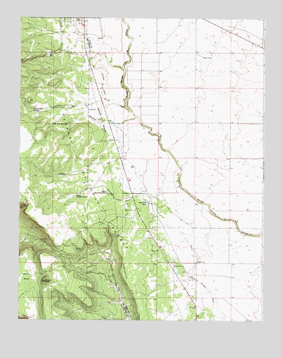
Petaca Peak, NM USGS Topographic Map
Click on map above to begin viewing in our Map Viewer.

This topographic map contains these locations and features:
Feature Name Type Latitude Longitude GNIS ID View Map
Ambrose TankReservoirN36.5738°W105.9493°913528View Map
Caņon de Tio GorditoValleyN36.5836°W105.9400°904558View Map
Cedar TankReservoirN36.5541°W105.9931°913527View Map
ChambersLocaleN36.5528°W105.9172°915068View Map
Comanche Number One TankReservoirN36.5029°W105.9646°913559View Map
Comanche Number Two TankReservoirN36.5263°W105.9658°913563View Map
L TankReservoirN36.5599°W105.9804°907601View Map
Malpais CanyonValleyN36.6042°W105.9481°937048View Map
Old Well TankReservoirN36.5811°W105.9831°909349View Map
Owl Trick TankReservoirN36.5322°W105.9425°913564View Map
Petaca MesaSummitN36.5159°W105.9947°909585View Map
Petaca PeakSummitN36.5159°W105.9864°909586View Map
Petaca Tank AReservoirN36.5229°W105.9920°913562View Map
Petaca Tank BReservoirN36.5006°W105.9933°913560View Map
Petaca Trick TankReservoirN36.5150°W105.9909°913561View Map
Rest Area Trick TankReservoirN36.5139°W105.9203°913570View Map
RG-29910 Water WellWellN36.5534°W105.9361°926872View Map
Rincon TankReservoirN36.5636°W105.9889°2678103View Map
Road Tank Number OneReservoirN36.6103°W105.9846°910339View Map
Road Tank Number TwoReservoirN36.6104°W105.9823°2678104View Map
Section Thirty One TankReservoirN36.5308°W105.9120°913526View Map
ServilletaPopulated PlaceN36.5534°W105.9356°901574View Map
Servilleta CanyonValleyN36.5353°W105.9153°910951View Map
Servilleta TankReservoirN36.5488°W105.9346°910953View Map
South Amador TankReservoirN36.5516°W105.9710°911214View Map
Tio Gordito TankReservoirN36.5863°W105.9908°911724View Map
Triangle TankReservoirN36.5090°W105.9095°913569View Map
West Servilleta TankReservoirN36.5529°W105.9556°912257View Map

Note: Coordinates in the location and feature list above are referenced to NAD83 datum.


Copyright (C) 2008-2025 Ryan Niemi / Sunset Dynamics ... All Rights Reserved