TopoQuest Logo
Do you find TopoQuest useful?
Help keep TopoQuest running and adding new maps/features by donating!
Bitcoin:  19c7KJd3qBynnjoSw5npx9KScwjBe4ifkT
Litecoin:  LXs6TkuXGGXo1vDsWCkWVdjQX94eUKd6ui
Home View Maps Find Maps Find Places Resources & Links


Lagan, Louisiana Topographic Map

USGS Map Title: Lagan, LA
USGS Map MRC: 29090H7
DRG (GeoTIFF) Download: o29090h7.tif


Neighboring USGS Topographic Map Quads:


  Donaldsonville, LA  
30090A8
 

  Convent, LA  
30090A7
 

  Lutcher, LA  
30090A6
 

  Madewood, LA  
29090H8
 

  Lagan, LA  
29090H7
 

  Lower Vacherie, LA  
29090H6
 

  Labadieville, LA  
29090G8
 

  Thibodaux, LA  
29090G7
 

  Kraemer, LA  
29090G6


Map MRC Location:

N30°
W91°
N30°
W90°
H8 H7 H6 H5 H4 H3 H2 H1
G8 G7 G6 G5 G4 G3 G2 G1
F8 F7 F6 F5 F4 F3 F2 F1
E8 E7 E6 E5 E4 E3 E2 E1
D8 D7 D6 D5 D4 D3 D2 D1
C8 C7 C6 C5 C4 C3 C2 C1
B8 B7 B6 B5 B4 B3 B2 B1
A8 A7 A6 A5 A4 A3 A2 A1
N29°
W91°
N29°
W90°

Lagan, LA USGS 1:24K Topographic Map Preview:
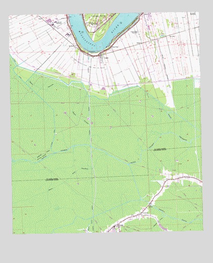
Lagan, LA USGS Topographic Map
Click on map above to begin viewing in our Map Viewer.

This topographic map contains these locations and features:
Feature Name Type Latitude Longitude GNIS ID View Map
BatreePopulated PlaceN29.9999°W90.7865°559832View Map
Batree Community Drainage CanalCanalN29.9663°W90.7726°559833View Map
Bay Tree Plantation (historical)LocaleN29.9835°W90.7793°1629159View Map
Bayou CitamonStreamN29.9316°W90.7712°559909View Map
Bayou Heron GraveyardCemeteryN29.9058°W90.7620°539993View Map
Bayou OnionStreamN29.8841°W90.8223°532708View Map
Bayou Petit ChackbayStreamN29.9194°W90.8109°560047View Map
Bayou PirogueStreamN29.9235°W90.8193°560055View Map
Bayou TraverseStreamN29.9580°W90.8351°560099View Map
Bayou VerretStreamN29.9166°W90.8634°560103View Map
Bessie KPopulated PlaceN29.9830°W90.7879°560157View Map
Bon Secours PlantationPopulated PlaceN29.9944°W90.8412°560244View Map
Cabanocey Plantation (historical)LocaleN29.9744°W90.8268°1629170View Map
CairePopulated PlaceN29.9980°W90.8534°560318View Map
Caribu LandingLocaleN29.9888°W90.8320°1628810View Map
ChackbayPopulated PlaceN29.8835°W90.7973°543077View Map
Chackbay Census Designated PlaceCensusN29.8981°W90.7622°2402758View Map
Chackbay Elementary SchoolSchoolN29.8786°W90.8086°557802View Map
Chackbay Volunteer Fire DepartmentBuildingN29.8801°W90.8060°2332446View Map
ChegbyPopulated PlaceN29.8785°W90.8073°1958527View Map
Chegby Gas FieldOilfieldN29.8860°W90.7618°557804View Map
Chopin (historical)Populated PlaceN29.9841°W90.8048°1629176View Map
College PointCapeN29.9963°W90.8162°560451View Map
College Point LandingLocaleN29.9946°W90.8259°1628809View Map
College Point LandingLocaleN29.9971°W90.8265°1629178View Map
Convent CourthouseBuildingN29.9943°W90.8173°2603319View Map
Cutgrass CouleeStreamN29.9230°W90.8484°560557View Map
Cutgrass Coulee Oil FieldOilfieldN29.9427°W90.8445°1629187View Map
Grand Bayou Mobile Home ParkPopulated PlaceN29.9080°W90.7771°2600410View Map
Home Place Plantation (historical)LocaleN29.9835°W90.8009°1629203View Map
Jefferson College (historical)SchoolN29.9944°W90.8204°1629205View Map
LaganPopulated PlaceN29.9755°W90.8145°1627423View Map
Laurel Ridge PlantationPopulated PlaceN29.9896°W90.7904°1627454View Map
Manresa House of RetreatsLocaleN29.9940°W90.8204°1627604View Map
Moonshine (historical)LocaleN29.9771°W90.8118°1629225View Map
Moonshine Census Designated PlaceCensusN29.9700°W90.8131°2583540View Map
North Vacherie Fire Department Saint James StationBuildingN29.9926°W90.8443°2332618View Map
Oak AlleyPopulated PlaceN29.9869°W90.7706°1627806View Map
Our Lady of Prompt Succor ChurchChurchN29.8795°W90.8061°2602550View Map
Parish Governing Authority District 5CivilN29.9885°W90.8619°1930097View Map
Pikes PeakPopulated PlaceN29.9805°W90.8081°1627920View Map
Rich BendBendN29.9835°W90.8190°1629238View Map
Rich Bend RevetmentLeveeN29.9808°W90.8265°1629239View Map
Saint Emma Plantation (historical)LocaleN29.9866°W90.8445°1629251View Map
Saint JamesPopulated PlaceN29.9819°W90.8318°1628114View Map
Saint James High SchoolSchoolN29.9888°W90.8364°1629774View Map
Saint James LandingLocaleN29.9810°W90.8270°1628811View Map
Saint James LandingLocaleN29.9819°W90.8273°1629253View Map
Saint James Parish Sheriff's OfficeBuildingN29.9940°W90.8174°2334160View Map
Saint James Parish Sheriff's Office - Juvenile DivisionBuildingN29.9940°W90.8175°2334175View Map
Saint James Parish Sheriff's Office - RecordsBuildingN29.9940°W90.8174°2333975View Map
Saint James PlantationPopulated PlaceN29.9983°W90.7518°1628121View Map
Saint James Post OfficePost OfficeN29.9825°W90.8309°2600358View Map
Saint James-College Point Gas and Oil FieldOilfieldN29.9710°W90.8218°1628122View Map
Saint Luke Baptist ChurchChurchN29.9775°W90.8152°2602692View Map
Saint Lukes ChurchChurchN29.8899°W90.7854°538956View Map
Saint Paul ChurchChurchN29.9983°W90.8373°1628148View Map
Union - Convent Fire Department Convent StationBuildingN29.9952°W90.8170°2332543View Map
Willow IslandIslandN29.9191°W90.8545°1628512View Map

Note: Coordinates in the location and feature list above are referenced to NAD83 datum.


Copyright (C) 2008-2024 Ryan Niemi / Sunset Dynamics ... All Rights Reserved