TopoQuest Logo
Do you find TopoQuest useful?
Help keep TopoQuest running and adding new maps/features by donating!
Bitcoin:  19c7KJd3qBynnjoSw5npx9KScwjBe4ifkT
Litecoin:  LXs6TkuXGGXo1vDsWCkWVdjQX94eUKd6ui
Home View Maps Find Maps Find Places Resources & Links


Laguna Vista, Texas Topographic Map

USGS Map Title: Laguna Vista, TX
USGS Map MRC: 26097A3
DRG (GeoTIFF) Download: o26097a3.tif


Neighboring USGS Topographic Map Quads:


  Laguna Atascosa, TX  
26097B4
 

  La Coma, TX  
26097B3
 

  Port Isabel NW, TX  
26097B2
 

  Los Fresnos, TX  
26097A4
 

  Laguna Vista, TX  
26097A3
 

  Port Isabel, TX  
26097A2
 

  East Brownsville, TX  
25097H4
 

  Palmito Hill, TX  
25097H3
 

  Mouth of Rio Grande, TX  
25097H2


Map MRC Location:

N27°
W98°
N27°
W97°
H8 H7 H6 H5 H4 H3 H2 H1
G8 G7 G6 G5 G4 G3 G2 G1
F8 F7 F6 F5 F4 F3 F2 F1
E8 E7 E6 E5 E4 E3 E2 E1
D8 D7 D6 D5 D4 D3 D2 D1
C8 C7 C6 C5 C4 C3 C2 C1
B8 B7 B6 B5 B4 B3 B2 B1
A8 A7 A6 A5 A4 A3 A2 A1
N26°
W98°
N26°
W97°

Laguna Vista, TX USGS 1:24K Topographic Map Preview:
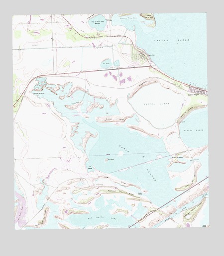
Laguna Vista, TX USGS Topographic Map
Click on map above to begin viewing in our Map Viewer.

This topographic map contains these locations and features:
Feature Name Type Latitude Longitude GNIS ID View Map
Bahia GrandeLakeN26.0409°W97.2958°1372369View Map
Bird IslandIslandN26.0401°W97.3158°1372585View Map
Brownsville Ship ChannelChannelN26.0067°W97.2744°1372751View Map
Cameron Company Fwsd Reservoir 1ReservoirN26.1202°W97.3200°1862185View Map
Cameron County Fwsd Dam 1DamN26.1220°W97.3136°1862184View Map
Carretas CrossingPopulated PlaceN26.0198°W97.2919°1380826View Map
City of Port Isabel ReservoirReservoirN26.1215°W97.3141°1373115View Map
El TularLakeN26.0961°W97.3150°1373611View Map
La AtravezadaSummitN26.0854°W97.2875°1374410View Map
La Aura CrossingPopulated PlaceN26.0259°W97.3230°1380869View Map
La EscaleBayN26.0365°W97.3266°1374414View Map
Laguna HeightsPopulated PlaceN26.0801°W97.2539°1374433View Map
Laguna Heights Census Designated PlaceCensusN26.0802°W97.2569°2408525View Map
Laguna LargaLakeN26.0718°W97.2822°1374434View Map
Laguna VistaPopulated PlaceN26.1009°W97.2903°1374437View Map
Laguna Vista CoveBayN26.1209°W97.2978°1374438View Map
Laguna Vista Police DepartmentBuildingN26.1024°W97.2914°2335105View Map
Laguna Vista Public LibraryBuildingN26.1037°W97.2914°2014905View Map
Laguna Vista Town HallBuildingN26.1025°W97.2914°2753749View Map
Laguna Vista Volunteer Fire DepartmentBuildingN26.0975°W97.2884°2334527View Map
Loma de la GrullaSummitN26.1237°W97.2880°1374652View Map
Loma del BalloSummitN26.0242°W97.2625°1374662View Map
Loma del Potrero CercadoSummitN26.0120°W97.2564°1374671View Map
Loma la CuchillaSummitN26.0698°W97.2594°1374673View Map
Loma la JaujaSummitN26.1248°W97.3222°1374674View Map
Long RidgeRidgeN26.0276°W97.3105°1374713View Map
Paso CorvinasChannelN26.0398°W97.2600°1375365View Map
Posta de RoqueGapN26.0412°W97.2700°1375543View Map
Puerta de TrancasGapN26.0087°W97.2883°1375577View Map
Punta de las BahiasCapeN26.0787°W97.3589°1375582View Map
Redhead RidgeRidgeN26.0217°W97.3069°1375687View Map
Rincon de las ViejasSummitN26.0040°W97.3580°1375744View Map
Rincon LargoSummitN26.0634°W97.3166°1375746View Map
Rutherford-Harding Addition ColoniaPopulated PlaceN26.0804°W97.2564°2010207View Map
San Martin LakeLakeN26.0079°W97.3210°1375973View Map
Town of Laguna VistaCivilN26.1075°W97.2968°2412859View Map
Vadia AnchaLakeN26.0578°W97.2560°1376558View Map

Note: Coordinates in the location and feature list above are referenced to NAD83 datum.


Copyright (C) 2008-2025 Ryan Niemi / Sunset Dynamics ... All Rights Reserved