TopoQuest Logo
Do you find TopoQuest useful?
Help keep TopoQuest running and adding new maps/features by donating!
Bitcoin:  19c7KJd3qBynnjoSw5npx9KScwjBe4ifkT
Litecoin:  LXs6TkuXGGXo1vDsWCkWVdjQX94eUKd6ui
Home View Maps Find Maps Find Places Resources & Links


Laguna Atascosa, Texas Topographic Map

USGS Map Title: Laguna Atascosa, TX
USGS Map MRC: 26097B4
DRG (GeoTIFF) Download: o26097b4.tif


Neighboring USGS Topographic Map Quads:


  Paso Real, TX  
26097C5
 

  La Leona, TX  
26097C4
 

  Three Islands, TX  
26097C3
 

  Rio Hondo, TX  
26097B5
 

  Laguna Atascosa, TX  
26097B4
 

  La Coma, TX  
26097B3
 

  Olmito, TX  
26097A5
 

  Los Fresnos, TX  
26097A4
 

  Laguna Vista, TX  
26097A3


Map MRC Location:

N27°
W98°
N27°
W97°
H8 H7 H6 H5 H4 H3 H2 H1
G8 G7 G6 G5 G4 G3 G2 G1
F8 F7 F6 F5 F4 F3 F2 F1
E8 E7 E6 E5 E4 E3 E2 E1
D8 D7 D6 D5 D4 D3 D2 D1
C8 C7 C6 C5 C4 C3 C2 C1
B8 B7 B6 B5 B4 B3 B2 B1
A8 A7 A6 A5 A4 A3 A2 A1
N26°
W98°
N26°
W97°

Laguna Atascosa, TX USGS 1:24K Topographic Map Preview:
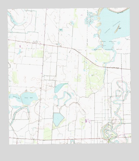
Laguna Atascosa, TX USGS Topographic Map
Click on map above to begin viewing in our Map Viewer.

This topographic map contains these locations and features:
Feature Name Type Latitude Longitude GNIS ID View Map
Alfredo Garza ColoniaPopulated PlaceN26.2234°W97.4883°2010311View Map
Arroyo GardensPopulated PlaceN26.2256°W97.4940°2413613View Map
Arroyo Gardens Number 2 ColoniaPopulated PlaceN26.2373°W97.4983°2010318View Map
Arroyo Gardens Number 4 ColoniaPopulated PlaceN26.2442°W97.4803°2010319View Map
Arroyo Gardens-La Tina Ranch Census Designated Place (historical)CensusN26.2195°W97.4860°2407768View Map
BayviewPopulated PlaceN26.1287°W97.3983°1330174View Map
Cain Dam 2DamN26.1720°W97.3753°1862190View Map
Cain Reservoir 2ReservoirN26.1766°W97.3792°1862191View Map
Cameron CountyCivilN26.1515°W97.4529°1383816View Map
Cross LakeReservoirN26.1677°W97.4845°1333715View Map
East Fresnos ColoniaPopulated PlaceN26.1342°W97.4703°2010347View Map
El Civolo TankReservoirN26.2307°W97.4457°1335178View Map
El Preseno LakeReservoirN26.2109°W97.4885°1335247View Map
Espuela TankReservoirN26.2176°W97.4489°1335518View Map
Esquina ColoniaPopulated PlaceN26.1284°W97.4692°2010252View Map
Gumesindo Galvan ColoniaPopulated PlaceN26.2165°W97.4764°2010262View Map
Hormigas LakeSwampN26.1885°W97.4162°1338085View Map
Juan Gonzales ColoniaPopulated PlaceN26.2134°W97.4703°2010271View Map
La TinaPopulated PlaceN26.2195°W97.4719°2034884View Map
La Tina RanchPopulated PlaceN26.2187°W97.4747°1339430View Map
La Tina Ranch Census Designated PlaceCensusN26.2031°W97.4764°2584673View Map
Laguna AtascosaLakeN26.2367°W97.3890°1339458View Map
Leonar B De Villarreal ColoniaPopulated PlaceN26.2104°W97.4783°2010286View Map
Los Fresnos Fire DepartmentBuildingN26.1266°W97.3996°2334464View Map
Lourdes Street ColoniaPopulated PlaceN26.1259°W97.4742°2010292View Map
Mercer Dry Reservoir LeveeDamN26.1487°W97.4553°1862192View Map
Mercer Reservoir 1SwampN26.1776°W97.4484°1862195View Map
Mercer Reservoir 1 LeveeDamN26.1737°W97.4519°1862194View Map
Mercer Reservoir 2ReservoirN26.1656°W97.4400°1862197View Map
Mercer Reservoir 2 DamDamN26.1620°W97.4436°1862196View Map
Needle IslandIslandN26.2312°W97.3880°1342397View Map
Resaca de los FresnosReservoirN26.1681°W97.4442°1375698View Map
Reservoir Number SevenReservoirN26.2409°W97.4947°1345090View Map
Soldiers CemeteryCemeteryN26.1256°W97.4478°1347358View Map
Sweeney Lake East LeveeDamN26.1670°W97.4703°1862198View Map
Sweeney Lake West DamDamN26.1720°W97.4986°1862200View Map
Town of BayviewCivilN26.1329°W97.3973°2411669View Map
Vareno TankReservoirN26.2364°W97.4347°1349197View Map
Vicente Sandoval ColoniaPopulated PlaceN26.2123°W97.4833°2010235View Map

Note: Coordinates in the location and feature list above are referenced to NAD83 datum.


Copyright (C) 2008-2025 Ryan Niemi / Sunset Dynamics ... All Rights Reserved