TopoQuest Logo
Do you find TopoQuest useful?
Help keep TopoQuest running and adding new maps/features by donating!
Bitcoin:  19c7KJd3qBynnjoSw5npx9KScwjBe4ifkT
Litecoin:  LXs6TkuXGGXo1vDsWCkWVdjQX94eUKd6ui
Home View Maps Find Maps Find Places Resources & Links


Lake Auburn West, Maine Topographic Map

USGS Map Title: Lake Auburn West, ME
USGS Map MRC: 44070B3
DRG (GeoTIFF) Download: o44070b3.tif


Neighboring USGS Topographic Map Quads:


  West Sumner, ME  
44070C4
 

  Buckfield, ME  
44070C3
 

  Turner Center, ME  
44070C2
 

  Oxford, ME  
44070B4
 

  Lake Auburn West, ME  
44070B3
 

  Lake Auburn East, ME  
44070B2
 

  Mechanic Falls, ME  
44070A4
 

  Minot, ME  
44070A3
 

  Lewiston, ME  
44070A2


Map MRC Location:

N45°
W71°
N45°
W70°
H8 H7 H6 H5 H4 H3 H2 H1
G8 G7 G6 G5 G4 G3 G2 G1
F8 F7 F6 F5 F4 F3 F2 F1
E8 E7 E6 E5 E4 E3 E2 E1
D8 D7 D6 D5 D4 D3 D2 D1
C8 C7 C6 C5 C4 C3 C2 C1
B8 B7 B6 B5 B4 B3 B2 B1
A8 A7 A6 A5 A4 A3 A2 A1
N44°
W71°
N44°
W70°

Lake Auburn West, ME USGS 1:24K Topographic Map Preview:
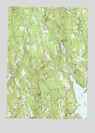
Lake Auburn West, ME USGS Topographic Map
Click on map above to begin viewing in our Map Viewer.

This topographic map contains these locations and features:
Feature Name Type Latitude Longitude GNIS ID View Map
Allen BrookStreamN44.2306°W70.3451°561177View Map
Androscoggin Learning and Transition CenterSchoolN44.1738°W70.2783°2738245View Map
Asa Bearce CemeteryCemeteryN44.1901°W70.3617°2724606View Map
Atkinson CemeteryCemeteryN44.1526°W70.3517°1908761View Map
Baker CemeteryCemeteryN44.1851°W70.3056°2736204View Map
Bicknell BrookStreamN44.2187°W70.3473°562118View Map
Black PondLakeN44.2309°W70.2622°562494View Map
Bog Brook CemeteryCemeteryN44.2035°W70.3495°2724618View Map
Bradbury HillSummitN44.1687°W70.3439°1908780View Map
Brighton HillSummitN44.2101°W70.3414°562972View Map
Brookvale CemeteryCemeteryN44.1487°W70.2870°1908782View Map
Brown CemeteryCemeteryN44.1339°W70.3742°2736208View Map
Center Hill CemeteryCemeteryN44.1326°W70.3159°563752View Map
Center MinotPopulated PlaceN44.1337°W70.3159°563760View Map
Chandler CemeteryCemeteryN44.1740°W70.3204°2736209View Map
Currier CemeteryCemeteryN44.1299°W70.3740°2736212View Map
Deane CemeteryCemeteryN44.1417°W70.3612°1908802View Map
Death ValleyBasinN44.1542°W70.3167°564929View Map
Dillingham CemeteryCemeteryN44.1793°W70.2710°2736214View Map
Dillingham HillSummitN44.1776°W70.2534°565102View Map
East HebronPopulated PlaceN44.2245°W70.3184°565619View Map
Freeman CemeteryCemeteryN44.1748°W70.3161°2736219View Map
Frog PondLakeN44.2309°W70.2634°566605View Map
Gauthier HillSummitN44.2129°W70.2856°561023View Map
Goff LedgeSummitN44.1516°W70.3258°566867View Map
Harlow CemeteryCemeteryN44.1836°W70.3279°1908845View Map
Hebron Fire Department Bruno StationBuildingN44.2240°W70.3621°2552778View Map
Hebron Pines CampgroundLocaleN44.2309°W70.3409°1908042View Map
Hebron StationLocaleN44.2273°W70.3467°567881View Map
Hebron Station SchoolSchoolN44.2300°W70.3502°2737950View Map
Hemond Airport (historical)AirportN44.1332°W70.3410°582187View Map
Hersey HillSummitN44.1874°W70.3177°567976View Map
Herseyville CemeteryCemeteryN44.1929°W70.2927°1908852View Map
Hilborn CemeteryCemeteryN44.1704°W70.3690°1908855View Map
Lily PondLakeN44.2418°W70.2669°569571View Map
Little Wilson PondLakeN44.2042°W70.2881°570107View Map
Lost Valley Ski AreaLocaleN44.1362°W70.2801°1908912View Map
Maheu Airport (historical)AirportN44.1398°W70.3481°582186View Map
Marstons HillSummitN44.1587°W70.2818°561020View Map
Minot Fire Department Orchard StationBuildingN44.1735°W70.3214°2552957View Map
Moody LibraryBuildingN44.2060°W70.3452°2738471View Map
Mount ProspectSummitN44.1476°W70.3569°573842View Map
Mud PondLakeN44.2407°W70.3145°571891View Map
Mud PondLakeN44.2199°W70.2980°571889View Map
Mud PondLakeN44.2264°W70.2609°571890View Map
North AuburnPopulated PlaceN44.1773°W70.2734°572243View Map
North Auburn CemeteryCemeteryN44.1860°W70.2716°572244View Map
North Auburn DamDamN44.1770°W70.2764°1773985View Map
Perkins RidgeRidgeN44.1376°W70.2934°561024View Map
Pine PointCapeN44.1409°W70.2626°573394View Map
Pottle HillSummitN44.1326°W70.3726°573732View Map
Riverside CemeteryCemeteryN44.1637°W70.3715°1908969View Map
Salmon PointCapeN44.1542°W70.2531°1908991View Map
Sandy Bottom PondLakeN44.2225°W70.2614°574869View Map
Scott Family GraveyardCemeteryN44.1750°W70.3164°1908993View Map
Shaw HillSummitN44.1267°W70.3132°575322View Map
Skillings CornerPopulated PlaceN44.1990°W70.2734°575521View Map
Snell HillSummitN44.2387°W70.2896°575674View Map
South HillSummitN44.2490°W70.3271°575852View Map
Tabor Farm CemeteryCemeteryN44.1612°W70.2514°2736113View Map
The BasinReservoirN44.1486°W70.2541°576752View Map
Times SquareLocaleN44.2495°W70.3698°1908223View Map
Town of MinotCivilN44.1483°W70.3379°582599View Map
West AuburnPopulated PlaceN44.1567°W70.2809°578018View Map
West MinotPopulated PlaceN44.1712°W70.3659°578173View Map
West Minot Village Fire DepartmentBuildingN44.1715°W70.3666°2553227View Map
West Turner CemeteryCemeteryN44.2208°W70.3182°2736119View Map
Whitman HillSummitN44.2467°W70.3666°578404View Map
Wilson Hill CemeteryCemeteryN44.2047°W70.2978°2729916View Map
Wood Street CemeteryCemeteryN44.1955°W70.2587°2729919View Map
Woodman CemeteryCemeteryN44.1291°W70.3412°1909049View Map
Woodman HillSummitN44.1258°W70.3349°578685View Map
Woodward MountainSummitN44.1826°W70.3196°1909050View Map
Youngs CornerPopulated PlaceN44.1273°W70.2712°578792View Map

Note: Coordinates in the location and feature list above are referenced to NAD83 datum.


Copyright (C) 2008-2024 Ryan Niemi / Sunset Dynamics ... All Rights Reserved