TopoQuest Logo
Do you find TopoQuest useful?
Help keep TopoQuest running and adding new maps/features by donating!
Bitcoin:  19c7KJd3qBynnjoSw5npx9KScwjBe4ifkT
Litecoin:  LXs6TkuXGGXo1vDsWCkWVdjQX94eUKd6ui
Home View Maps Find Maps Find Places Resources & Links


Oxford, Maine Topographic Map

USGS Map Title: Oxford, ME
USGS Map MRC: 44070B4
DRG (GeoTIFF) Download: o44070b4.tif


Neighboring USGS Topographic Map Quads:


  West Paris, ME  
44070C5
 

  West Sumner, ME  
44070C4
 

  Buckfield, ME  
44070C3
 

  Norway, ME  
44070B5
 

  Oxford, ME  
44070B4
 

  Lake Auburn West, ME  
44070B3
 

  Casco, ME  
44070A5
 

  Mechanic Falls, ME  
44070A4
 

  Minot, ME  
44070A3


Map MRC Location:

N45°
W71°
N45°
W70°
H8 H7 H6 H5 H4 H3 H2 H1
G8 G7 G6 G5 G4 G3 G2 G1
F8 F7 F6 F5 F4 F3 F2 F1
E8 E7 E6 E5 E4 E3 E2 E1
D8 D7 D6 D5 D4 D3 D2 D1
C8 C7 C6 C5 C4 C3 C2 C1
B8 B7 B6 B5 B4 B3 B2 B1
A8 A7 A6 A5 A4 A3 A2 A1
N44°
W71°
N44°
W70°

Oxford, ME USGS 1:24K Topographic Map Preview:
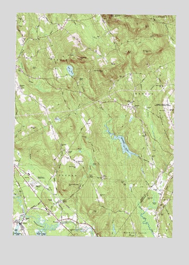
Oxford, ME USGS Topographic Map
Click on map above to begin viewing in our Map Viewer.

This topographic map contains these locations and features:
Feature Name Type Latitude Longitude GNIS ID View Map
Barnett PondLakeN44.1727°W70.4481°561627View Map
Ben Barrows HillSummitN44.2285°W70.3975°581392View Map
Brett HillSummitN44.2191°W70.4874°562934View Map
Brimstone CornerPopulated PlaceN44.2076°W70.4967°579154View Map
Bryant Record CemeteryCemeteryN44.2130°W70.4206°2724625View Map
Bucknam CemeteryCemeteryN44.1520°W70.3870°1908783View Map
Caldwell CornerPopulated PlaceN44.1720°W70.4584°579170View Map
Churchyard CemeteryCemeteryN44.2013°W70.4080°2724638View Map
Cobb BrookStreamN44.2387°W70.3784°564119View Map
Craigie CemeteryCemeteryN44.1380°W70.4718°2736852View Map
Cushman BrookStreamN44.2023°W70.3962°564697View Map
Dunham BrookStreamN44.1826°W70.4214°565404View Map
Durrell HillSummitN44.2243°W70.4701°565439View Map
Durrell Hill CemeteryCemeteryN44.2249°W70.4705°2736856View Map
Fairview CemeteryCemeteryN44.2077°W70.4960°566004View Map
First Congregational ChurchChurchN44.1342°W70.4912°1908013View Map
Freeland Holmes LibraryBuildingN44.1326°W70.4962°2738411View Map
Gardner BrookStreamN44.1390°W70.3964°566693View Map
Greenwood MountainSummitN44.2001°W70.3795°561025View Map
Greenwood Mountain CemeteryCemeteryN44.1969°W70.3791°561026View Map
Hall PondReservoirN44.2181°W70.4569°567511View Map
Hall Pond DamDamN44.2158°W70.4539°1774185View Map
Hawkes CemeteryCemeteryN44.1501°W70.3837°1908848View Map
Hawkes HillSummitN44.1462°W70.3972°561018View Map
Hawkes PondLakeN44.1456°W70.3896°1908849View Map
HebronPopulated PlaceN44.1981°W70.4064°567879View Map
Hebron AcademySchoolN44.1977°W70.4070°567880View Map
Hebron Community Baptist ChurchChurchN44.2012°W70.4084°1908039View Map
Hebron Elementary SchoolSchoolN44.1967°W70.4059°1908040View Map
Hebron Fire Department Station 1BuildingN44.1963°W70.4050°2552993View Map
Hebron Post OfficePost OfficeN44.1979°W70.4070°2768910View Map
Hebron Public LandsForestN44.2001°W70.3870°1908044View Map
Holmes CemeteryCemeteryN44.1690°W70.4565°1908051View Map
Hupper LibraryBuildingN44.2005°W70.4100°2738426View Map
Jam HillSummitN44.1390°W70.4342°568757View Map
Kimballs Airport (historical)AirportN44.1453°W70.4689°1908061View Map
King CemeteryCemeteryN44.2360°W70.4528°2736370View Map
Little Androscoggin River ReservoirReservoirN44.1325°W70.4620°1774212View Map
Little Singepole MountainSummitN44.2181°W70.4303°570060View Map
Maple Ridge CemeteryCemeteryN44.2103°W70.3845°570739View Map
Marshall PondReservoirN44.1774°W70.4153°581455View Map
Marshall Pond DamDamN44.1703°W70.4026°1774191View Map
Meadow BrookStreamN44.1334°W70.4553°571045View Map
Merrill Hill CemeteryCemeteryN44.1820°W70.3975°2724719View Map
Middle Branch Bog BrookStreamN44.1615°W70.3817°581460View Map
Minister BrookStreamN44.1295°W70.4478°571420View Map
Mount HungerSummitN44.1262°W70.4095°568454View Map
Mount MarieSummitN44.2220°W70.4214°570770View Map
Mud PondLakeN44.1906°W70.4650°564214View Map
Noble BrookStreamN44.2003°W70.4409°572210View Map
Number 4 HillSummitN44.2291°W70.4136°581588View Map
OxfordPopulated PlaceN44.1317°W70.4931°572899View Map
Oxford County Regional AirportAirportN44.1559°W70.4810°582202View Map
Oxford Elementary SchoolSchoolN44.1342°W70.4960°1908131View Map
Oxford Fire and Rescue Central StationBuildingN44.1458°W70.4786°2552772View Map
Oxford Plains SpeedwayParkN44.1542°W70.4842°1908136View Map
Oxford Police DepartmentBuildingN44.1337°W70.4961°2735869View Map
Oxford Post OfficePost OfficeN44.1322°W70.4950°1908137View Map
Oxford StationPopulated PlaceN44.1448°W70.4623°572900View Map
Paine CornerPopulated PlaceN44.1581°W70.4309°579597View Map
Pratt CornerPopulated PlaceN44.1584°W70.4403°579637View Map
Riverside CemeteryCemeteryN44.1334°W70.4898°1908157View Map
Robinson HillSummitN44.1476°W70.4339°574324View Map
Rock-O-Dundee HillSummitN44.1533°W70.4582°574353View Map
Rowe CemeteryCemeteryN44.1567°W70.4128°574542View Map
Russell CemeteryCemeteryN44.1760°W70.4634°574609View Map
Saint Marys Roman Catholic ChurchChurchN44.1326°W70.4917°1908178View Map
Sam Rowe HillSummitN44.1638°W70.4503°561028View Map
Shepardsfield CemeteryCemeteryN44.1667°W70.4503°565652View Map
Singepole MountainSummitN44.2254°W70.4502°575493View Map
Stone HillSummitN44.2435°W70.3997°576378View Map
Streaked MountainSummitN44.2499°W70.4234°576435View Map
Streaked Mountain CemeteryCemeteryN44.2474°W70.4322°2724802View Map
The Church of Jesus Christ of Latter Day SaintsChurchN44.1601°W70.4989°1907967View Map
Thomas HillSummitN44.1808°W70.4431°576987View Map
Thompson Lake DamDamN44.1315°W70.4947°1773547View Map
Town of HebronCivilN44.2107°W70.3818°582516View Map
Town of OxfordCivilN44.1443°W70.4762°582658View Map
Town of ParisCivilN44.2445°W70.4883°582661View Map
Twitchell BrookStreamN44.2226°W70.4976°577492View Map
Washburn CemeteryCemeteryN44.1284°W70.4559°1908236View Map
WelchvillePopulated PlaceN44.1337°W70.4639°577986View Map
Welchville DamDamN44.1325°W70.4620°1774211View Map
West Branch Bog BrookStreamN44.1490°W70.3892°578039View Map
Western Maine SanatoriumHospitalN44.1976°W70.3817°578261View Map
Whitman CemeteryCemeteryN44.1706°W70.3926°1908251View Map
Whitney HillSummitN44.1839°W70.4848°578416View Map
Willow BrookStreamN44.1540°W70.4712°578531View Map

Note: Coordinates in the location and feature list above are referenced to NAD83 datum.


Copyright (C) 2008-2024 Ryan Niemi / Sunset Dynamics ... All Rights Reserved