TopoQuest Logo
Do you find TopoQuest useful?
Help keep TopoQuest running and adding new maps/features by donating!
Bitcoin:  19c7KJd3qBynnjoSw5npx9KScwjBe4ifkT
Litecoin:  LXs6TkuXGGXo1vDsWCkWVdjQX94eUKd6ui
Home View Maps Find Maps Find Places Resources & Links


Lake Bonham, Texas Topographic Map

USGS Map Title: Lake Bonham, TX
USGS Map MRC: 33096F2
DRG (GeoTIFF) Download: o33096f2.tif


Neighboring USGS Topographic Map Quads:


  Kemp, OK  
33096G3
 

  Yuba, OK  
33096G2
 

  Telephone, TX  
33096G1
 

  Mulberry, TX  
33096F3
 

  Lake Bonham, TX  
33096F2
 

  Lamasco, TX  
33096F1
 

  Ector, TX  
33096E3
 

  Bonham, TX  
33096E2
 

  Dodd City, TX  
33096E1


Map MRC Location:

N34°
W97°
N34°
W96°
H8 H7 H6 H5 H4 H3 H2 H1
G8 G7 G6 G5 G4 G3 G2 G1
F8 F7 F6 F5 F4 F3 F2 F1
E8 E7 E6 E5 E4 E3 E2 E1
D8 D7 D6 D5 D4 D3 D2 D1
C8 C7 C6 C5 C4 C3 C2 C1
B8 B7 B6 B5 B4 B3 B2 B1
A8 A7 A6 A5 A4 A3 A2 A1
N33°
W97°
N33°
W96°

Lake Bonham, TX USGS 1:24K Topographic Map Preview:
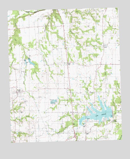
Lake Bonham, TX USGS Topographic Map
Click on map above to begin viewing in our Map Viewer.

This topographic map contains these locations and features:
Feature Name Type Latitude Longitude GNIS ID View Map
Anthony BranchStreamN33.7234°W96.2433°1381322View Map
BettisPopulated PlaceN33.7462°W96.1436°1381408View Map
Bettis CemeteryCemeteryN33.7468°W96.1539°1381409View Map
Bettis CreekStreamN33.7451°W96.1797°1381410View Map
BoydPopulated PlaceN33.6520°W96.1797°1381495View Map
Boyd LakeLakeN33.6406°W96.1780°1381497View Map
Brown Shed CemeteryCemeteryN33.6323°W96.1728°1381522View Map
City of RavennaCivilN33.6705°W96.2409°2411523View Map
Corrigan Lake Number 1ReservoirN33.7034°W96.2336°1855030View Map
Corrigan Lake Number 1 DamDamN33.7034°W96.2336°1855029View Map
Corrigan Lake Number 2ReservoirN33.7051°W96.2286°1855028View Map
Corrigan Lake Number 2 DamDamN33.7051°W96.2286°1855027View Map
East Oakland BranchStreamN33.6509°W96.1308°1381824View Map
Eminence CemeteryCemeteryN33.6454°W96.2455°1381843View Map
FinleyPopulated PlaceN33.7462°W96.1861°1381870View Map
IvanhoePopulated PlaceN33.7132°W96.1439°1382066View Map
Ivanhoe Post OfficePost OfficeN33.7144°W96.1427°2731368View Map
Lake BonhamReservoirN33.6509°W96.1517°1383356View Map
Lake Bonham DamDamN33.6518°W96.1303°1855025View Map
Lake Bonham ParkParkN33.6404°W96.1380°2029025View Map
Lake Bonham Recreation AreaLocaleN33.6443°W96.1361°1383357View Map
Little Timber CreekStreamN33.6445°W96.1697°1382185View Map
MacedoniaqchurchChurchN33.6970°W96.2491°1382217View Map
New Hope CemeteryCemeteryN33.7481°W96.1256°1383534View Map
OaklandPopulated PlaceN33.6709°W96.1553°1382414View Map
Odd Fellows CemeteryCemeteryN33.6637°W96.2341°1383355View Map
RavennaPopulated PlaceN33.6729°W96.2416°1388218View Map
Ravenna City HallBuildingN33.6731°W96.2426°2753317View Map
Ravenna Post OfficePost OfficeN33.6733°W96.2426°2731641View Map
Ravenna Volunteer Fire DepartmentBuildingN33.6733°W96.2430°2655390View Map
RidingsPopulated PlaceN33.6995°W96.1844°1382619View Map
Sand CreekStreamN33.6434°W96.1775°1382696View Map
Sandy CemeteryCemeteryN33.7070°W96.2280°1382707View Map
Sandy ChurchChurchN33.7198°W96.2180°1382708View Map
Sandy Creek Ranch AirportAirportN33.7118°W96.2244°2676553View Map
Sandy LakeReservoirN33.7003°W96.2312°1382723View Map
Stillhouse BranchStreamN33.6520°W96.1308°1382814View Map
Stillhouse HollowValleyN33.6620°W96.1254°1382815View Map
Union ChurchChurchN33.7051°W96.2500°1382893View Map
Upper Union CemeteryCemeteryN33.6915°W96.2328°1382900View Map
West Oakland BranchStreamN33.6490°W96.1466°1382938View Map
White CemeteryCemeteryN33.6257°W96.1548°1382946View Map
White ShedPopulated PlaceN33.6326°W96.1655°1382957View Map
Wolf CreekStreamN33.6482°W96.1528°1382987View Map

Note: Coordinates in the location and feature list above are referenced to NAD83 datum.


Copyright (C) 2008-2024 Ryan Niemi / Sunset Dynamics ... All Rights Reserved