TopoQuest Logo
Do you find TopoQuest useful?
Help keep TopoQuest running and adding new maps/features by donating!
Bitcoin:  19c7KJd3qBynnjoSw5npx9KScwjBe4ifkT
Litecoin:  LXs6TkuXGGXo1vDsWCkWVdjQX94eUKd6ui
Home View Maps Find Maps Find Places Resources & Links


Lake Buchanan, Texas Topographic Map

USGS Map Title: Lake Buchanan, TX
USGS Map MRC: 30098G4
DRG (GeoTIFF) Download: o30098g4.tif


Neighboring USGS Topographic Map Quads:


  Indian Hills, TX  
30098H5
 

  Tow, TX  
30098H4
 

  Naruna, TX  
30098H3
 

  Lone Grove, TX  
30098G5
 

  Lake Buchanan, TX  
30098G4
 

  Council Creek, TX  
30098G3
 

  Cap Mountain, TX  
30098F5
 

  Kingsland, TX  
30098F4
 

  Longhorn Cavern, TX  
30098F3


Map MRC Location:

N31°
W99°
N31°
W98°
H8 H7 H6 H5 H4 H3 H2 H1
G8 G7 G6 G5 G4 G3 G2 G1
F8 F7 F6 F5 F4 F3 F2 F1
E8 E7 E6 E5 E4 E3 E2 E1
D8 D7 D6 D5 D4 D3 D2 D1
C8 C7 C6 C5 C4 C3 C2 C1
B8 B7 B6 B5 B4 B3 B2 B1
A8 A7 A6 A5 A4 A3 A2 A1
N30°
W99°
N30°
W98°

Lake Buchanan, TX USGS 1:24K Topographic Map Preview:
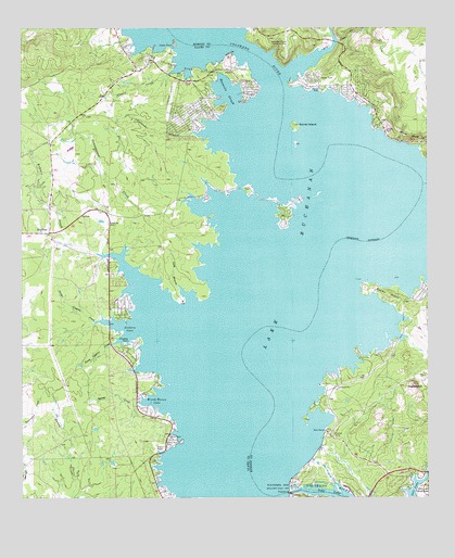
Lake Buchanan, TX USGS Topographic Map
Click on map above to begin viewing in our Map Viewer.

This topographic map contains these locations and features:
Feature Name Type Latitude Longitude GNIS ID View Map
Aero-Bee Ranch Airstrip (historical)AirportN30.8674°W98.4186°1386323View Map
Alexander BranchStreamN30.8468°W98.4473°1350970View Map
Beaver CreekStreamN30.8630°W98.4175°1351725View Map
Black RockCliffN30.7632°W98.4575°1352351View Map
Black Rock ParkParkN30.7649°W98.4542°1352352View Map
BlufftonPopulated PlaceN30.8207°W98.4914°1379435View Map
Bluffton Post OfficePost OfficeN30.8216°W98.4918°2731823View Map
Buchanan DamDamN30.7528°W98.4182°1353113View Map
Buchanan Dam Census Designated PlaceCensusN30.7807°W98.4392°2407917View Map
Buchanan Fire DepartmentBuildingN30.7543°W98.4600°2552109View Map
Buchanan Lake VillagePopulated PlaceN30.8507°W98.4495°2034951View Map
Buchanan Lake Village Census Designated PlaceCensusN30.8566°W98.4378°2586913View Map
Burnet County ParkParkN30.8463°W98.3842°2028695View Map
Campground CreekStreamN30.8288°W98.4481°1353709View Map
Cassie Volunteer Fire DepartmentBuildingN30.7832°W98.3931°2551370View Map
Cedar PointCapeN30.8710°W98.4523°1354142View Map
Cedar Point Recreation Area TrailTrailN30.8666°W98.4592°2032864View Map
Cowan CreekStreamN30.8632°W98.4528°1355220View Map
East Lake Buchanan Fire DepartmentBuildingN30.8595°W98.3994°2552075View Map
Garret IslandIslandN30.8488°W98.4153°1357900View Map
Golden BeachPopulated PlaceN30.8010°W98.4714°2034950View Map
Jeckers CoveBayN30.7957°W98.4678°1360191View Map
Lake BuchananReservoirN30.8183°W98.4227°1377210View Map
Llano County ParkParkN30.7666°W98.4545°2028961View Map
Long BranchStreamN30.8068°W98.4517°1361691View Map
Lower Colorado River Authority ParkParkN30.8635°W98.4461°1361907View Map
Maxwells SloughBayN30.8580°W98.4356°1362314View Map
NegroheadSummitN30.7802°W98.3792°1363662View Map
North Coggins CreekStreamN30.7971°W98.4770°1364020View Map
Redrock CreekStreamN30.8152°W98.4773°1366287View Map
Rocky PointCliffN30.8041°W98.3875°1366803View Map
Silver CreekStreamN30.8713°W98.4023°1368277View Map
Silver Creek VillagePopulated PlaceN30.8555°W98.3950°2034949View Map
South Coggins CreekStreamN30.7913°W98.4723°1368660View Map
Spring CreekStreamN30.7755°W98.4650°1368964View Map
White BluffCliffN30.8455°W98.3806°1371351View Map
Wirth Haven CoveBayN30.7771°W98.4589°1371818View Map

Note: Coordinates in the location and feature list above are referenced to NAD83 datum.


Copyright (C) 2008-2025 Ryan Niemi / Sunset Dynamics ... All Rights Reserved