TopoQuest Logo
Do you find TopoQuest useful?
Help keep TopoQuest running and adding new maps/features by donating!
Bitcoin:  19c7KJd3qBynnjoSw5npx9KScwjBe4ifkT
Litecoin:  LXs6TkuXGGXo1vDsWCkWVdjQX94eUKd6ui
Home View Maps Find Maps Find Places Resources & Links


Longhorn Cavern, Texas Topographic Map

USGS Map Title: Longhorn Cavern, TX
USGS Map MRC: 30098F3
DRG (GeoTIFF) Download: o30098f3.tif


Neighboring USGS Topographic Map Quads:


  Lake Buchanan, TX  
30098G4
 

  Council Creek, TX  
30098G3
 

  Burnet, TX  
30098G2
 

  Kingsland, TX  
30098F4
 

  Longhorn Cavern, TX  
30098F3
 

  Mormon Mill, TX  
30098F2
 

  Dunman Mountain, TX  
30098E4
 

  Marble Falls, TX  
30098E3
 

  Smithwick, TX  
30098E2


Map MRC Location:

N31°
W99°
N31°
W98°
H8 H7 H6 H5 H4 H3 H2 H1
G8 G7 G6 G5 G4 G3 G2 G1
F8 F7 F6 F5 F4 F3 F2 F1
E8 E7 E6 E5 E4 E3 E2 E1
D8 D7 D6 D5 D4 D3 D2 D1
C8 C7 C6 C5 C4 C3 C2 C1
B8 B7 B6 B5 B4 B3 B2 B1
A8 A7 A6 A5 A4 A3 A2 A1
N30°
W99°
N30°
W98°

Longhorn Cavern, TX USGS 1:24K Topographic Map Preview:
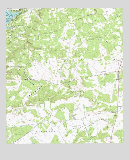
Longhorn Cavern, TX USGS Topographic Map
Click on map above to begin viewing in our Map Viewer.

This topographic map contains these locations and features:
Feature Name Type Latitude Longitude GNIS ID View Map
Austin and Northwestern Railroad Historic DistrictLocaleN30.6496°W98.2920°2032004View Map
Backbone RidgeRidgeN30.6849°W98.3272°1372364View Map
Backbone ValleyBasinN30.6371°W98.3172°1351389View Map
DemarcoLocaleN30.6935°W98.2542°1379650View Map
FairlandPopulated PlaceN30.6441°W98.2847°1379745View Map
Fairland CemeteryCemeteryN30.6419°W98.2839°2769988View Map
Hylton BranchStreamN30.7327°W98.3675°1359874View Map
Inks Lake State ParkParkN30.7310°W98.3706°1360013View Map
Inks Lake State Park TrailTrailN30.7368°W98.3706°2033465View Map
KHLB-FM (Burnet)TowerN30.7368°W98.2936°1385797View Map
Lakeland Hills Memorial ParkCemeteryN30.6782°W98.3179°2766139View Map
Long BranchStreamN30.6841°W98.2553°1361690View Map
Longhorn Cavern State ParkParkN30.6841°W98.3553°1374714View Map
Longhorn Cavern State Park TrailTrailN30.6832°W98.3520°2033408View Map
Mud Spring CreekStreamN30.6710°W98.2972°1363419View Map
Sam Bass ArchArchN30.6844°W98.3503°2678381View Map
ScobeePopulated PlaceN30.6457°W98.3161°1380505View Map
Spring CreekStreamN30.7480°W98.3586°1368971View Map
SudduthPopulated PlaceN30.6582°W98.2528°1380622View Map
Swamp CreekStreamN30.7132°W98.3450°1369442View Map
Tobey CemeteryCemeteryN30.6438°W98.3258°1369981View Map

Note: Coordinates in the location and feature list above are referenced to NAD83 datum.


Copyright (C) 2008-2025 Ryan Niemi / Sunset Dynamics ... All Rights Reserved