TopoQuest Logo
Do you find TopoQuest useful?
Help keep TopoQuest running and adding new maps/features by donating!
Bitcoin:  19c7KJd3qBynnjoSw5npx9KScwjBe4ifkT
Litecoin:  LXs6TkuXGGXo1vDsWCkWVdjQX94eUKd6ui
Home View Maps Find Maps Find Places Resources & Links


Barneston, Nebraska Topographic Map

USGS Map Title: Barneston, NE
USGS Map MRC: 40096A5
DRG (GeoTIFF) Download: o40096a5.tif


Neighboring USGS Topographic Map Quads:


  Blue Springs, NE  
40096B6
 

  Wymore NE, NE  
40096B5
 

  Lewiston, NE  
40096B4
 

  Wymore, NE  
40096A6
 

  Barneston, NE  
40096A5
 

  Liberty, NE  
40096A4
 

  Herkimer, KS  
39096H6
 

  Oketo, KS  
39096H5
 

  Axtell NW, KS  
39096H4


Map MRC Location:

N41°
W97°
N41°
W96°
H8 H7 H6 H5 H4 H3 H2 H1
G8 G7 G6 G5 G4 G3 G2 G1
F8 F7 F6 F5 F4 F3 F2 F1
E8 E7 E6 E5 E4 E3 E2 E1
D8 D7 D6 D5 D4 D3 D2 D1
C8 C7 C6 C5 C4 C3 C2 C1
B8 B7 B6 B5 B4 B3 B2 B1
A8 A7 A6 A5 A4 A3 A2 A1
N40°
W97°
N40°
W96°

Barneston, NE USGS 1:24K Topographic Map Preview:
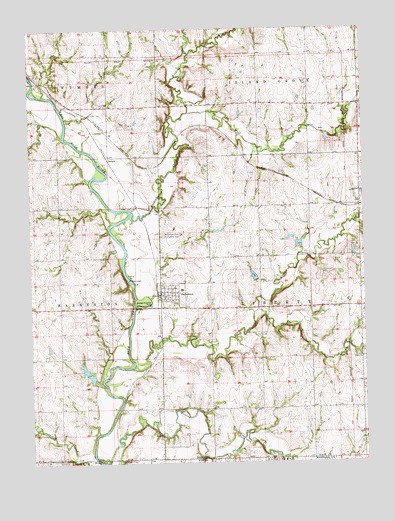
Barneston, NE USGS Topographic Map
Click on map above to begin viewing in our Map Viewer.

This topographic map contains these locations and features:
Feature Name Type Latitude Longitude GNIS ID View Map
Arkeketa CreekStreamN40.0439°W96.5406°827049View Map
BadgerPopulated PlaceN40.0883°W96.5956°835241View Map
BadgerLocaleN40.0883°W96.5956°1883147View Map
BarnestonPopulated PlaceN40.0483°W96.5770°827191View Map
BarnestonLocaleN40.0483°W96.5781°1883385View Map
Barneston CemeteryCemeteryN40.0661°W96.5758°827192View Map
Barneston Post OfficePost OfficeN40.0483°W96.5770°1883383View Map
Barneston Power Plant DamDamN40.0533°W96.5886°1768729View Map
Barneston Power Plant ReservoirReservoirN40.0533°W96.5886°1768730View Map
Barneston Rural Volunteer Fire DepartmentBuildingN40.0486°W96.5765°1883381View Map
Barneston School (historical)SchoolN40.0497°W96.5686°1883386View Map
Farmers Co-operative ElevatorLocaleN40.0483°W96.5770°1883382View Map
Mission CreekStreamN40.0006°W96.5970°472689View Map
Oto and Missouri Agency Historical MarkerParkN40.0458°W96.5767°1883390View Map
Plum Creek Dam 2-2DamN40.0695°W96.5245°1767687View Map
Plum Creek Dam 2-ADamN40.0663°W96.5010°1768691View Map
Plum Creek Dam 2-DDamN40.0617°W96.5248°1768655View Map
Plum Creek Dam 2-EDamN40.0524°W96.5409°1768657View Map
Plum Creek Dam 2-FDamN40.0622°W96.5044°1768601View Map
Plum Creek Reservoir 2-2ReservoirN40.0699°W96.5253°1767688View Map
Plum Creek Reservoir 2-DReservoirN40.0627°W96.5246°1768656View Map
Plum Creek Reservoir 2-EReservoirN40.0535°W96.5415°1768658View Map
Plum Creek Reservoir 2-FReservoirN40.0608°W96.5045°1768602View Map
Saint Joseph Catholic ChurchChurchN40.0483°W96.5770°1883384View Map
Saint Josephs CemeteryCemeteryN40.0653°W96.5761°832951View Map
Township of LibertyCivilN40.0447°W96.5202°838087View Map
Village of BarnestonCivilN40.0487°W96.5736°2398033View Map
Warford DamDamN40.0238°W96.6020°1768699View Map
Warford ReservoirReservoirN40.0252°W96.6034°1768700View Map
Wildcat CreekStreamN40.0725°W96.5875°834728View Map
Wolf CreekStreamN40.1008°W96.5656°834845View Map

Note: Coordinates in the location and feature list above are referenced to NAD83 datum.


Copyright (C) 2008-2025 Ryan Niemi / Sunset Dynamics ... All Rights Reserved