TopoQuest Logo
Do you find TopoQuest useful?
Help keep TopoQuest running and adding new maps/features by donating!
Bitcoin:  19c7KJd3qBynnjoSw5npx9KScwjBe4ifkT
Litecoin:  LXs6TkuXGGXo1vDsWCkWVdjQX94eUKd6ui
Home View Maps Find Maps Find Places Resources & Links


Lake Colorado City, Texas Topographic Map

USGS Map Title: Lake Colorado City, TX
USGS Map MRC: 32100C8
DRG (GeoTIFF) Download: o32100c8.tif


Neighboring USGS Topographic Map Quads:


  Cuthbert, TX  
32101D1
 

  Cedar Bend, TX  
32100D8
 

  Colorado City, TX  
32100D7
 

  Westbrook, TX  
32101C1
 

  Lake Colorado City, TX  
32100C8
 

  Colorado City SE, TX  
32100C7
 

  Hyman NE, TX  
32101B1
 

  Spade Ranch, TX  
32100B8
 

  Pecan Crossing, TX  
32100B7


Map MRC Location:

N33°
W101°
N33°
W100°
H8 H7 H6 H5 H4 H3 H2 H1
G8 G7 G6 G5 G4 G3 G2 G1
F8 F7 F6 F5 F4 F3 F2 F1
E8 E7 E6 E5 E4 E3 E2 E1
D8 D7 D6 D5 D4 D3 D2 D1
C8 C7 C6 C5 C4 C3 C2 C1
B8 B7 B6 B5 B4 B3 B2 B1
A8 A7 A6 A5 A4 A3 A2 A1
N32°
W101°
N32°
W100°

Lake Colorado City, TX USGS 1:24K Topographic Map Preview:
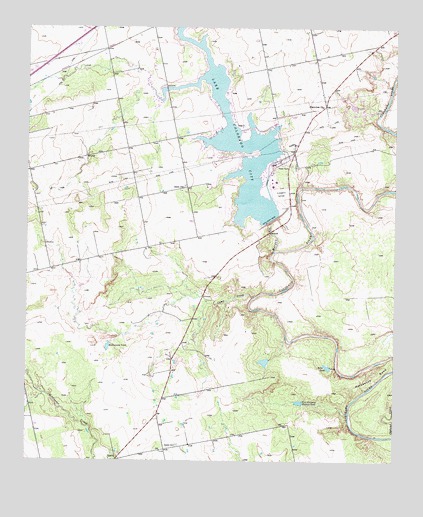
Lake Colorado City, TX USGS Topographic Map
Click on map above to begin viewing in our Map Viewer.

This topographic map contains these locations and features:
Feature Name Type Latitude Longitude GNIS ID View Map
Camp CreekStreamN32.2976°W100.9229°1331962View Map
Dorn ChurchChurchN32.3290°W100.9473°1334500View Map
Dorn SchoolSchoolN32.3451°W100.9384°1334501View Map
Five Hundred Pasture TankReservoirN32.2671°W100.9076°1335852View Map
Jayhawk CreekStreamN32.2590°W100.8754°1338681View Map
Lake Colorado CityReservoirN32.3437°W100.9301°1373165View Map
Lake Colorado City Census Designated PlaceCensusN32.3492°W100.9376°2586945View Map
Lake Colorado City DamDamN32.3185°W100.9171°1857577View Map
Lake Colorado City State ParkParkN32.3271°W100.9404°2029029View Map
Lake Colorado City State Park TrailTrailN32.3298°W100.9298°2033488View Map
Mitchell CountyCivilN32.3062°W100.9212°1383953View Map
Morgan CreekStreamN32.3107°W100.9165°1341910View Map
Plainview ChurchChurchN32.3529°W100.9001°1344161View Map
Rattlesnake TankReservoirN32.2836°W100.9724°1344830View Map
River Ranch TankReservoirN32.2789°W100.9190°1857576View Map
River Ranch Tank DamDamN32.2801°W100.9187°1857575View Map
River TankReservoirN32.2774°W100.8975°1345266View Map
SpadePopulated PlaceN32.2504°W100.9693°1379096View Map
Spade CemeteryCemeteryN32.2548°W100.9487°1347618View Map

Note: Coordinates in the location and feature list above are referenced to NAD83 datum.


Copyright (C) 2008-2025 Ryan Niemi / Sunset Dynamics ... All Rights Reserved