TopoQuest Logo
Do you find TopoQuest useful?
Help keep TopoQuest running and adding new maps/features by donating!
Bitcoin:  19c7KJd3qBynnjoSw5npx9KScwjBe4ifkT
Litecoin:  LXs6TkuXGGXo1vDsWCkWVdjQX94eUKd6ui
Home View Maps Find Maps Find Places Resources & Links


Afton, Wyoming Topographic Map

USGS Map Title: Afton, WY
USGS Map MRC: 42110F8
DRG (GeoTIFF) Download: o42110f8.tif


Neighboring USGS Topographic Map Quads:


  Auburn, WY  
42111G1
 

  Grover, WY  
42110G8
 

  Rock Lake Peak, WY  
42110G7
 

  Sage Valley, ID  
42111F1
 

  Afton, WY  
42110F8
 

  Red Top Mountain, WY  
42110F7
 

  Elk Valley, ID  
42111E1
 

  Smoot, WY  
42110E8
 

  Mount Wagner, WY  
42110E7


Map MRC Location:

N43°
W111°
N43°
W110°
H8 H7 H6 H5 H4 H3 H2 H1
G8 G7 G6 G5 G4 G3 G2 G1
F8 F7 F6 F5 F4 F3 F2 F1
E8 E7 E6 E5 E4 E3 E2 E1
D8 D7 D6 D5 D4 D3 D2 D1
C8 C7 C6 C5 C4 C3 C2 C1
B8 B7 B6 B5 B4 B3 B2 B1
A8 A7 A6 A5 A4 A3 A2 A1
N42°
W111°
N42°
W110°

Afton, WY USGS 1:24K Topographic Map Preview:
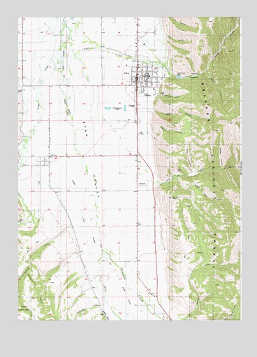
Afton, WY USGS Topographic Map
Click on map above to begin viewing in our Map Viewer.

This topographic map contains these locations and features:
Feature Name Type Latitude Longitude GNIS ID View Map
AftonPopulated PlaceN42.7249°W110.9319°1597691View Map
Afton CemeteryCemeteryN42.7180°W110.9233°1597692View Map
Afton Electric DamDamN42.7249°W110.9124°1607998View Map
Afton Electric ReservoirReservoirN42.7249°W110.9124°1607999View Map
Afton Elementary SchoolSchoolN42.7255°W110.9290°1795561View Map
Afton Municipal AirportAirportN42.7092°W110.9407°1608958View Map
Afton Post OfficePost OfficeN42.7257°W110.9343°2767902View Map
Afton Rest AreaLocaleN42.7299°W110.9391°1608759View Map
Afton Volunteer Fire DepartmentBuildingN42.7300°W110.9328°2673668View Map
Anderson CreekStreamN42.6322°W110.9494°1597750View Map
Bridger - Teton National Forest Greys River Ranger District Fire Engine CrewBuildingN42.7453°W110.9313°2673607View Map
Broad HollowValleyN42.6872°W110.8855°1598379View Map
Child CreekStreamN42.7030°W110.9935°1598731View Map
Cottonwood CreekStreamN42.6535°W110.9519°1598932View Map
Crow CreekStreamN42.7463°W110.9724°1599046View Map
Dry CreekStreamN42.6852°W110.9569°1599332View Map
Elbow CanyonValleyN42.7022°W110.9241°1599555View Map
FairviewPopulated PlaceN42.6885°W110.9824°1599653View Map
Fairview CanalCanalN42.6766°W110.9658°1599654View Map
Fairview CemeteryCemeteryN42.6818°W110.9883°1599655View Map
Fairview Census Designated PlaceCensusN42.6871°W110.9866°2408105View Map
Fairview Post OfficePost OfficeN42.6891°W110.9871°2767828View Map
Graveyard CanyonValleyN42.7191°W110.9210°1600057View Map
Greys River District Ranger OfficeLocaleN42.7308°W110.9327°1604782View Map
Hale CanyonValleyN42.7124°W110.9233°1600165View Map
Harmony CreekStreamN42.7316°W110.9974°1600217View Map
KRSV-AM (Afton)TowerN42.7227°W110.9616°1608789View Map
Landmark Star TowerTowerN42.7308°W110.9119°1604779View Map
Lincoln County Fair GroundsLocaleN42.7177°W110.9296°1600922View Map
Mikes Hole CreekStreamN42.6847°W110.9108°1601436View Map
OsmondPopulated PlaceN42.6830°W110.9321°1601950View Map
Osmond Census Designated PlaceCensusN42.6779°W110.9406°2585083View Map
Osmond SchoolSchoolN42.7249°W110.9319°1795562View Map
Red HollowValleyN42.7424°W110.9174°1602455View Map
Richardson CreekStreamN42.7108°W110.9944°389347View Map
Scout CanyonValleyN42.7277°W110.8949°1602785View Map
Sprague CreekStreamN42.6638°W110.9691°1603228View Map
Star Valley Elementary SchoolSchoolN42.7255°W110.9274°1603338View Map
Star Valley High SchoolSchoolN42.7249°W110.9319°1795559View Map
Star Valley High SchoolSchoolN42.7258°W110.9255°1603339View Map
Star Valley Junior High SchoolSchoolN42.7249°W110.9319°1795560View Map
Star Valley Junior High SchoolSchoolN42.7247°W110.9258°1603340View Map
Star Valley Latter Day Saints Hospital (historical)HospitalN42.7258°W110.9285°1603341View Map
Star Valley Medical CenterHospitalN42.7172°W110.9306°2673171View Map
Star Valley Medical Center Emergency Medical ServicesBuildingN42.7177°W110.9308°2673693View Map
Swift CreekStreamN42.7394°W110.9719°1604502View Map
Swift Creek Area MineMineN42.7333°W110.9274°1726514View Map
Swift Creek CampgroundLocaleN42.7249°W110.9027°1603491View Map
Swift Creek LakeReservoirN42.7251°W110.9101°1603493View Map
Town of AftonCivilN42.7295°W110.9317°2412337View Map
Twin HollowValleyN42.6844°W110.9024°1603829View Map
Wickiup KnollSummitN42.6752°W110.9127°1596346View Map
Y CanyonValleyN42.7374°W110.8860°1604303View Map

Note: Coordinates in the location and feature list above are referenced to NAD83 datum.


Copyright (C) 2008-2025 Ryan Niemi / Sunset Dynamics ... All Rights Reserved