TopoQuest Logo
Do you find TopoQuest useful?
Help keep TopoQuest running and adding new maps/features by donating!
Bitcoin:  19c7KJd3qBynnjoSw5npx9KScwjBe4ifkT
Litecoin:  LXs6TkuXGGXo1vDsWCkWVdjQX94eUKd6ui
Home View Maps Find Maps Find Places Resources & Links


Lake De Smet West, Wyoming Topographic Map

USGS Map Title: Lake De Smet West, WY
USGS Map MRC: 44106D7
DRG (GeoTIFF) Download: o44106d7.tif


Neighboring USGS Topographic Map Quads:


  Story, WY  
44106E8
 

  Banner, WY  
44106E7
 

  Horse Hill, WY  
44106E6
 

  Stone Mountain, WY  
44106D8
 

  Lake De Smet West, WY  
44106D7
 

  Lake De Smet East, WY  
44106D6
 

  Hunter Mesa, WY  
44106C8
 

  North Ridge, WY  
44106C7
 

  Buffalo, WY  
44106C6


Map MRC Location:

N45°
W107°
N45°
W106°
H8 H7 H6 H5 H4 H3 H2 H1
G8 G7 G6 G5 G4 G3 G2 G1
F8 F7 F6 F5 F4 F3 F2 F1
E8 E7 E6 E5 E4 E3 E2 E1
D8 D7 D6 D5 D4 D3 D2 D1
C8 C7 C6 C5 C4 C3 C2 C1
B8 B7 B6 B5 B4 B3 B2 B1
A8 A7 A6 A5 A4 A3 A2 A1
N44°
W107°
N44°
W106°

Lake De Smet West, WY USGS 1:24K Topographic Map Preview:
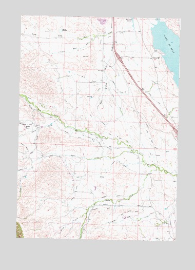
Lake De Smet West, WY USGS Topographic Map
Click on map above to begin viewing in our Map Viewer.

This topographic map contains these locations and features:
Feature Name Type Latitude Longitude GNIS ID View Map
Barkey DitchCanalN44.4603°W106.7992°1585126View Map
Brown and Foster DitchCanalN44.3850°W106.8014°1598392View Map
Father DeSmet Historical MonumentParkN44.4778°W106.7714°1588395View Map
Fish LateralCanalN44.4436°W106.8151°1588510View Map
Fox DitchCanalN44.4322°W106.8217°1588707View Map
H A CreekStreamN44.4678°W106.8078°1589209View Map
Hallie DitchCanalN44.4486°W106.8381°1589261View Map
Hopkins DitchCanalN44.3764°W106.7617°1604334View Map
Johnson CreekStreamN44.4164°W106.7664°1600640View Map
Johnson Creek DitchCanalN44.3939°W106.7964°1590158View Map
Kempton DitchCanalN44.4466°W106.8617°1590320View Map
Lake De SmetLakeN44.4786°W106.7521°1587390View Map
Lake DeSmet CanalCanalN44.4297°W106.7570°1590471View Map
Lily DitchCanalN44.4308°W106.8137°1590683View Map
Little North ForkStreamN44.4889°W106.8159°1590836View Map
McDonald CreekStreamN44.4377°W106.8578°1601301View Map
McGrath DitchCanalN44.3922°W106.8078°1591403View Map
Mowry BasinBasinN44.4372°W106.8681°1601595View Map
Mowry CreekStreamN44.4425°W106.8442°1601597View Map
Mowry DamDamN44.4383°W106.8489°1606864View Map
Mowry ReservoirReservoirN44.4390°W106.8500°1606865View Map
North Fork Sayles CreekStreamN44.4136°W106.8656°1601810View Map
North Fork Shell CreekStreamN44.4950°W106.7881°1601812View Map
Penrose DitchCanalN44.4005°W106.8301°1602094View Map
Pierson DitchCanalN44.3994°W106.8012°1592746View Map
Pride of the Valley DitchCanalN44.4311°W106.8103°1593033View Map
Red CreekStreamN44.4377°W106.8567°1602440View Map
Ritchey DitchCanalN44.4880°W106.8109°1593478View Map
Ruby DitchCanalN44.4544°W106.7689°1593692View Map
Sayles CreekStreamN44.4255°W106.7853°1593977View Map
Schmidt Pit MineMineN44.4083°W106.7651°1704069View Map
Shell Creek MineMineN44.4972°W106.7823°1704070View Map
Shell Creek ReservoirReservoirN44.4981°W106.7875°1594236View Map
Shell Creek SchoolSchoolN44.4697°W106.8101°1594237View Map
South Fork Sayles CreekStreamN44.4136°W106.8656°1604474View Map
South Fork Shell CreekStreamN44.4933°W106.7867°1594681View Map
South Sayles DamDamN44.4083°W106.8689°1606866View Map
South Sayles ReservoirReservoirN44.4092°W106.8688°1606867View Map
Sparks ReservoirReservoirN44.4918°W106.8441°1594763View Map
Spring CreekStreamN44.4603°W106.8081°1594845View Map
Spring CreekStreamN44.3900°W106.8203°1603271View Map
Yarwood DitchCanalN44.4155°W106.8037°1596666View Map

Note: Coordinates in the location and feature list above are referenced to NAD83 datum.


Copyright (C) 2008-2025 Ryan Niemi / Sunset Dynamics ... All Rights Reserved