TopoQuest Logo
Do you find TopoQuest useful?
Help keep TopoQuest running and adding new maps/features by donating!
Bitcoin:  19c7KJd3qBynnjoSw5npx9KScwjBe4ifkT
Litecoin:  LXs6TkuXGGXo1vDsWCkWVdjQX94eUKd6ui
Home View Maps Find Maps Find Places Resources & Links


Lake Eucha West, Oklahoma Topographic Map

USGS Map Title: Lake Eucha West, OK
USGS Map MRC: 36094C8
DRG (GeoTIFF) Download: o36094c8.tif


Neighboring USGS Topographic Map Quads:


  Spavinaw, OK  
36095D1
 

  Chloeta, OK  
36094D8
 

  Jay, OK  
36094D7
 

  Salina SE, OK  
36095C1
 

  Lake Eucha West, OK  
36094C8
 

  Lake Eucha East, OK  
36094C7
 

  Rose, OK  
36095B1
 

  Leach, OK  
36094B8
 

  Kansas, OK  
36094B7


Map MRC Location:

N37°
W95°
N37°
W94°
H8 H7 H6 H5 H4 H3 H2 H1
G8 G7 G6 G5 G4 G3 G2 G1
F8 F7 F6 F5 F4 F3 F2 F1
E8 E7 E6 E5 E4 E3 E2 E1
D8 D7 D6 D5 D4 D3 D2 D1
C8 C7 C6 C5 C4 C3 C2 C1
B8 B7 B6 B5 B4 B3 B2 B1
A8 A7 A6 A5 A4 A3 A2 A1
N36°
W95°
N36°
W94°

Lake Eucha West, OK USGS 1:24K Topographic Map Preview:
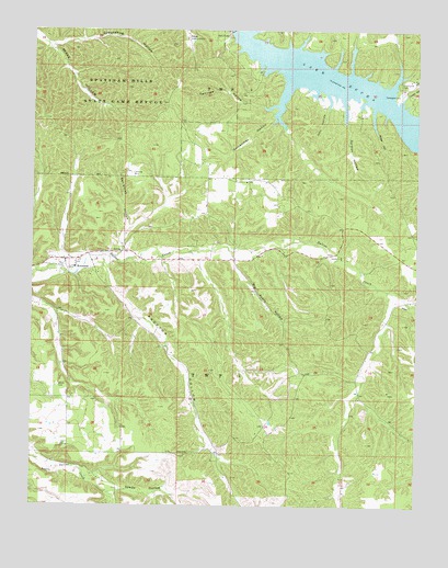
Lake Eucha West, OK USGS Topographic Map
Click on map above to begin viewing in our Map Viewer.

This topographic map contains these locations and features:
Feature Name Type Latitude Longitude GNIS ID View Map
Ben Smith HollowValleyN36.3173°W94.9711°1089998View Map
Big Acorn HollowValleyN36.3142°W94.9344°1090080View Map
Bull HollowCivilN36.3046°W94.9008°2631079View Map
Bull HollowPopulated PlaceN36.3137°W94.9072°1853459View Map
Bull Hollow Census Designated PlaceCensusN36.3046°W94.9008°2407920View Map
Estelle ChurchChurchN36.3156°W94.9000°1092637View Map
Euwasha CemeteryCemeteryN36.3139°W94.9914°2723921View Map
Fairview HollowValleyN36.3554°W94.9216°1092737View Map
Galcatcher HollowValleyN36.3587°W94.9183°1093091View Map
Groundhog HollowValleyN36.3708°W94.9939°1093426View Map
Hail HollowValleyN36.3573°W94.9041°1093479View Map
Hider HollowValleyN36.3534°W94.8899°1093725View Map
Kansas DivisionCivilN36.2620°W94.8957°1937744View Map
KenwoodCivilN36.2934°W94.9889°2631118View Map
KenwoodPopulated PlaceN36.3145°W94.9858°1100552View Map
Kenwood Census Designated PlaceCensusN36.3012°W94.9979°2584383View Map
Kenwood Elementary SchoolSchoolN36.3127°W94.9862°1790759View Map
Kenwood Fire AssociationBuildingN36.3146°W94.9855°2657399View Map
Lane HollowValleyN36.3570°W94.8805°1094502View Map
Old EuchaPopulated PlaceN36.3448°W94.9452°1853475View Map
Old EuchaCivilN36.3558°W94.9378°2631146View Map
Old Eucha CemeteryCemeteryN36.3620°W94.8802°1096235View Map
Old Eucha Census Designated PlaceCensusN36.3551°W94.9379°2408984View Map
Proctor HollowValleyN36.3156°W94.9777°1096937View Map
Public Hunting AreaReserveN36.3397°W94.9192°1763607View Map
Refuge HeadquatersBuildingN36.3729°W94.9508°1763606View Map
Soldier HollowValleyN36.3551°W94.8988°1098190View Map
Spade HollowValleyN36.2540°W94.9719°1098329View Map
Spavinaw Hills State Game RefugeParkN36.3731°W94.9502°1098346View Map
Tagg FlatsPopulated PlaceN36.3393°W94.9255°1853485View Map
Tagg FlatsCivilN36.3387°W94.9036°2631183View Map
Tagg Flats Census Designated PlaceCensusN36.3387°W94.9036°2410049View Map
Welsh CemeteryCemeteryN36.2820°W94.9916°1099486View Map

Note: Coordinates in the location and feature list above are referenced to NAD83 datum.


Copyright (C) 2008-2025 Ryan Niemi / Sunset Dynamics ... All Rights Reserved