TopoQuest Logo
Do you find TopoQuest useful?
Help keep TopoQuest running and adding new maps/features by donating!
Bitcoin:  19c7KJd3qBynnjoSw5npx9KScwjBe4ifkT
Litecoin:  LXs6TkuXGGXo1vDsWCkWVdjQX94eUKd6ui
Home View Maps Find Maps Find Places Resources & Links


Kansas, Oklahoma Topographic Map

USGS Map Title: Kansas, OK
USGS Map MRC: 36094B7
DRG (GeoTIFF) Download: o36094b7.tif


Neighboring USGS Topographic Map Quads:


  Lake Eucha West, OK  
36094C8
 

  Lake Eucha East, OK  
36094C7
 

  Colcord, OK  
36094C6
 

  Leach, OK  
36094B8
 

  Kansas, OK  
36094B7
 

  Siloam Springs NW, OK  
36094B6
 

  Moodys, OK  
36094A8
 

  Chewey, OK  
36094A7
 

  Chance, OK  
36094A6


Map MRC Location:

N37°
W95°
N37°
W94°
H8 H7 H6 H5 H4 H3 H2 H1
G8 G7 G6 G5 G4 G3 G2 G1
F8 F7 F6 F5 F4 F3 F2 F1
E8 E7 E6 E5 E4 E3 E2 E1
D8 D7 D6 D5 D4 D3 D2 D1
C8 C7 C6 C5 C4 C3 C2 C1
B8 B7 B6 B5 B4 B3 B2 B1
A8 A7 A6 A5 A4 A3 A2 A1
N36°
W95°
N36°
W94°

Kansas, OK USGS 1:24K Topographic Map Preview:
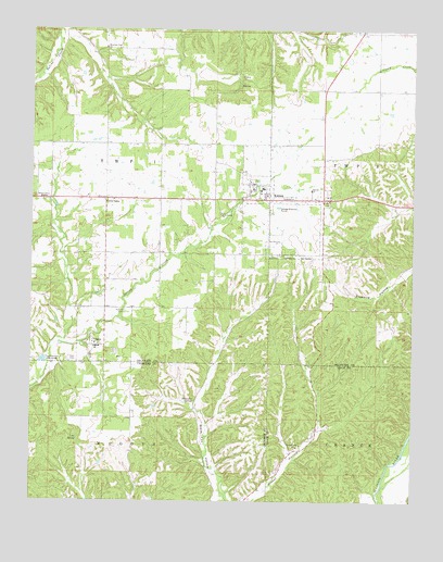
Kansas, OK USGS Topographic Map
Click on map above to begin viewing in our Map Viewer.

This topographic map contains these locations and features:
Feature Name Type Latitude Longitude GNIS ID View Map
Black Fox SpringsSpringN36.1515°W94.8213°1090204View Map
Clear Creek DamDamN36.1701°W94.7519°1751856View Map
Clear Creek LakeReservoirN36.1680°W94.7500°1751857View Map
Cookson Hills Christian SchoolSchoolN36.1409°W94.7847°1091627View Map
Cookson Hills Christian School Airport (historical)AirportN36.1445°W94.7877°1102519View Map
Deer DamDamN36.1468°W94.7736°1751836View Map
Deer LakeReservoirN36.1467°W94.7733°1751837View Map
First Baptist ChurchChurchN36.2093°W94.8025°1798408View Map
Flint Ridge Volunteer Fire DepartmentBuildingN36.1719°W94.7568°2656924View Map
Galilean ChurchChurchN36.2065°W94.7983°1798409View Map
KansasPopulated PlaceN36.2051°W94.7977°1094286View Map
Kansas CemeteryCemeteryN36.2117°W94.8058°2723924View Map
Kansas ChurchChurchN36.2076°W94.7838°1094288View Map
Kansas Elementary SchoolSchoolN36.2076°W94.8003°1793740View Map
Kansas High SchoolSchoolN36.2127°W94.8043°2712907View Map
Kansas Middle SchoolSchoolN36.2127°W94.8043°1790377View Map
Kansas Police DepartmentBuildingN36.2042°W94.7971°2757707View Map
Kansas Volunteer Fire DepartmentBuildingN36.2060°W94.8036°2656906View Map
Long Prairie Baptist ChurchChurchN36.2012°W94.8136°1094915View Map
Long Prairie CemeteryCemeteryN36.2019°W94.8128°2723925View Map
Lost SpringSpringN36.1412°W94.8600°1095013View Map
Mountain View ChurchChurchN36.2454°W94.8516°1095656View Map
Northeast Technology Center Kansas CampusSchoolN36.2098°W94.7784°2712889View Map
OaksPopulated PlaceN36.1662°W94.8547°1096160View Map
Oaks - Mission Elementary SchoolSchoolN36.1659°W94.8532°1803489View Map
Oaks - Mission High SchoolSchoolN36.1648°W94.8540°1794272View Map
Oaks CemeteryCemeteryN36.1629°W94.8627°1096162View Map
Oaks CommunityCivilN36.1429°W94.8604°2631145View Map
Oaks Volunteer Fire DepartmentBuildingN36.1758°W94.8519°2657400View Map
Russell CemeteryCemeteryN36.1754°W94.8447°1097541View Map
Town of KansasCivilN36.2057°W94.7891°2412816View Map
Town of OaksCivilN36.1696°W94.8526°2413069View Map
Twin OaksPopulated PlaceN36.2054°W94.8513°1099119View Map
Twin OaksCivilN36.1926°W94.8217°2631192View Map
Twin Oaks Census Designated PlaceCensusN36.1926°W94.8217°2409375View Map
Walnut Grove MissionChurchN36.2048°W94.8716°1099333View Map

Note: Coordinates in the location and feature list above are referenced to NAD83 datum.


Copyright (C) 2008-2025 Ryan Niemi / Sunset Dynamics ... All Rights Reserved