TopoQuest Logo
Do you find TopoQuest useful?
Help keep TopoQuest running and adding new maps/features by donating!
Bitcoin:  19c7KJd3qBynnjoSw5npx9KScwjBe4ifkT
Litecoin:  LXs6TkuXGGXo1vDsWCkWVdjQX94eUKd6ui
Home View Maps Find Maps Find Places Resources & Links


Lake Geneva, Wisconsin Topographic Map

USGS Map Title: Lake Geneva, WI
USGS Map MRC: 42088E4
DRG (GeoTIFF) Download: o42088e4.tif


Neighboring USGS Topographic Map Quads:


  Elkhorn, WI  
42088F5
 

  Springfield, WI  
42088F4
 

  Burlington, WI  
42088F3
 

  Walworth, WI  
42088E5
 

  Lake Geneva, WI  
42088E4
 

  Genoa City, WI  
42088E3
 

  Harvard, IL  
42088D5
 

  Hebron, IL  
42088D4
 

  Richmond, IL  
42088D3


Map MRC Location:

N43°
W89°
N43°
W88°
H8 H7 H6 H5 H4 H3 H2 H1
G8 G7 G6 G5 G4 G3 G2 G1
F8 F7 F6 F5 F4 F3 F2 F1
E8 E7 E6 E5 E4 E3 E2 E1
D8 D7 D6 D5 D4 D3 D2 D1
C8 C7 C6 C5 C4 C3 C2 C1
B8 B7 B6 B5 B4 B3 B2 B1
A8 A7 A6 A5 A4 A3 A2 A1
N42°
W89°
N42°
W88°

Lake Geneva, WI USGS 1:24K Topographic Map Preview:
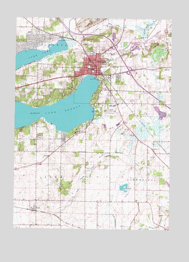
Lake Geneva, WI USGS Topographic Map
Click on map above to begin viewing in our Map Viewer.

This topographic map contains these locations and features:
Feature Name Type Latitude Longitude GNIS ID View Map
3 ReservoirReservoirN42.5695°W88.3834°1792509View Map
Badger High SchoolSchoolN42.5731°W88.4201°1561068View Map
Big Foot Beach State ParkParkN42.5697°W88.4234°1561724View Map
Buttons BayBayN42.5689°W88.4382°1851225View Map
Central - Denison Elementary SchoolSchoolN42.5946°W88.4380°1851229View Map
Ceylon LagoonLakeN42.5696°W88.4361°1562914View Map
Church of the Holy CommunionChurchN42.5934°W88.4357°1851231View Map
City of Lake GenevaCivilN42.5825°W88.4282°1583511View Map
ComoPopulated PlaceN42.6122°W88.4823°1563298View Map
Como Census Designated PlaceCensusN42.6114°W88.4913°2393383View Map
Como CreekStreamN42.6195°W88.3968°1563299View Map
Denison Middle SchoolSchoolN42.5947°W88.4379°1563902View Map
Eastview Elementary SchoolSchoolN42.5961°W88.4315°1564386View Map
Elm ParkParkN42.5914°W88.4390°1851249View Map
First Baptist ChurchChurchN42.5934°W88.4351°1851258View Map
First Church of Christ ScientistChurchN42.5939°W88.4351°1851259View Map
First Congregational ChurchChurchN42.5942°W88.4348°1851261View Map
First Evangelical Lutheran ChurchChurchN42.5989°W88.4295°1851264View Map
First Lutheran SchoolSchoolN42.6045°W88.4411°2716865View Map
First Methodist ChurchChurchN42.5928°W88.4373°1851266View Map
Flatiron ParkParkN42.5897°W88.4340°1851270View Map
Geneva BayBayN42.5870°W88.4404°1851277View Map
Geneva Police DepartmentBuildingN42.6192°W88.4868°2759436View Map
Grand Geneva Resort AirportAirportN42.6125°W88.3951°2444200View Map
Grethe G2481 DamDamN42.5734°W88.3884°1792508View Map
Hillmoor Country ClubLocaleN42.5964°W88.4226°1581235View Map
Lake ComoReservoirN42.5998°W88.4916°1563301View Map
Lake GenevaPopulated PlaceN42.5917°W88.4334°1581223View Map
Lake Geneva Bible ChapelChurchN42.5992°W88.4323°1851287View Map
Lake Geneva City HallBuildingN42.5920°W88.4323°1851288View Map
Lake Geneva DamDamN42.5900°W88.4351°1791824View Map
Lake Geneva Fire Department Station 1BuildingN42.5986°W88.4347°2698021View Map
Lake Geneva Fire Department Station 2BuildingN42.5792°W88.4172°2698083View Map
Lake Geneva Middle SchoolSchoolN42.5736°W88.4145°2716881View Map
Lake Geneva MuseumBuildingN42.5928°W88.4362°1851289View Map
Lake Geneva Police DepartmentBuildingN42.5927°W88.4327°2759542View Map
Lake Geneva Post OfficePost OfficeN42.5914°W88.4331°1851290View Map
Lake Geneva Public LibraryBuildingN42.5914°W88.4376°1851291View Map
Lake Geneva Wastewater Treatment PlantLocaleN42.6008°W88.4253°2709437View Map
LHW HeliportAirportN42.5584°W88.4398°1582045View Map
Linn Police DepartmentBuildingN42.5133°W88.4832°2759527View Map
Locust Grove SchoolSchoolN42.5461°W88.4432°1568485View Map
Mannings PointCapeN42.5742°W88.4404°1851296View Map
Maple ParkParkN42.5936°W88.4379°1851297View Map
Medix Ambulance Services Lake GenevaBuildingN42.5919°W88.4320°2698439View Map
Moelter PondLakeN42.6062°W88.3826°2764441View Map
Moss ParkParkN42.5997°W88.4390°1851305View Map
Mount Zion Christian SchoolSchoolN42.6218°W88.4149°2716237View Map
Oak Hill CemeteryCemeteryN42.6072°W88.4404°1570635View Map
Old Bloomfield CemeteryCemeteryN42.5175°W88.4018°2002808View Map
Peterkin PondLakeN42.5260°W88.4121°1571257View Map
Pioneer CemeteryCemeteryN42.5963°W88.4411°1571538View Map
Pioneer EstatesPopulated PlaceN42.5650°W88.4106°2508619View Map
Queen of Peace MonasteryChurchN42.5592°W88.4504°1571999View Map
Ryan PitMineN42.6106°W88.4419°2634048View Map
Saint Francis de Sales Roman Catholic ChurchChurchN42.5914°W88.4245°1851321View Map
Saint Francis de Sales SchoolSchoolN42.5912°W88.4240°1851322View Map
Saint Francis Desales CemeteryCemeteryN42.5958°W88.3752°1572925View Map
Seminary ParkParkN42.5886°W88.4312°1851333View Map
Shady Side (historical)Populated PlaceN42.5647°W88.4373°1851335View Map
The NarrowsGapN42.5686°W88.4787°1575334View Map
Town of BloomfieldCivilN42.5224°W88.3940°1582832View Map
Town of LinnCivilN42.5371°W88.4828°1583576View Map
Town of Linn Fire and Emergency Medical ServicesBuildingN42.5439°W88.4631°2698044View Map
Traver Elementary SchoolSchoolN42.5434°W88.4725°1575604View Map
WMIR-AM (Lake Geneva)TowerN42.5945°W88.3887°1582313View Map
Woods Elementary SchoolSchoolN42.5842°W88.4639°2716177View Map
ZendaPopulated PlaceN42.5120°W88.4818°1577124View Map

Note: Coordinates in the location and feature list above are referenced to NAD83 datum.


Copyright (C) 2008-2025 Ryan Niemi / Sunset Dynamics ... All Rights Reserved