TopoQuest Logo
Do you find TopoQuest useful?
Help keep TopoQuest running and adding new maps/features by donating!
Bitcoin:  19c7KJd3qBynnjoSw5npx9KScwjBe4ifkT
Litecoin:  LXs6TkuXGGXo1vDsWCkWVdjQX94eUKd6ui
Home View Maps Find Maps Find Places Resources & Links


Lake Merritt, Texas Topographic Map

USGS Map Title: Lake Merritt, TX
USGS Map MRC: 31098E5
DRG (GeoTIFF) Download: o31098e5.tif


Neighboring USGS Topographic Map Quads:


  Democrat, TX  
31098F6
 

  Priddy, TX  
31098F5
 

  Indian Gap, TX  
31098F4
 

  Mullin, TX  
31098E6
 

  Lake Merritt, TX  
31098E5
 

  Caradan, TX  
31098E4
 

  Big Valley North, TX  
31098D6
 

  Goldthwaite, TX  
31098D5
 

  Center City, TX  
31098D4


Map MRC Location:

N32°
W99°
N32°
W98°
H8 H7 H6 H5 H4 H3 H2 H1
G8 G7 G6 G5 G4 G3 G2 G1
F8 F7 F6 F5 F4 F3 F2 F1
E8 E7 E6 E5 E4 E3 E2 E1
D8 D7 D6 D5 D4 D3 D2 D1
C8 C7 C6 C5 C4 C3 C2 C1
B8 B7 B6 B5 B4 B3 B2 B1
A8 A7 A6 A5 A4 A3 A2 A1
N31°
W99°
N31°
W98°

Lake Merritt, TX USGS 1:24K Topographic Map Preview:
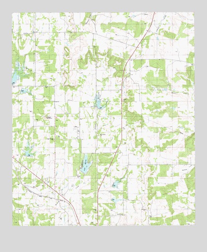
Lake Merritt, TX USGS Topographic Map
Click on map above to begin viewing in our Map Viewer.

This topographic map contains these locations and features:
Feature Name Type Latitude Longitude GNIS ID View Map
BozarPopulated PlaceN31.5168°W98.5970°1377172View Map
Brown Mullin Watershed Reservoir Number FiveReservoirN31.5693°W98.5647°1352975View Map
Brown Mullin Watershed Reservoir Number SevenReservoirN31.5151°W98.5558°1352977View Map
Brown Mullin Watershed Reservoir Number SixReservoirN31.5245°W98.5548°1352976View Map
Brown Mullin Watershed Reservoir Number TwoReservoirN31.5865°W98.6241°1352974View Map
Browns Mullin Watershed Reservoir Number FourReservoirN31.5796°W98.6192°1353001View Map
Lake MerrittReservoirN31.5352°W98.5753°1362638View Map
Lake Merritt DamDamN31.5302°W98.5787°1860790View Map
Mullin-Priddy DivisionCivilN31.5419°W98.5995°1939019View Map
North Browns CemeteryCemeteryN31.5535°W98.5659°1364004View Map
Soil Conservation Service Site 3 DamDamN31.5802°W98.6203°1860770View Map
Soil Conservation Service Site 3 ReservoirReservoirN31.5802°W98.6203°1860771View Map
Soil Conservation Service Site 4 DamDamN31.5418°W98.6137°1860772View Map
Soil Conservation Service Site 4 ReservoirReservoirN31.5423°W98.6147°1860773View Map
Soil Conservation Service Site 5a DamDamN31.5702°W98.5670°1860774View Map
Soil Conservation Service Site 6 DamDamN31.5235°W98.5603°1860776View Map
Soil Conservation Service Site 6 ReservoirReservoirN31.5235°W98.5603°1860777View Map
Soil Conservation Service Site 7 DamDamN31.5152°W98.5603°1860778View Map
Soil Conservation Service Site 7 ReservoirReservoirN31.5151°W98.5606°1860779View Map
Tiger MountainSummitN31.5638°W98.6020°1369936View Map
Trigger Mountain CemeteryCemeteryN31.5510°W98.5967°1370115View Map

Note: Coordinates in the location and feature list above are referenced to NAD83 datum.


Copyright (C) 2008-2024 Ryan Niemi / Sunset Dynamics ... All Rights Reserved