TopoQuest Logo
Do you find TopoQuest useful?
Help keep TopoQuest running and adding new maps/features by donating!
Bitcoin:  19c7KJd3qBynnjoSw5npx9KScwjBe4ifkT
Litecoin:  LXs6TkuXGGXo1vDsWCkWVdjQX94eUKd6ui
Home View Maps Find Maps Find Places Resources & Links


Big Valley North, Texas Topographic Map

USGS Map Title: Big Valley North, TX
USGS Map MRC: 31098D6
DRG (GeoTIFF) Download: o31098d6.tif


Neighboring USGS Topographic Map Quads:


  Blanket Springs, TX  
31098E7
 

  Mullin, TX  
31098E6
 

  Lake Merritt, TX  
31098E5
 

  Regency, TX  
31098D7
 

  Big Valley North, TX  
31098D6
 

  Goldthwaite, TX  
31098D5
 

  Blucher Mountain, TX  
31098C7
 

  Big Valley South, TX  
31098C6
 

  San Saba Peak, TX  
31098C5


Map MRC Location:

N32°
W99°
N32°
W98°
H8 H7 H6 H5 H4 H3 H2 H1
G8 G7 G6 G5 G4 G3 G2 G1
F8 F7 F6 F5 F4 F3 F2 F1
E8 E7 E6 E5 E4 E3 E2 E1
D8 D7 D6 D5 D4 D3 D2 D1
C8 C7 C6 C5 C4 C3 C2 C1
B8 B7 B6 B5 B4 B3 B2 B1
A8 A7 A6 A5 A4 A3 A2 A1
N31°
W99°
N31°
W98°

Big Valley North, TX USGS 1:24K Topographic Map Preview:
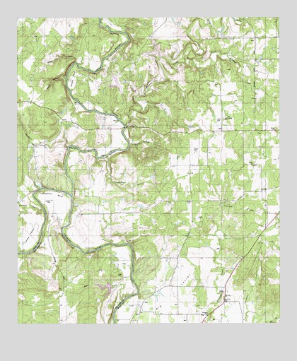
Big Valley North, TX USGS Topographic Map
Click on map above to begin viewing in our Map Viewer.

This topographic map contains these locations and features:
Feature Name Type Latitude Longitude GNIS ID View Map
Barnett LakeReservoirN31.4218°W98.7387°1864034View Map
Barnett Lake DamDamN31.4218°W98.7387°1864033View Map
Big ValleyPopulated PlaceN31.3896°W98.6525°2034964View Map
Big Valley CemeteryCemeteryN31.3846°W98.6517°1352174View Map
Big Valley ChurchChurchN31.3860°W98.6517°1352176View Map
Blue BluffCliffN31.3885°W98.6739°1889810View Map
Browns CreekStreamN31.4557°W98.6984°1352999View Map
Catclaw CemeteryCemeteryN31.4252°W98.7342°1353966View Map
Cedar HollowValleyN31.4482°W98.6968°1354117View Map
Chambers CreekStreamN31.4474°W98.7262°1373048View Map
Crooked RunStreamN31.4218°W98.7378°1355389View Map
Estep CemeteryCemeteryN31.3954°W98.7023°1357083View Map
Gibbs HollowValleyN31.4751°W98.7268°1357994View Map
Grindstone HollowValleyN31.4433°W98.7087°1373931View Map
Horseshoe BendBendN31.4277°W98.7345°1359626View Map
Jones CanyonValleyN31.4840°W98.7195°1360380View Map
Mullin CreekStreamN31.4963°W98.6578°1363469View Map
Pecan BayouStreamN31.4271°W98.7239°1375387View Map
Rock Spring CemeteryCemeteryN31.4588°W98.6517°1366698View Map
Rock SpringsSpringN31.4579°W98.6550°1889809View Map
Smoky BendBendN31.4757°W98.7237°1368517View Map
Smoky Bend AirportAirportN31.4753°W98.7029°1387231View Map
South Browns CreekStreamN31.4818°W98.6706°1368643View Map
Traylor CemeteryCemeteryN31.4457°W98.6653°1370096View Map
Waco CreekStreamN31.3863°W98.6973°1370702View Map
Well SpringSpringN31.4593°W98.6500°1890030View Map

Note: Coordinates in the location and feature list above are referenced to NAD83 datum.


Copyright (C) 2008-2024 Ryan Niemi / Sunset Dynamics ... All Rights Reserved