TopoQuest Logo
Do you find TopoQuest useful?
Help keep TopoQuest running and adding new maps/features by donating!
Bitcoin:  19c7KJd3qBynnjoSw5npx9KScwjBe4ifkT
Litecoin:  LXs6TkuXGGXo1vDsWCkWVdjQX94eUKd6ui
Home View Maps Find Maps Find Places Resources & Links


Lake Nebagamon, Wisconsin Topographic Map

USGS Map Title: Lake Nebagamon, WI
USGS Map MRC: 46091E6
DRG (GeoTIFF) Download: o46091e6.tif


Neighboring USGS Topographic Map Quads:


  Poplar NE, WI  
46091F7
 

  Cloverland, WI  
46091F6
 

  Oulu, WI  
46091F5
 

  Poplar, WI  
46091E7
 

  Lake Nebagamon, WI  
46091E6
 

  Brule, WI  
46091E5
 

  Bennett, WI  
46091D7
 

  Lake Minnesuing, WI  
46091D6
 

  Island Lake, WI  
46091D5


Map MRC Location:

N47°
W92°
N47°
W91°
H8 H7 H6 H5 H4 H3 H2 H1
G8 G7 G6 G5 G4 G3 G2 G1
F8 F7 F6 F5 F4 F3 F2 F1
E8 E7 E6 E5 E4 E3 E2 E1
D8 D7 D6 D5 D4 D3 D2 D1
C8 C7 C6 C5 C4 C3 C2 C1
B8 B7 B6 B5 B4 B3 B2 B1
A8 A7 A6 A5 A4 A3 A2 A1
N46°
W92°
N46°
W91°

Lake Nebagamon, WI USGS 1:24K Topographic Map Preview:
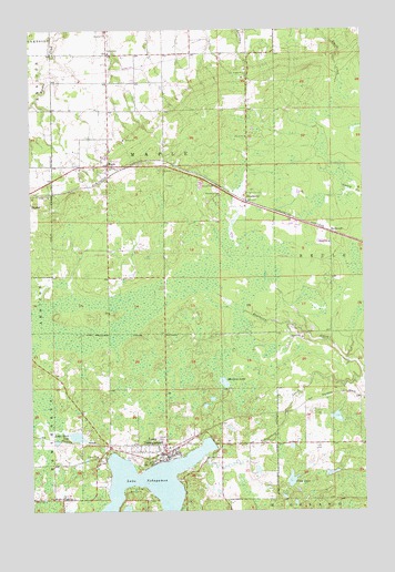
Lake Nebagamon, WI USGS Topographic Map
Click on map above to begin viewing in our Map Viewer.

This topographic map contains these locations and features:
Feature Name Type Latitude Longitude GNIS ID View Map
BellwoodPopulated PlaceN46.5719°W91.6377°1577513View Map
BlueberryPopulated PlaceN46.5802°W91.6688°1561962View Map
Blueberry CemeteryCemeteryN46.5824°W91.6788°1561963View Map
Blueberry CreekStreamN46.5333°W91.6260°1561964View Map
Corner SchoolSchoolN46.6191°W91.7202°1563411View Map
Finnish ChurchChurchN46.6238°W91.7213°1564953View Map
Lake NebagamonLakeN46.5025°W91.7013°1570127View Map
Lake NebagamonPopulated PlaceN46.5149°W91.6999°1567743View Map
Lake Nebagamon ChurchChurchN46.5036°W91.7421°1567744View Map
Lake Nebagamon Police DepartmentBuildingN46.5135°W91.6995°2759776View Map
Lake Nebagamon Volunteer Fire DepartmentBuildingN46.5153°W91.7030°2696809View Map
Little Steele LakeLakeN46.5193°W91.7335°1568428View Map
Lydon LakeLakeN46.5005°W91.7150°1568831View Map
MaplePopulated PlaceN46.5897°W91.7207°1568957View Map
Maple Fire DepartmentBuildingN46.5903°W91.7308°2696735View Map
Minnow LakeLakeN46.5334°W91.6781°1569577View Map
Northwestern High SchoolSchoolN46.5918°W91.7217°2713201View Map
Pine LakeLakeN46.5079°W91.6530°1571501View Map
Town of MapleCivilN46.6043°W91.7000°1583639View Map
Village of Lake NebagamonCivilN46.5119°W91.6995°1583516View Map

Note: Coordinates in the location and feature list above are referenced to NAD83 datum.


Copyright (C) 2008-2024 Ryan Niemi / Sunset Dynamics ... All Rights Reserved