TopoQuest Logo
Do you find TopoQuest useful?
Help keep TopoQuest running and adding new maps/features by donating!
Bitcoin:  19c7KJd3qBynnjoSw5npx9KScwjBe4ifkT
Litecoin:  LXs6TkuXGGXo1vDsWCkWVdjQX94eUKd6ui
Home View Maps Find Maps Find Places Resources & Links


Lake Shastina, California Topographic Map

USGS Map Title: Lake Shastina, CA
USGS Map MRC: 41122E4
DRG (GeoTIFF) Download: o41122e4.tif


Neighboring USGS Topographic Map Quads:


  Montague, CA  
41122F5
 

  Little Shasta, CA  
41122F4
 

  Solomons Temple, CA  
41122F3
 

  Gazelle, CA  
41122E5
 

  Lake Shastina, CA  
41122E4
 

  Juniper Flat, CA  
41122E3
 

  China Mountain, CA  
41122D5
 

  Weed, CA  
41122D4
 

  Hotlum, CA  
41122D3


Map MRC Location:

N42°
W123°
N42°
W122°
H8 H7 H6 H5 H4 H3 H2 H1
G8 G7 G6 G5 G4 G3 G2 G1
F8 F7 F6 F5 F4 F3 F2 F1
E8 E7 E6 E5 E4 E3 E2 E1
D8 D7 D6 D5 D4 D3 D2 D1
C8 C7 C6 C5 C4 C3 C2 C1
B8 B7 B6 B5 B4 B3 B2 B1
A8 A7 A6 A5 A4 A3 A2 A1
N41°
W123°
N41°
W122°

Lake Shastina, CA USGS 1:24K Topographic Map Preview:
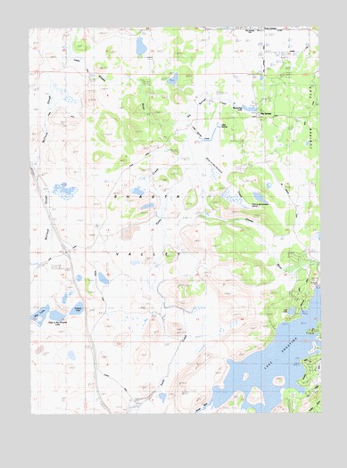
Lake Shastina, CA USGS Topographic Map
Click on map above to begin viewing in our Map Viewer.

This topographic map contains these locations and features:
Feature Name Type Latitude Longitude GNIS ID View Map
Big LakeReservoirN41.5320°W122.4982°1657745View Map
Big SpringsPopulated PlaceN41.5954°W122.4050°257020View Map
Big Springs CreekStreamN41.5935°W122.4386°1657747View Map
Big Springs Elementary SchoolSchoolN41.6246°W122.4057°257030View Map
Big Springs LakeReservoirN41.5984°W122.4065°1657748View Map
Carrick CreekStreamN41.5007°W122.4109°260493View Map
Copco SubstationLocaleN41.6046°W122.4056°1654214View Map
Dukes RanchLocaleN41.5326°W122.4475°1682297View Map
Four CornersLocaleN41.6240°W122.4011°260295View Map
Freeway LakeReservoirN41.5339°W122.4808°1657770View Map
Hole in the Ground CreekStreamN41.5826°W122.4306°1657783View Map
Hole in the Ground LakeReservoirN41.5317°W122.4896°1657784View Map
Hole in the Ground SpringSpringN41.5672°W122.4059°1657785View Map
Lake ShastinaReservoirN41.5231°W122.3901°267233View Map
Little SpringsSpringN41.5926°W122.4192°1657802View Map
Little Springs CreekStreamN41.5963°W122.4334°1657803View Map
Lost LakeLakeN41.5326°W122.3892°1657805View Map
Lost LakeLakeN41.5327°W122.3891°227710View Map
Mayten Fire Protection DistrictBuildingN41.6236°W122.4065°2622124View Map
McCloud SloughGutN41.5760°W122.4975°1657807View Map
Parks CreekStreamN41.5890°W122.4330°264532View Map
Shasta River 60-000 DamDamN41.5413°W122.3761°1663477View Map

Note: Coordinates in the location and feature list above are referenced to NAD83 datum.


Copyright (C) 2008-2025 Ryan Niemi / Sunset Dynamics ... All Rights Reserved