TopoQuest Logo
Do you find TopoQuest useful?
Help keep TopoQuest running and adding new maps/features by donating!
Bitcoin:  19c7KJd3qBynnjoSw5npx9KScwjBe4ifkT
Litecoin:  LXs6TkuXGGXo1vDsWCkWVdjQX94eUKd6ui
Home View Maps Find Maps Find Places Resources & Links


Lamar, Oklahoma Topographic Map

USGS Map Title: Lamar, OK
USGS Map MRC: 35096A2
DRG (GeoTIFF) Download: o35096a2.tif


Neighboring USGS Topographic Map Quads:


  Yeager, OK  
35096B3
 

  Wetumka, OK  
35096B2
 

  Carson, OK  
35096B1
 

  Lake Holdenville, OK  
35096A3
 

  Lamar, OK  
35096A2
 

  Wetumka SE, OK  
35096A1
 

  Calvin West, OK  
34096H3
 

  Calvin East, OK  
34096H2
 

  Stuart, OK  
34096H1


Map MRC Location:

N36°
W97°
N36°
W96°
H8 H7 H6 H5 H4 H3 H2 H1
G8 G7 G6 G5 G4 G3 G2 G1
F8 F7 F6 F5 F4 F3 F2 F1
E8 E7 E6 E5 E4 E3 E2 E1
D8 D7 D6 D5 D4 D3 D2 D1
C8 C7 C6 C5 C4 C3 C2 C1
B8 B7 B6 B5 B4 B3 B2 B1
A8 A7 A6 A5 A4 A3 A2 A1
N35°
W97°
N35°
W96°

Lamar, OK USGS 1:24K Topographic Map Preview:
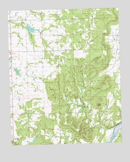
Lamar, OK USGS Topographic Map
Click on map above to begin viewing in our Map Viewer.

This topographic map contains these locations and features:
Feature Name Type Latitude Longitude GNIS ID View Map
Coal CreekStreamN35.0156°W96.1314°1091495View Map
Cross RoadsPopulated PlaceN35.0065°W96.2478°1100335View Map
Crossroads CemeteryCemeteryN35.0064°W96.2408°2711569View Map
Hack Black Junior DamDamN35.0134°W96.1503°1754148View Map
Hack Black Junior ReservoirReservoirN35.0134°W96.1503°1754149View Map
HorntownPopulated PlaceN35.0870°W96.2478°1093929View Map
Horntown Rural Fire DistrictBuildingN35.0841°W96.2473°2657486View Map
Hughes County Emergency Medical Services Station 2BuildingN35.0840°W96.2473°2695946View Map
LamarPopulated PlaceN35.0995°W96.1275°1094486View Map
Lamar MountainSummitN35.0795°W96.1406°1094488View Map
Lamar Volunteer Fire DepartmentBuildingN35.0982°W96.1274°2657252View Map
Little Wewoka Creek Site 13 DamDamN35.0701°W96.2453°1750914View Map
Little Wewoka Creek Site 13 ReservoirReservoirN35.0701°W96.2453°1750915View Map
Little Wewoka Creek Site 14 DamDamN35.1101°W96.2286°1750912View Map
Little Wewoka Creek Site 14 ReservoirReservoirN35.1101°W96.2286°1750913View Map
McMahan CemeteryCemeteryN35.0801°W96.2119°1095271View Map
Moss Elementary SchoolSchoolN35.0719°W96.2306°1095543View Map
Moss High SchoolSchoolN35.0720°W96.2320°2713149View Map
Oknoname 063025 DamDamN35.0034°W96.2303°1752969View Map
Oknoname 063025 ReservoirReservoirN35.0032°W96.2317°1752970View Map
Oknoname 063026 DamDamN35.0068°W96.2236°1752971View Map
Oknoname 063026 ReservoirReservoirN35.0053°W96.2239°1752972View Map
Spring Creek CemeteryCemeteryN35.0002°W96.1911°1098426View Map
Tabletop MountainSummitN35.0356°W96.1500°1098712View Map
Town of HorntownCivilN35.0869°W96.2476°2412768View Map
Township of BarnardCivilN35.0779°W96.1808°1824952View Map

Note: Coordinates in the location and feature list above are referenced to NAD83 datum.


Copyright (C) 2008-2024 Ryan Niemi / Sunset Dynamics ... All Rights Reserved