TopoQuest Logo
Do you find TopoQuest useful?
Help keep TopoQuest running and adding new maps/features by donating!
Bitcoin:  19c7KJd3qBynnjoSw5npx9KScwjBe4ifkT
Litecoin:  LXs6TkuXGGXo1vDsWCkWVdjQX94eUKd6ui
Home View Maps Find Maps Find Places Resources & Links


Latta, South Carolina Topographic Map

USGS Map Title: Latta, SC
USGS Map MRC: 34079C4
DRG (GeoTIFF) Download: o34079c4.tif


Neighboring USGS Topographic Map Quads:


  Bingham, SC  
34079D5
 

  Dillon West, SC  
34079D4
 

  Dillon East, SC  
34079D3
 

  Oak Grove, SC  
34079C5
 

  Latta, SC  
34079C4
 

  Fork, SC  
34079C3
 

  Pee Dee, SC  
34079B5
 

  Marion, SC  
34079B4
 

  Mullins, SC  
34079B3


Map MRC Location:

N35°
W80°
N35°
W79°
H8 H7 H6 H5 H4 H3 H2 H1
G8 G7 G6 G5 G4 G3 G2 G1
F8 F7 F6 F5 F4 F3 F2 F1
E8 E7 E6 E5 E4 E3 E2 E1
D8 D7 D6 D5 D4 D3 D2 D1
C8 C7 C6 C5 C4 C3 C2 C1
B8 B7 B6 B5 B4 B3 B2 B1
A8 A7 A6 A5 A4 A3 A2 A1
N34°
W80°
N34°
W79°

Latta, SC USGS 1:24K Topographic Map Preview:
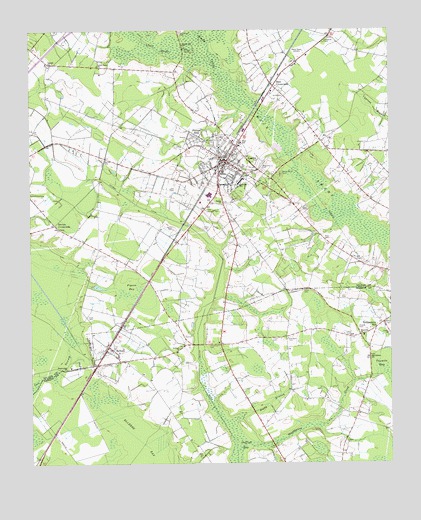
Latta, SC USGS Topographic Map
Click on map above to begin viewing in our Map Viewer.

This topographic map contains these locations and features:
Feature Name Type Latitude Longitude GNIS ID View Map
Allen CemeteryCemeteryN34.3152°W79.3973°1220160View Map
Antioch Baptist ChurchChurchN34.2835°W79.4481°1220217View Map
Bass CemeteryCemeteryN34.3196°W79.4284°1220343View Map
Bass CrossroadsPopulated PlaceN34.3588°W79.4148°1220348View Map
Berean Church of ChristChurchN34.3340°W79.4389°1236074View Map
Berrys CrossroadsPopulated PlaceN34.3190°W79.4912°1246753View Map
Bethea CemeteryCemeteryN34.3379°W79.4731°1220534View Map
Bethea Cross RoadsLocaleN34.3632°W79.4492°1236076View Map
Betheas CrossroadsLocaleN34.3432°W79.3984°1236079View Map
Bethel Hill CemeteryCemeteryN34.3749°W79.4474°1220578View Map
Bethel Hill ChurchChurchN34.3710°W79.4462°1246803View Map
Bethlehem ChurchChurchN34.2804°W79.3814°1220615View Map
Bethlehem School (historical)SchoolN34.2802°W79.3820°1230783View Map
Boggy BranchStreamN34.2613°W79.4326°1220857View Map
Bright Star ChurchChurchN34.2777°W79.4873°1220960View Map
Bryant CemeteryCemeteryN34.2902°W79.3764°1221054View Map
Catfish ChurchChurchN34.3654°W79.4926°1247190View Map
Catfish Creek Baptist Church CemeteryCemeteryN34.3652°W79.4920°1964694View Map
Christmas CemeteryCemeteryN34.2843°W79.4378°1221582View Map
DalchoPopulated PlaceN34.3657°W79.4931°1248767View Map
Dalcho High School (historical)SchoolN34.3657°W79.4937°1236086View Map
Dillon County LibraryBuildingN34.3388°W79.4346°2490363View Map
Dillon Fire Department Station 2BuildingN34.3389°W79.4327°2368306View Map
Ebenezer CemeteryCemeteryN34.2860°W79.4103°1222208View Map
Ebenezer ChurchChurchN34.2871°W79.3856°1247617View Map
Forrest HillsPopulated PlaceN34.3446°W79.4426°1231290View Map
Holiness Church (historical)ChurchN34.3396°W79.3803°1236119View Map
Hulon CemeteryCemeteryN34.3179°W79.4395°1223389View Map
Lane CemeteryCemeteryN34.2863°W79.3889°1223802View Map
Lane CemeteryCemeteryN34.3002°W79.4048°1223803View Map
Lane CemeteryCemeteryN34.3232°W79.4031°1223804View Map
Lane CemeteryCemeteryN34.3293°W79.4512°1223805View Map
LattaPopulated PlaceN34.3371°W79.4312°1246298View Map
Latta DivisionCivilN34.3415°W79.4847°1938328View Map
Latta High SchoolSchoolN34.3427°W79.4264°1236133View Map
Latta Historic District Number 1ParkN34.3404°W79.4353°1236132View Map
Latta Historic District Number 2ParkN34.3385°W79.4303°1236134View Map
Latta Logan Pond Dam D-3604DamN34.3402°W79.4131°1240084View Map
Latta Lookout TowerTowerN34.3238°W79.4384°1242434View Map
Latta Police DepartmentBuildingN34.3387°W79.4325°2334957View Map
Latta Post OfficePost OfficeN34.3381°W79.4336°1252208View Map
Latta Presbyterian ChurchChurchN34.3377°W79.4306°1236135View Map
Latta Primary SchoolSchoolN34.3418°W79.4270°1236136View Map
Lattimer SchoolSchoolN34.3315°W79.4264°1246299View Map
Lee CemeteryCemeteryN34.2974°W79.3917°1223862View Map
Level Green ChurchChurchN34.3649°W79.4756°1246337View Map
Level Green School (historical)SchoolN34.3640°W79.4703°1236138View Map
Little Reedy CreekStreamN34.3685°W79.4417°1224029View Map
Mace CemeteryCemeteryN34.2927°W79.4801°1224239View Map
Magnolia CemeteryCemeteryN34.3346°W79.4187°1224269View Map
Manning School (historical)SchoolN34.3679°W79.3825°1236148View Map
Meadow Hill School (historical)SchoolN34.2854°W79.4345°1230821View Map
Moody CemeteryCemeteryN34.2565°W79.3906°1224628View Map
New Hope Baptist ChurchChurchN34.3310°W79.4339°1236162View Map
New Hope School (historical)SchoolN34.3646°W79.4759°1237436View Map
New Mount Zion African Methodist Episcopal ChurchChurchN34.2821°W79.4693°2490304View Map
Oakey Point CemeteryCemeteryN34.3332°W79.4123°1225138View Map
Old Ebenezer ChurchChurchN34.2863°W79.4106°1230835View Map
Pigeon BaySwampN34.2996°W79.4654°1225413View Map
Powers CemeteryCemeteryN34.2890°W79.3859°1225656View Map
Reedy CreekStreamN34.3602°W79.4323°1225818View Map
Saint John Baptist ChurchChurchN34.3371°W79.4373°1236179View Map
Sardis Baptist ChurchChurchN34.3249°W79.4328°1250790View Map
Sardis Baptist Church CemeteryCemeteryN34.3252°W79.4328°1964706View Map
Sardis Indian School (historical)SchoolN34.3249°W79.4328°1236182View Map
SellersPopulated PlaceN34.2838°W79.4728°1231789View Map
Sellers Chapel Baptist ChurchChurchN34.2808°W79.4699°2490313View Map
Sellers Indian School (historical)SchoolN34.2779°W79.4862°1236183View Map
Stackhouse CreekStreamN34.2535°W79.4284°1226857View Map
Sweat CemeteryCemeteryN34.3182°W79.4498°1226989View Map
Temperance HillPopulated PlaceN34.2888°W79.3798°1231855View Map
Temperance Hill Fire DepartmentBuildingN34.2875°W79.3851°2368378View Map
Town of LattaCivilN34.3390°W79.4336°2405989View Map
Town of SellersCivilN34.2823°W79.4722°2407309View Map
Turner CemeteryCemeteryN34.2863°W79.4162°1227253View Map
Turner CemeteryCemeteryN34.3115°W79.4395°1227254View Map
Union ChurchChurchN34.2874°W79.3753°1251257View Map
Vidalia Academy (historical)SchoolN34.3365°W79.4273°1236191View Map
WDSC-AM (Dillon)TowerN34.3699°W79.4020°1252338View Map

Note: Coordinates in the location and feature list above are referenced to NAD83 datum.


Copyright (C) 2008-2025 Ryan Niemi / Sunset Dynamics ... All Rights Reserved