TopoQuest Logo
Do you find TopoQuest useful?
Help keep TopoQuest running and adding new maps/features by donating!
Bitcoin:  19c7KJd3qBynnjoSw5npx9KScwjBe4ifkT
Litecoin:  LXs6TkuXGGXo1vDsWCkWVdjQX94eUKd6ui
Home View Maps Find Maps Find Places Resources & Links


Lawrenceburg, Indiana Topographic Map

USGS Map Title: Lawrenceburg, IN
USGS Map MRC: 39084A7
DRG (GeoTIFF) Download: o39084a7.tif


Neighboring USGS Topographic Map Quads:


  Guilford, IN  
39084B8
 

  Hooven, OH  
39084B7
 

  Addyston, OH  
39084B6
 

  Aurora, IN  
39084A8
 

  Lawrenceburg, IN  
39084A7
 

  Burlington, KY  
39084A6
 

  Aberdeen, IN  
38084H8
 

  Rising Sun, IN  
38084H7
 

  Union, KY  
38084H6


Map MRC Location:

N40°
W85°
N40°
W84°
H8 H7 H6 H5 H4 H3 H2 H1
G8 G7 G6 G5 G4 G3 G2 G1
F8 F7 F6 F5 F4 F3 F2 F1
E8 E7 E6 E5 E4 E3 E2 E1
D8 D7 D6 D5 D4 D3 D2 D1
C8 C7 C6 C5 C4 C3 C2 C1
B8 B7 B6 B5 B4 B3 B2 B1
A8 A7 A6 A5 A4 A3 A2 A1
N39°
W85°
N39°
W84°

Lawrenceburg, IN USGS 1:24K Topographic Map Preview:
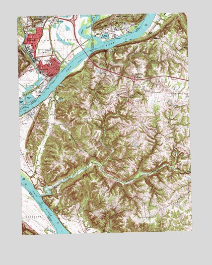
Lawrenceburg, IN USGS Topographic Map
Click on map above to begin viewing in our Map Viewer.

This topographic map contains these locations and features:
Feature Name Type Latitude Longitude GNIS ID View Map
Allen ForkStreamN39.0362°W84.7647°485869View Map
Ashbys ForkStreamN39.0384°W84.8152°486079View Map
Barnard CemeteryCemeteryN39.1045°W84.8086°486377View Map
Botts CemeteryCemeteryN39.0784°W84.8030°487722View Map
Brandywine CreekStreamN39.0323°W84.7872°487828View Map
Brown CemeteryCemeteryN39.1239°W84.7699°488001View Map
Bullitsburg ChurchChurchN39.0901°W84.7877°488372View Map
City of GreendaleCivilN39.1234°W84.8612°2394982View Map
City of LawrenceburgCivilN39.0986°W84.8713°2395648View Map
Commissary CornerPopulated PlaceN39.0087°W84.7838°507739View Map
Dark HollowValleyN39.1133°W84.7967°1075679View Map
Dark Hollow RunStreamN39.1134°W84.7966°1063433View Map
Dearborn County Sheriff's OfficeBuildingN39.0909°W84.8511°2758403View Map
Dearborn County Water RescueBuildingN39.0903°W84.8520°2625952View Map
Dinsmore CemeteryCemeteryN39.0006°W84.8152°490899View Map
Double LickLocaleN39.0570°W84.7743°2569262View Map
Double Lick CreekStreamN39.0345°W84.7866°491044View Map
Doublelick RunStreamN39.1178°W84.8286°433651View Map
FinneyPopulated PlaceN39.1189°W84.7886°1066708View Map
Fort HillSummitN39.1195°W84.8124°1048748View Map
Fort Hill StationLocaleN39.1145°W84.8130°1080005View Map
Foster CemeteryCemeteryN39.0539°W84.8366°492364View Map
French HollowValleyN39.0064°W84.8710°434832View Map
Garrison CreekStreamN39.1056°W84.8066°492731View Map
Garrison Landing (historical)LocaleN39.1058°W84.8062°2569225View Map
Graves CemeteryCemeteryN39.0912°W84.8130°493183View Map
Great Miami RiverStreamN39.1087°W84.8144°1077579View Map
GreendalePopulated PlaceN39.1126°W84.8641°435429View Map
Greendale CemeteryCemeteryN39.1170°W84.8644°435431View Map
Greendale Emergency Medical ServicesBuildingN39.1162°W84.8573°2719390View Map
Greendale Fire DepartmentBuildingN39.1161°W84.8573°2625892View Map
Greendale Police DepartmentBuildingN39.1084°W84.8636°2758437View Map
HardinsburgPopulated PlaceN39.1220°W84.8475°435732View Map
Hebron DivisionCivilN39.0833°W84.7542°1937055View Map
HomesteadPopulated PlaceN39.1242°W84.8525°436375View Map
IdlewildPopulated PlaceN39.0776°W84.7949°508308View Map
Idlewild Post Office (historical)Post OfficeN39.0768°W84.7957°2569273View Map
Island BranchStreamN39.0003°W84.8499°436844View Map
John Tanners Station (historical)LocaleN39.0679°W84.8666°2569229View Map
Johnson CemeteryCemeteryN39.0370°W84.7949°495391View Map
Lake JeancliaLakeN39.0766°W84.8431°495184View Map
LawrenceburgPopulated PlaceN39.0909°W84.8500°437674View Map
Lawrenceburg Emergency Rescue ServicesBuildingN39.0926°W84.8539°2719401View Map
Lawrenceburg Ferry (historical)CrossingN39.0853°W84.8456°2559207View Map
Lawrenceburg Fire Department Downtown StationBuildingN39.0926°W84.8539°2626124View Map
Lawrenceburg Fire Department Station 1BuildingN39.0938°W84.8471°2701469View Map
Lawrenceburg Police DepartmentBuildingN39.0947°W84.8511°2758178View Map
Ludlow HillSummitN39.0995°W84.8708°438397View Map
McMurry CemeteryCemeteryN39.1045°W84.8044°497930View Map
Miami Fort Power PlantBuildingN39.1128°W84.8039°2089790View Map
Miami River Public Access SiteParkN39.1101°W84.8097°1063434View Map
Moore CemeteryCemeteryN39.1137°W84.7783°498549View Map
Mosby CemeteryCemeteryN39.0445°W84.8680°498649View Map
Old Channel LakeLakeN39.1118°W84.8436°447908View Map
OldtownPopulated PlaceN39.0948°W84.8469°440626View Map
Peaks BranchStreamN39.0315°W84.8702°2569237View Map
PetersburgPopulated PlaceN39.0692°W84.8683°500480View Map
Petersburg CemeteryCemeteryN39.0636°W84.8740°2569281View Map
Petersburg Census Designated PlaceCensusN39.0531°W84.8572°2629662View Map
Petersburg Fire Protection DistrctBuildingN39.0682°W84.8672°2636846View Map
Piatt CemeteryCemeteryN39.0928°W84.8283°500553View Map
School Number Fifteen (historical)SchoolN39.1011°W84.8072°2569242View Map
School Number Four (historical)SchoolN39.0800°W84.7776°2569243View Map
School Number Three (historical)SchoolN39.0115°W84.8345°2569294View Map
Scott CemeteryCemeteryN39.0745°W84.8191°503097View Map
Second CreekStreamN39.0853°W84.8452°503146View Map
Steep CreekStreamN39.0128°W84.8519°504316View Map
Sunrise Acres AirportAirportN39.0353°W84.8726°517471View Map
Tanners CreekStreamN39.0753°W84.8705°444570View Map
Tanners Station Historical MarkerParkN39.0677°W84.8666°2744185View Map
Taylor CreekStreamN39.0823°W84.8488°505018View Map
Tousey CemeteryCemeteryN39.0812°W84.8452°505368View Map
Touseytown Post Office (historical)Post OfficeN39.0858°W84.8445°2569297View Map
Township of LawrenceburgCivilN39.1178°W84.8731°453546View Map
Walton CemeteryCemeteryN39.0689°W84.8244°506205View Map
Whitaker CemeteryCemeteryN39.1106°W84.7699°506567View Map
White Oak LickLocaleN39.0633°W84.8523°2569300View Map
Woolper CreekStreamN39.0223°W84.8602°485711View Map

Note: Coordinates in the location and feature list above are referenced to NAD83 datum.


Copyright (C) 2008-2025 Ryan Niemi / Sunset Dynamics ... All Rights Reserved