TopoQuest Logo
Do you find TopoQuest useful?
Help keep TopoQuest running and adding new maps/features by donating!
Bitcoin:  19c7KJd3qBynnjoSw5npx9KScwjBe4ifkT
Litecoin:  LXs6TkuXGGXo1vDsWCkWVdjQX94eUKd6ui
Home View Maps Find Maps Find Places Resources & Links


Leflore SE, Oklahoma Topographic Map

USGS Map Title: Leflore SE, OK
USGS Map MRC: 34094G7
DRG (GeoTIFF) Download: o34094g7.tif


Neighboring USGS Topographic Map Quads:


  Leflore, OK  
34094H8
 

  Summerfield, OK  
34094H7
 

  Wister, OK  
34094H6
 

  Blackjack Ridge, OK  
34094G8
 

  Leflore SE, OK  
34094G7
 

  Hodgen, OK  
34094G6
 

  Whitesboro, OK  
34094F8
 

  Muse, OK  
34094F7
 

  Big Cedar, OK  
34094F6


Map MRC Location:

N35°
W95°
N35°
W94°
H8 H7 H6 H5 H4 H3 H2 H1
G8 G7 G6 G5 G4 G3 G2 G1
F8 F7 F6 F5 F4 F3 F2 F1
E8 E7 E6 E5 E4 E3 E2 E1
D8 D7 D6 D5 D4 D3 D2 D1
C8 C7 C6 C5 C4 C3 C2 C1
B8 B7 B6 B5 B4 B3 B2 B1
A8 A7 A6 A5 A4 A3 A2 A1
N34°
W95°
N34°
W94°

Leflore SE, OK USGS 1:24K Topographic Map Preview:
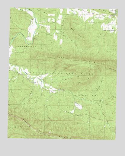
Leflore SE, OK USGS Topographic Map
Click on map above to begin viewing in our Map Viewer.

This topographic map contains these locations and features:
Feature Name Type Latitude Longitude GNIS ID View Map
Allen BranchStreamN34.7962°W94.8211°1101260View Map
Blue MountainSummitN34.8215°W94.7727°1101294View Map
Britton BranchStreamN34.8684°W94.7505°1101311View Map
Brushy MountainSummitN34.8493°W94.7941°1101317View Map
Cedar BranchStreamN34.7968°W94.8238°1101336View Map
Clearwater HollowValleyN34.7869°W94.7785°1101357View Map
Clebit RidgeRidgeN34.8059°W94.7875°1101358View Map
Coleman RidgeRidgeN34.8707°W94.8363°1101361View Map
Deadman GapGapN34.7723°W94.8722°1101392View Map
Dry RunStreamN34.8637°W94.8450°1101401View Map
High PointSummitN34.8454°W94.8455°1101459View Map
Holson Valley ChurchChurchN34.8082°W94.8516°1101471View Map
Indian Nations National Scenic and Wildlife AreaParkN34.7876°W94.7752°1100977View Map
Lillard CreekStreamN34.8190°W94.8630°1101505View Map
Negro BranchStreamN34.8001°W94.8333°1101557View Map
Redbank HollowValleyN34.8037°W94.8458°1101618View Map
ReichertPopulated PlaceN34.8693°W94.7541°1101621View Map
Reichert CemeteryCemeteryN34.8664°W94.7553°2711801View Map
Reichert Community Fire AssociationBuildingN34.8689°W94.7556°2657520View Map
Stark HollowValleyN34.8165°W94.8605°1101675View Map
Sulphur Spring HollowValleyN34.8068°W94.8358°1101681View Map
Upper Holson CreekStreamN34.7870°W94.7750°1101712View Map
Well HollowValleyN34.7868°W94.7658°1101728View Map
Wheeler HollowValleyN34.8008°W94.8267°1101731View Map
White BranchStreamN34.8709°W94.7527°1101732View Map
Wildhorse CreekStreamN34.7918°W94.7988°1101740View Map

Note: Coordinates in the location and feature list above are referenced to NAD83 datum.


Copyright (C) 2008-2024 Ryan Niemi / Sunset Dynamics ... All Rights Reserved