TopoQuest Logo
Do you find TopoQuest useful?
Help keep TopoQuest running and adding new maps/features by donating!
Bitcoin:  19c7KJd3qBynnjoSw5npx9KScwjBe4ifkT
Litecoin:  LXs6TkuXGGXo1vDsWCkWVdjQX94eUKd6ui
Home View Maps Find Maps Find Places Resources & Links


Lemon Gap, North Carolina Topographic Map

USGS Map Title: Lemon Gap, NC
USGS Map MRC: 35082G8
DRG (GeoTIFF) Download: o35082g8.tif


Neighboring USGS Topographic Map Quads:


  Neddy Mountain, TN  
35083H1
 

  Paint Rock, NC  
35082H8
 

  Hot Springs, NC  
35082H7
 

  Waterville, NC  
35083G1
 

  Lemon Gap, NC  
35082G8
 

  Spring Creek, NC  
35082G7
 

  Cove Creek Gap, NC  
35083F1
 

  Fines Creek, NC  
35082F8
 

  Sandymush, NC  
35082F7


Map MRC Location:

N36°
W83°
N36°
W82°
H8 H7 H6 H5 H4 H3 H2 H1
G8 G7 G6 G5 G4 G3 G2 G1
F8 F7 F6 F5 F4 F3 F2 F1
E8 E7 E6 E5 E4 E3 E2 E1
D8 D7 D6 D5 D4 D3 D2 D1
C8 C7 C6 C5 C4 C3 C2 C1
B8 B7 B6 B5 B4 B3 B2 B1
A8 A7 A6 A5 A4 A3 A2 A1
N35°
W83°
N35°
W82°

Lemon Gap, NC USGS 1:24K Topographic Map Preview:
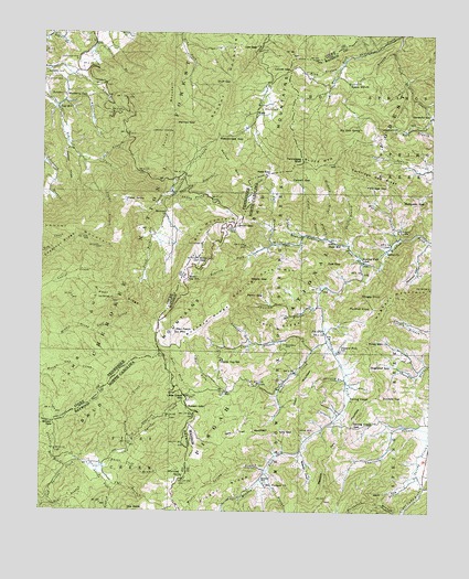
Lemon Gap, NC USGS Topographic Map
Click on map above to begin viewing in our Map Viewer.

This topographic map contains these locations and features:
Feature Name Type Latitude Longitude GNIS ID View Map
Balding ChapelChurchN35.7795°W82.8999°1008883View Map
Bear BranchStreamN35.7526°W82.9974°1008983View Map
Beasley CoveValleyN35.7658°W82.9159°1009061View Map
Bethel ChurchChurchN35.8187°W82.8890°1009222View Map
Big Rock SpringSpringN35.8504°W82.8979°1009376View Map
Blue MillPopulated PlaceN35.8562°W82.9951°1327668View Map
Bluff MountainSummitN35.8420°W82.9165°1327673View Map
Bluff MountainSummitN35.8412°W82.9065°1009504View Map
Bonnie Hill ChurchChurchN35.8618°W82.9021°1009537View Map
BoomerPopulated PlaceN35.8279°W82.9607°1327680View Map
Brown GapGapN35.7732°W82.9954°1009660View Map
Brushy MountainSummitN35.8509°W82.9468°1326912View Map
Brushy RidgeRidgeN35.7570°W82.9410°1009702View Map
Buckeye BranchStreamN35.7937°W82.9324°1009758View Map
Buckeye RidgeRidgeN35.8001°W82.9457°1009772View Map
Catpen BranchStreamN35.8220°W82.9113°1019564View Map
Catpen GapGapN35.8368°W82.9201°1010109View Map
Cherry CreekStreamN35.7662°W82.9710°1010210View Map
Chestnut RidgeRidgeN35.8211°W82.9887°1269450View Map
Crowder CemeteryCemeteryN35.8681°W82.9954°1328004View Map
Cud GapGapN35.8159°W82.9082°1010604View Map
Davis CemeteryCemeteryN35.7709°W82.9129°1010684View Map
Davis CoveValleyN35.7573°W82.8828°1010692View Map
Dixon MountainSummitN35.7818°W82.9171°1019985View Map
Dogwood GapGapN35.7890°W82.8938°1010869View Map
Double BranchStreamN35.8398°W82.9788°1328069View Map
Duckett TopSummitN35.7807°W82.8904°1020039View Map
East Fork Little CreekStreamN35.7809°W82.9399°1010991View Map
Ebbs MillPopulated PlaceN35.8212°W82.9071°1011011View Map
Fall BranchStreamN35.7615°W82.9793°1011150View Map
Fall BranchStreamN35.8198°W82.9257°1011152View Map
Fall BranchStreamN35.7604°W82.9274°1011159View Map
Fisher BranchStreamN35.8223°W82.9157°1011228View Map
Garenflo GapGapN35.8534°W82.8751°1020397View Map
Grigby CemeteryCemeteryN35.8643°W82.9988°1328341View Map
Gulf BranchStreamN35.8415°W82.9832°1328351View Map
Hickman CoveValleyN35.8150°W82.8789°1011996View Map
Hickory Ridge BranchStreamN35.8212°W82.9085°1012014View Map
Hogback MountainSummitN35.7990°W82.8924°1020794View Map
Hootowl HollowValleyN35.8447°W82.9917°1328480View Map
Hopis BranchStreamN35.8215°W82.8860°1012177View Map
Huff CemeteryCemeteryN35.8554°W82.9293°1328505View Map
Huff GapGapN35.8626°W82.9404°1328506View Map
Hurricane BranchStreamN35.8559°W82.9957°1328515View Map
Jack Trail MountainSummitN35.7701°W82.9382°1020915View Map
Joe Post OfficePost OfficeN35.7968°W82.9088°1024894View Map
Jones BranchStreamN35.8709°W82.8874°1012544View Map
Junebug SpringSpringN35.8518°W82.9768°1641035View Map
Kale GapGapN35.8387°W82.9268°1021011View Map
Keener SchoolSchoolN35.7579°W82.9276°1012603View Map
Laurel MountainSummitN35.8191°W82.9817°1326949View Map
Lemon GapGapN35.8254°W82.9376°1012822View Map
Lemon ProngStreamN35.8593°W82.9996°1328677View Map
Little CreekStreamN35.7948°W82.9074°1012942View Map
Little Creek GapGapN35.7804°W82.9535°1012949View Map
Little Fall BranchStreamN35.7618°W82.9804°1012959View Map
Locust GapGapN35.8654°W82.9210°1013060View Map
Long BranchStreamN35.7926°W82.9124°1013125View Map
Low GapGapN35.8715°W82.9365°1328792View Map
Low GapGapN35.7698°W82.9201°1013224View Map
Lynch (historical)Populated PlaceN35.8173°W82.8915°1017821View Map
Maple Spring BranchStreamN35.7609°W82.9265°1013317View Map
Marrow GapGapN35.8509°W82.9535°1328839View Map
Max Patch MountainSummitN35.7970°W82.9568°1013380View Map
Meadow Fork SchoolSchoolN35.7926°W82.9040°1013455View Map
Miller GapGapN35.8162°W82.9501°1013587View Map
Miller Gap SchoolSchoolN35.8101°W82.9524°1013589View Map
Mink BranchStreamN35.8670°W82.9051°1013621View Map
Moccasin GapGapN35.8318°W82.8763°1013647View Map
Muberry ChurchChurchN35.8587°W82.9929°1328976View Map
Muberry GapGapN35.8582°W82.9924°1328977View Map
New Prospect ChurchChurchN35.7570°W82.9271°1013932View Map
Panther BranchStreamN35.8045°W82.9104°1014205View Map
Panther KnobSummitN35.8032°W82.9004°1021795View Map
Partin GapGapN35.8070°W82.9340°1014239View Map
Partridge GapGapN35.8357°W82.8893°1014241View Map
Partridge Gap RidgeRidgeN35.8368°W82.8940°1014242View Map
Piney MountainSummitN35.7945°W82.8951°1021968View Map
Poor RidgeRidgeN35.8051°W82.9771°1639494View Map
Poplar Gap SchoolSchoolN35.7895°W82.9421°1014593View Map
Poplar SpringSpringN35.8312°W82.9732°1639495View Map
Pounding Mill BranchStreamN35.7618°W82.9901°1014623View Map
Rattlesnake BranchStreamN35.8326°W82.9588°1639548View Map
Rattlesnake Branch Recreation AreaParkN35.8384°W82.9535°1647138View Map
Rattlesnake GapGapN35.8476°W82.9443°1639549View Map
Raven Cliff BranchStreamN35.7632°W82.9768°1014761View Map
Reynolds CemeteryCemeteryN35.8234°W82.8854°1014828View Map
Rich MountainSummitN35.8198°W82.9490°1639586View Map
Roaring ForkStreamN35.8151°W82.8946°1014941View Map
Roaring Fork MountainSummitN35.8101°W82.9299°1022312View Map
Roaring Fork SchoolSchoolN35.8154°W82.8968°1014947View Map
Robert GapGapN35.7776°W82.9526°1014956View Map
Round MountainSummitN35.8495°W82.9590°1639674View Map
Round Mountain CampgroundLocaleN35.8384°W82.9557°1641036View Map
Round Mountain LookoutLocaleN35.8495°W82.9588°1641037View Map
Shavrey BranchStreamN35.7862°W82.9013°1015393View Map
Shelton BranchStreamN35.8323°W82.9571°1326984View Map
Skiffly BranchStreamN35.8195°W82.9018°1015563View Map
Smith CemeteryCemeteryN35.8629°W82.9985°1327046View Map
Snaggy PointSummitN35.8065°W82.8915°1022679View Map
Spring Creek GapGapN35.7723°W82.8999°1022744View Map
Sugar Camp BranchStreamN35.7570°W82.8768°1015899View Map
Tennessee BluffSummitN35.8418°W82.9163°1022906View Map
Township 8-Spring CreekCivilN35.7776°W82.8834°1026919View Map
Trail RidgeRidgeN35.7987°W82.9251°1016218View Map
Waddell CemeteryCemeteryN35.7940°W82.9215°1016381View Map
Walnut MountainSummitN35.8384°W82.9365°1327315View Map
Walnut Mountain Appalachian Trail ShelterLocaleN35.8368°W82.9363°1641038View Map
Walnut Mountain TrailTrailN35.8445°W82.9393°1647137View Map
WaspPopulated PlaceN35.8545°W82.9321°1327317View Map
Weedy GapGapN35.8109°W82.9274°1016494View Map
West Fork Little CreekStreamN35.7812°W82.9404°1016538View Map
West Fork Shut-In CreekStreamN35.8695°W82.9026°1016542View Map
Whiteoak SpringSpringN35.7590°W82.9540°1016627View Map

Note: Coordinates in the location and feature list above are referenced to NAD83 datum.


Copyright (C) 2008-2024 Ryan Niemi / Sunset Dynamics ... All Rights Reserved