TopoQuest Logo
Do you find TopoQuest useful?
Help keep TopoQuest running and adding new maps/features by donating!
Bitcoin:  19c7KJd3qBynnjoSw5npx9KScwjBe4ifkT
Litecoin:  LXs6TkuXGGXo1vDsWCkWVdjQX94eUKd6ui
Home View Maps Find Maps Find Places Resources & Links


Leon South, Oklahoma Topographic Map

USGS Map Title: Leon South, OK
USGS Map MRC: 33097G4
DRG (GeoTIFF) Download: o33097g4.tif


Neighboring USGS Topographic Map Quads:


  Spanish Fort, TX  
33097H5
 

  Leon North, OK  
33097H4
 

  Burneyville, OK  
33097H3
 

  Bonita, TX  
33097G5
 

  Leon South, OK  
33097G4
 

  Marysville, TX  
33097G3
 

  Saint Jo, TX  
33097F5
 

  Muenster West, TX  
33097F4
 

  Muenster East, TX  
33097F3


Map MRC Location:

N34°
W98°
N34°
W97°
H8 H7 H6 H5 H4 H3 H2 H1
G8 G7 G6 G5 G4 G3 G2 G1
F8 F7 F6 F5 F4 F3 F2 F1
E8 E7 E6 E5 E4 E3 E2 E1
D8 D7 D6 D5 D4 D3 D2 D1
C8 C7 C6 C5 C4 C3 C2 C1
B8 B7 B6 B5 B4 B3 B2 B1
A8 A7 A6 A5 A4 A3 A2 A1
N33°
W98°
N33°
W97°

Leon South, OK USGS 1:24K Topographic Map Preview:
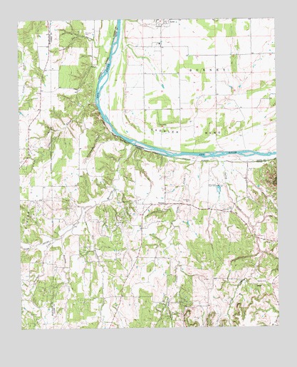
Leon South, OK USGS Topographic Map
Click on map above to begin viewing in our Map Viewer.

This topographic map contains these locations and features:
Feature Name Type Latitude Longitude GNIS ID View Map
Able CemeteryCemeteryN33.7987°W97.3989°1350854View Map
Bircham CreekStreamN33.7887°W97.4792°1372583View Map
Brushy Mound CemeteryCemeteryN33.7607°W97.4245°1353086View Map
BulcherPopulated PlaceN33.8004°W97.4297°1379474View Map
Camp CreekStreamN33.8193°W97.4136°1090843View Map
Camp CreekStreamN33.8195°W97.4134°1353627View Map
Cedar CreekStreamN33.8415°W97.4622°1091066View Map
Cedar CreekStreamN33.8418°W97.4622°1354063View Map
Cobb HollowValleyN33.7865°W97.4842°1354712View Map
Coker CemeteryCemeteryN33.7934°W97.4347°1354736View Map
East Mountain CreekStreamN33.7993°W97.4650°1356673View Map
Mountain CreekStreamN33.8240°W97.4442°1363378View Map
Owl HollowValleyN33.8643°W97.4549°1364642View Map
Roberts CemeteryCemeteryN33.7687°W97.3811°1366587View Map
Rock BluffCliffN33.8245°W97.4492°1366628View Map
Saddler BendBendN33.8287°W97.4167°1097569View Map
Scanland CemeteryCemeteryN33.8018°W97.4178°1367819View Map
Shiloh ChurchChurchN33.7957°W97.3989°1368175View Map
Valley CreekStreamN33.8187°W97.4061°1099204View Map
Williams CemeteryCemeteryN33.8676°W97.4675°1371567View Map

Note: Coordinates in the location and feature list above are referenced to NAD83 datum.


Copyright (C) 2008-2025 Ryan Niemi / Sunset Dynamics ... All Rights Reserved