TopoQuest Logo
Do you find TopoQuest useful?
Help keep TopoQuest running and adding new maps/features by donating!
Bitcoin:  19c7KJd3qBynnjoSw5npx9KScwjBe4ifkT
Litecoin:  LXs6TkuXGGXo1vDsWCkWVdjQX94eUKd6ui
Home View Maps Find Maps Find Places Resources & Links


Burneyville, Oklahoma Topographic Map

USGS Map Title: Burneyville, OK
USGS Map MRC: 33097H3
DRG (GeoTIFF) Download: o33097h3.tif


Neighboring USGS Topographic Map Quads:


  Healdton SW, OK  
34097A4
 

  Healdton SE, OK  
34097A3
 

  Overbrook, OK  
34097A2
 

  Leon North, OK  
33097H4
 

  Burneyville, OK  
33097H3
 

  Marietta West, OK  
33097H2
 

  Leon South, OK  
33097G4
 

  Marysville, TX  
33097G3
 

  Thackerville, OK  
33097G2


Map MRC Location:

N34°
W98°
N34°
W97°
H8 H7 H6 H5 H4 H3 H2 H1
G8 G7 G6 G5 G4 G3 G2 G1
F8 F7 F6 F5 F4 F3 F2 F1
E8 E7 E6 E5 E4 E3 E2 E1
D8 D7 D6 D5 D4 D3 D2 D1
C8 C7 C6 C5 C4 C3 C2 C1
B8 B7 B6 B5 B4 B3 B2 B1
A8 A7 A6 A5 A4 A3 A2 A1
N33°
W98°
N33°
W97°

Burneyville, OK USGS 1:24K Topographic Map Preview:
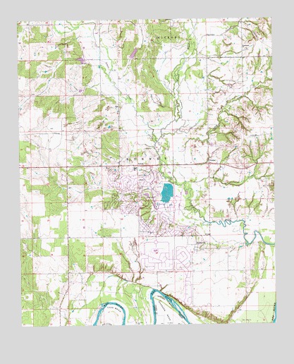
Burneyville, OK USGS Topographic Map
Click on map above to begin viewing in our Map Viewer.

This topographic map contains these locations and features:
Feature Name Type Latitude Longitude GNIS ID View Map
Bone CreekStreamN33.9332°W97.2939°1090392View Map
Box CemeteryCemeteryN33.9345°W97.3167°1090432View Map
BurneyvillePopulated PlaceN33.9079°W97.2889°1090721View Map
Burneyville CemeteryCemeteryN33.9056°W97.2864°2708455View Map
Burneyville Census Designated PlaceCensusN33.9055°W97.2913°2629937View Map
Cherokee CreekStreamN33.9812°W97.2934°1091238View Map
Dry CreekStreamN33.9351°W97.2992°1092228View Map
DunbarPopulated PlaceN33.9409°W97.2822°1092282View Map
EastmanPopulated PlaceN33.9884°W97.2647°1100377View Map
Eastman CemeteryCemeteryN33.9881°W97.2654°2708456View Map
Eastman Community Volunteer Fire DepartmentBuildingN33.9500°W97.2821°2658519View Map
Eastman HillsRangeN33.9904°W97.2517°1092462View Map
Falconhead AirportAirportN33.9276°W97.2984°2676458View Map
Falconhead Volunteer Fire DepartmentBuildingN33.9248°W97.3099°2658585View Map
Jimtown Volunteer Fire DepartmentBuildingN33.8819°W97.3568°2658481View Map
Lower Bayou Creek Site 17 DamDamN33.9918°W97.3453°1757711View Map
Lower Bayou Creek Site 17 ReservoirReservoirN33.9918°W97.3453°1757712View Map
Lower Bayou Creek Site 18 DamDamN33.9734°W97.3420°1757713View Map
Lower Bayou Creek Site 18 ReservoirReservoirN33.9731°W97.3410°1757714View Map
Oknoname 085006 DamDamN33.9334°W97.3003°1753445View Map
Oknoname 085006 ReservoirReservoirN33.9291°W97.3030°1753446View Map
Parker CemeteryCemeteryN33.9312°W97.2545°1096439View Map
PikePopulated PlaceN33.9645°W97.3253°1100738View Map
Simon CreekStreamN33.9498°W97.3070°1098058View Map
Township of BurneyCivilN33.9418°W97.3059°1824716View Map
TurnerPopulated PlaceN33.9401°W97.3167°1099067View Map
Turner Elementary SchoolSchoolN33.9395°W97.3178°1790577View Map
Turner High SchoolSchoolN33.9393°W97.3185°1790276View Map
Turner LodgeBuildingN33.9273°W97.3086°1099072View Map
Tyas BendBendN33.8801°W97.3309°1099128View Map

Note: Coordinates in the location and feature list above are referenced to NAD83 datum.


Copyright (C) 2008-2024 Ryan Niemi / Sunset Dynamics ... All Rights Reserved