TopoQuest Logo
Do you find TopoQuest useful?
Help keep TopoQuest running and adding new maps/features by donating!
Bitcoin:  19c7KJd3qBynnjoSw5npx9KScwjBe4ifkT
Litecoin:  LXs6TkuXGGXo1vDsWCkWVdjQX94eUKd6ui
Home View Maps Find Maps Find Places Resources & Links


Libertyville, Alabama Topographic Map

USGS Map Title: Libertyville, AL
USGS Map MRC: 31086B4
DRG (GeoTIFF) Download: o31086b4.tif


Neighboring USGS Topographic Map Quads:


  River Falls, AL  
31086C5
 

  Andalusia, AL  
31086C4
 

  Opp West, AL  
31086C3
 

  Carolina, AL  
31086B5
 

  Libertyville, AL  
31086B4
 

  Onycha, AL  
31086B3
 

  Wing, AL  
31086A5
 

  Watkins Bridge, AL  
31086A4
 

  Florala, AL  
31086A3


Map MRC Location:

N32°
W87°
N32°
W86°
H8 H7 H6 H5 H4 H3 H2 H1
G8 G7 G6 G5 G4 G3 G2 G1
F8 F7 F6 F5 F4 F3 F2 F1
E8 E7 E6 E5 E4 E3 E2 E1
D8 D7 D6 D5 D4 D3 D2 D1
C8 C7 C6 C5 C4 C3 C2 C1
B8 B7 B6 B5 B4 B3 B2 B1
A8 A7 A6 A5 A4 A3 A2 A1
N31°
W87°
N31°
W86°

Libertyville, AL USGS 1:24K Topographic Map Preview:
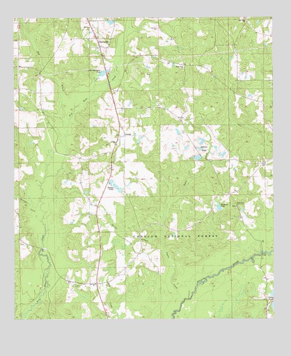
Libertyville, AL USGS Topographic Map
Click on map above to begin viewing in our Map Viewer.

This topographic map contains these locations and features:
Feature Name Type Latitude Longitude GNIS ID View Map
Bay BranchStreamN31.2082°W86.4744°159123View Map
Charles Woodham Lake DamDamN31.1702°W86.4000°161290View Map
Clear Creek Church (historical)ChurchN31.2127°W86.4755°161631View Map
Clifton Maddox DamDamN31.1785°W86.4483°161291View Map
Clifton Maddox DamDamN31.1802°W86.4500°161292View Map
Covington CountyCivilN31.2485°W86.4512°161545View Map
Cravey BridgeBridgeN31.1524°W86.3802°159459View Map
Cravey PondsLakeN31.1306°W86.3751°159460View Map
Elliotts QuartersLocaleN31.1313°W86.3777°161633View Map
Enon ChurchChurchN31.1713°W86.3925°159571View Map
Faithway ChurchChurchN31.2460°W86.4644°159591View Map
Five Runs CemeteryCemeteryN31.2457°W86.4322°159604View Map
Five Runs Church (historical)ChurchN31.2446°W86.4294°162921View Map
Gospel Center ChurchChurchN31.2182°W86.3911°161635View Map
Hillcrest PondReservoirN31.1952°W86.3783°161293View Map
Hillcrest PondReservoirN31.1988°W86.4096°161295View Map
Hillcrest Pond Number 1 DamDamN31.1952°W86.3783°161294View Map
Hillcrest Pond Number 2 DamDamN31.1985°W86.4083°161296View Map
Hillcrest PondsReservoirN31.1958°W86.4102°159777View Map
Judson Baptist ChurchChurchN31.1985°W86.4522°159876View Map
Judson CemeteryCemeteryN31.1979°W86.4505°1805646View Map
Juniper CreekStreamN31.1705°W86.4872°159879View Map
Kersey PondReservoirN31.2327°W86.3958°161636View Map
Lakeview (historical)Populated PlaceN31.1668°W86.4972°161637View Map
LibertyvillePopulated PlaceN31.2416°W86.4613°159941View Map
Libertyville Volunteer Fire DepartmentBuildingN31.2413°W86.4630°2331082View Map
Little Okeechobee PondReservoirN31.2271°W86.4571°159979View Map
Maddox PondsReservoirN31.1786°W86.4490°160026View Map
New Shady Grove ChurchChurchN31.2060°W86.4188°163422View Map
Oakey Ridge Baptist ChurchChurchN31.2482°W86.3886°160291View Map
Oakey Ridge CemeteryCemeteryN31.2488°W86.3872°1805363View Map
Poplar CreekStreamN31.1318°W86.4191°160429View Map
Red OakPopulated PlaceN31.1399°W86.4605°161640View Map
Red Oak ChurchChurchN31.1399°W86.4608°160478View Map
Red Oak Church (historical)ChurchN31.2335°W86.4577°161641View Map
Red Oak Volunteer Fire DepartmentBuildingN31.1408°W86.4607°2331026View Map
Shady Grove ChurchChurchN31.2299°W86.4197°160582View Map
Shiloh Church (historical)ChurchN31.2082°W86.4838°161643View Map
Spring BranchStreamN31.1591°W86.4300°160657View Map
StanleyPopulated PlaceN31.2010°W86.4477°160665View Map
Town of LibertyvilleCivilN31.2428°W86.4600°2406018View Map
Woodham PondReservoirN31.1715°W86.4013°160869View Map
Yellow River Lookout TowerTowerN31.1727°W86.3933°164449View Map

Note: Coordinates in the location and feature list above are referenced to NAD83 datum.


Copyright (C) 2008-2025 Ryan Niemi / Sunset Dynamics ... All Rights Reserved